Pritchett Creek Cascades
British Columbia • Pinecone Burke Park
By Armen Suny · Last verified Jun 2026
Difficulty
Moderate
Trail Length
6.6 km
Trail Type
Out And Back
About Pritchett Creek Cascades
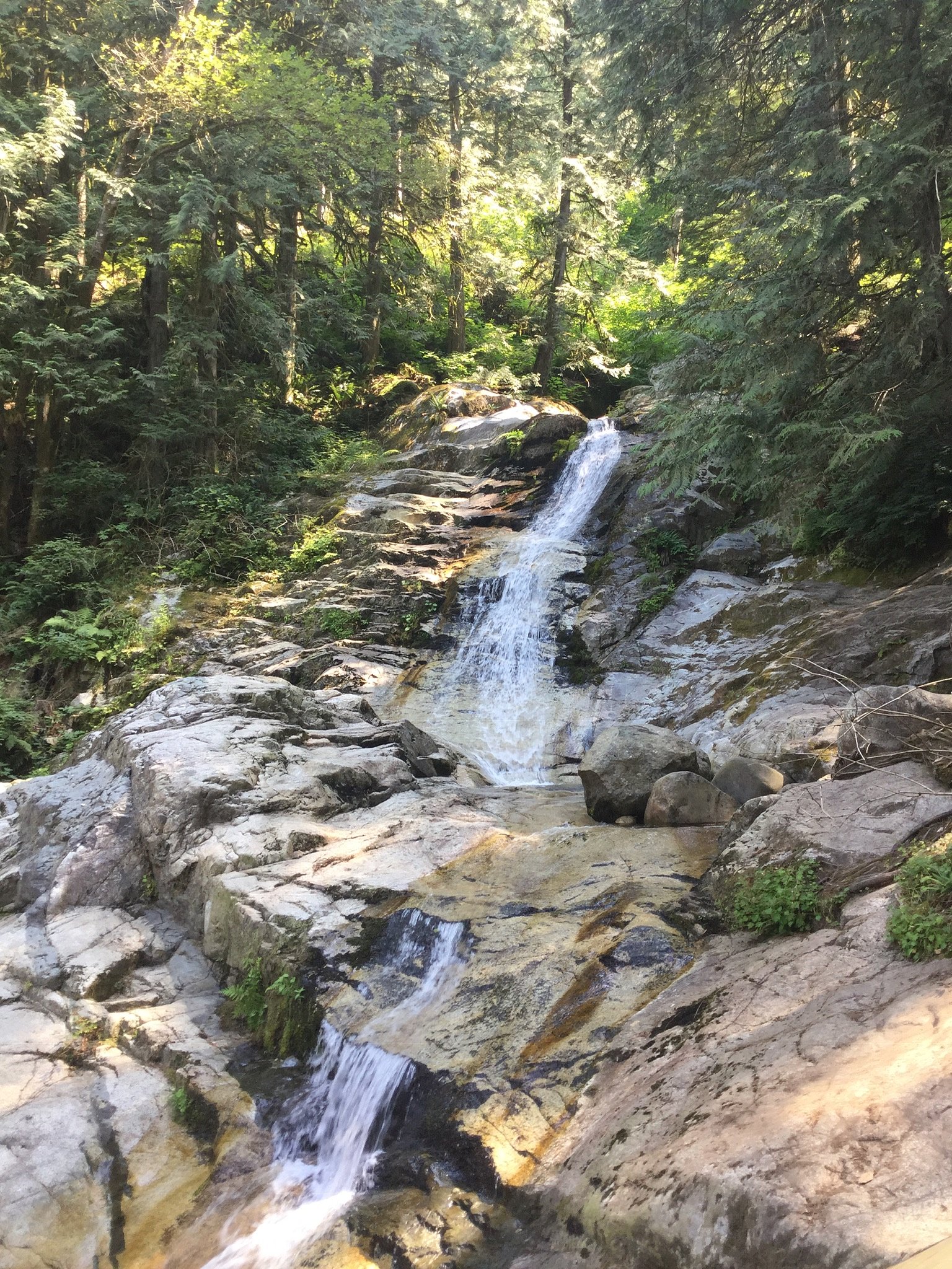
Pritchett Creek Cascades is a small series of cascades on Pritchett Creek in the Lower Mainland of British Columbia near the Canada–US border (coordinates ~49.325, -122.749). The feature appears to be a modest, multi-step cascade set in a wooded creek valley. Flow is typically highest in spring and after heavy rains and lower in late summer. Access appears informal and may require use of undeveloped forestry/utility roads and a short unmaintained trail or scramble to the creek; exact trailhead information and official signage appear limited.
The Setting
Pritchett Creek Cascades sits at 393 metres within Pinecone Burke Park, in the foothills of British Columbia.
Why This Waterfall Exists
Pritchett Creek Cascades flows over hard intrusive rock laid down about 145-162 million years ago. These resistant rocks form a durable ledge that water cannot easily wear away, creating the falls where softer material downstream has already eroded.
Trail & Hike Details
Trail Description
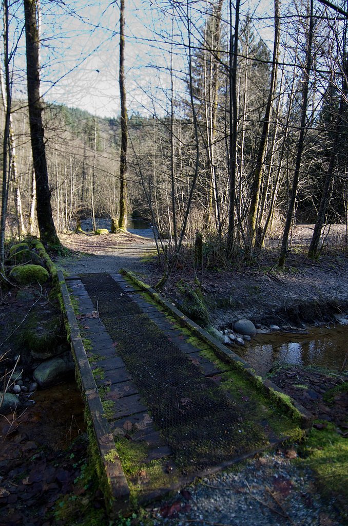
There does not appear to be an established, well-signed maintained trail to Pritchett Creek Cascades. Visitors report short, informal approaches from nearby roads or cleared corridors followed by a descent through brush and possibly a short scramble to the creek. Expect muddy, rooty, and uneven ground; streamside banks can be steep and slippery. Because routes are informal, route-finding skills and basic navigation (map/GPS) are recommended.
What to Expect
A small, natural cascade sequence rather than a single tall plunge. The creek is wooded and the cascades are likely spread over a short stretch; water volume varies seasonally (higher in spring/rainy periods). Vegetation typical of Lower Mainland riparian corridors (alder, salal, ferns) and mixed suburban/rural development in surrounding areas. No developed viewpoints, railings, or visitor facilities are expected. Footing will be wet and slippery near the water; scrambling on wet rocks may be required for close views.
Accessibility
The trail is not wheelchair accessible. Uneven terrain and elevation changes require steady footing.
Frequently Asked Questions
🐶 Are Dogs Allowed at Pritchett Creek Cascades?
❌ Dogs are not allowed
Are There Any Fees or Permits Required?
🆖 No fees required
🏊 Is There Swimming at Pritchett Creek Cascades?
❌ Swimming is not allowed
When to Visit
Late winter to late spring (after seasonal rains and snowmelt) generally provides the best flow. Summer offers easier access and drier approach conditions but lower streamflow. Avoid visiting during or immediately after heavy storms due to fast-rising water and slippery conditions.
Seasonal Access
The best time to visit is Spring, Summer, and Fall. Winter access may be limited. Check with Pinecone Burke Park for current conditions.
Safety Information
Primary hazards: slippery and unstable creek-side rocks, steep wet banks, sudden changes in water flow after rain, limited or no cell coverage in some stretches, and potential for private property/gates. Take a partner, tell someone your plan and expected return, carry a map and emergency supplies, and avoid risky climbs near the water. Exercise extra caution in winter (ice) and during high-water events.
Current Water Conditions
0.1 m³/s
Current discharge — how much water is flowing
Much lower than usual for this time of year
Based on 16 years of record
3.12 m
Water depth at gauge
7-Day Discharge Trend
What does this mean for your visit?
Flow is well below normal for this time of year, so the waterfall may be a trickle.
About This Gauge
7-Day Flow Outlook
Based on the WSC gauge OR CREEK NEAR COQUITLAM (4 km away).
Today
Barely Flowing
0.1 m³/s
4/10Tomorrow
Barely Flowing
0.1 m³/s
4/10Tue
Barely Flowing
0.1 m³/s
4/10Wed
Barely Flowing
0.1 m³/s
4/10Thu
Barely Flowing
0.1 m³/s
4/10Fri
Barely Flowing
0.1 m³/s
4/10Sat
Barely Flowing
0.1 m³/s
3/10Best window: Today — barely flowing flow, cloudy (trip score 4/10).
Best time of year: this gauge typically runs highest from mid April to late May, peaking in November.
How we calculate this
This is a transparent outlook, not a precise forecast. We take the waterfall's current flow strength (how it ranks against its historical normal for today, from the nearest WSC stream gauge), carry that ranking forward along the gauge's seasonal curve, and nudge it for forecast rain. Confidence is highest for the next day or two and falls further out. Always check official conditions and your own judgment before visiting — high flows can be dangerous.
Know when to go.
Get a free email alert when waterfalls near Vancouver hit peak flow. We only send when conditions are worth the trip — no weekly newsletters, no spam.
Weather Forecast
Location & Access
Getting There
Located near 49.325, -122.749 in the Lower Mainland, just north of the Canada–US border and within driving distance of Blaine, Birch Bay and the Metro Vancouver area. Expect to reach the general area by driving local highways (e.g., Highway 99/17/route depends on your start point) to a nearby access road or small parking/pullout. Final approach commonly uses unmarked or lightly used access roads, forestry/utility corridors, and short cross-country travel; consult local maps and recent visitor reports before going. Some access routes may cross private property, observe signage and stay on public right-of-ways.
Get Directions on Google MapsParking
No developed parking lot is known for this site. Expect limited roadside or informal pullout parking near the access road. Park legally and out of the flow of traffic; avoid blocking gates or private driveways. If you are unsure whether a parking area is private, err on the side of caution and seek public parking further away and walk in.
Elevation
393 metres above sea level
Coordinates
49.324953° N, -122.749007° W
Land Management
Managed by Government of British Columbia
Visitor Tips & Gear
• Expect no amenities (toilet, trash service); pack out what you bring. • Wear waterproof hiking boots with good traction; trekking poles help on slippery approaches. • Be prepared for mud, mosquitoes in warmer months, and dense brush. • Respect private property and posted signs; many access routes in the Lower Mainland cross or border private land. • Check recent trip reports or local trail resources before visiting for the latest access notes and hazards. • Do not attempt risky scrambles to get closer to cascades, wet rocks and steep banks are hazardous.
Where to Stay
Browse vacation cabins and private rentals nearby
Unique outdoor stays — tents, yurts, and treehouses
Rent a campervan or RV for your waterfall road trip
Some links are affiliate links. We may earn a commission at no extra cost to you.
Nearby Campground
Widgeon Creek Campsite
9.5 km away
Nearby Hot Springs
Hot springs near Vancouver, British Columbia
Dorr Fumarole Field
Dorr Fumarole Field reaches 194 degrees at 8,168 feet elevation on Mount Baker's active volcanic slopes, producing superheated ...

Sherman Crater Fumaroles
Sherman Crater Fumaroles register 266 degrees Fahrenheit at 9,463 feet elevation within the active volcanic crater atop Mount B...
Baker Hot Spring
Baker Hot Spring emerges at 108 degrees Fahrenheit on US Forest Service land in Mt. Baker National Forest, flowing 59.5 degrees...
Looking for a soak after your hike? Explore more hot springs near Vancouver, British Columbia on SoakingSprings.
Explore British Columbia springsAdditional Information
Nearby Attractions
Nearby points of interest in the general region include Boundary Bay / Boundary Bay Regional Park, Peace Arch Provincial Park and Peace Arch State Park (across the border), Crescent Beach / White Rock (to the west), and other Lower Mainland green spaces. Exact driving distances vary by chosen access route.
Wildlife
Typical Lower Mainland wildlife may be encountered: small mammals (raccoon, squirrel), birds (songbirds, raptors), and occasionally larger mammals such as deer. Black bears are uncommon near heavily settled border areas but may occur in less developed parts of the Fraser Valley; also be mindful of ticks in grassy/brushy areas. Use standard wildlife safety practices.
Cities near Pritchett Creek Cascades
Nearby Waterfalls
Writing about Pritchett Creek Cascades? Embed this waterfall on your site for free.