Mamquam Falls
British Columbia • 19 m
By Armen Suny · Last verified Jun 2026
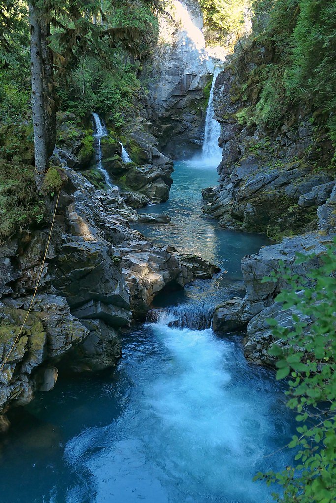
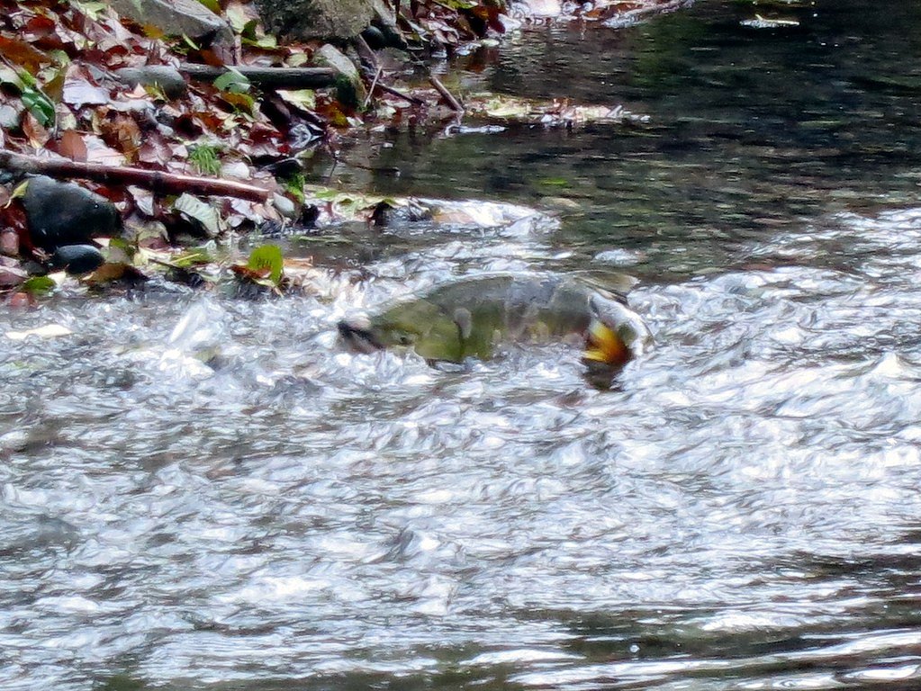
Photo Credits (5)
Difficulty
Moderate
Trail Length
3.2 km
Trail Type
Out And Back
Elevation Gain
183 m
About Mamquam Falls
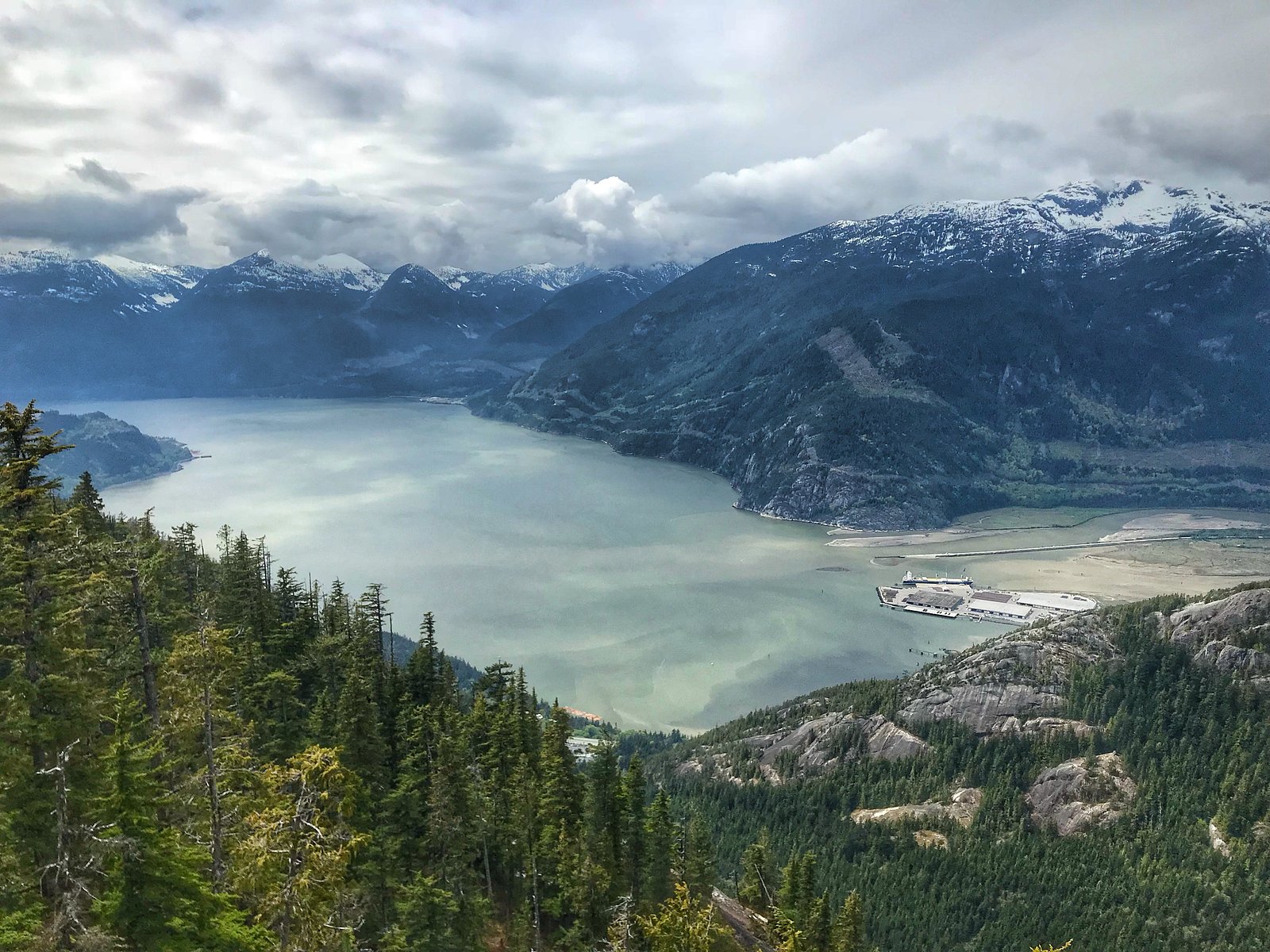
Mamquam Falls is a forested cascade on the Mamquam River in the Squamish area of southwestern British Columbia (approx. coordinates 49.7207, -123.0915). The falls sit in steep, wooded terrain and are most dramatic in spring snowmelt and after heavy rain. Access is from local roads off Highway 99 near Squamish; the setting is classic coastal temperate rainforest with mossy trees, steep banks, and viewpoints above the river. Exact measured height is not confirmed here.
The Setting
Mamquam Falls sits at 71 metres in the coastal lowlands of British Columbia. The falls drop 19 metres.
Why This Waterfall Exists
Mamquam Falls flows over hard intrusive rock laid down about 145-162 million years ago. These resistant rocks form a durable ledge that water cannot easily wear away, creating a 62-foot drop where softer material downstream has already eroded.
Trail & Hike Details
The Approach
The moderate 3.2-km out-and-back trail gains 183 metres of elevation on the way to the falls.
Trail Description
The approach is a wooded singletrack that climbs and descends moderate grades with some steeper, rooty or rocky sections. Trails may be narrow in places and can include short, steep switchbacks or stair-like sections. There are one or more viewpoints above the river/crest of the falls; there may not be a maintained route to the very base. Trail surfaces can be muddy and slippery when wet. Trails are typically unpaved and may be minimally maintained outside of summer season.
What to Expect
The falls drop 19 metres over hard intrusive rock.
Accessibility
The trail is not wheelchair accessible. Uneven terrain and elevation changes require steady footing.
Frequently Asked Questions
🐶 Are Dogs Allowed at Mamquam Falls?
❌ Dogs are not allowed
Are There Any Fees or Permits Required?
🆖 No fees required
🏊 Is There Swimming at Mamquam Falls?
❌ Swimming is not allowed
When to Visit
Spring for the fullest flows and dramatic runoff. Summer for easier, drier trail conditions and clearer access. Fall for color in the surrounding forest and generally lower visitor numbers. Winter can be icy and slippery and may require traction devices; travel with caution.
Seasonal Access
The best time to visit is Spring, Summer, and Fall. Winter access may be limited. Check with the managing park or local authority for current conditions.
Safety Information
Primary hazards include steep drop-offs, unstable or slippery banks near the falls, fast-flowing water, loose rock, and rapidly changing weather. Trails can be slippery when wet or icy, traction devices are recommended in winter. Cell coverage may be spotty. Leave no trace, and let someone know your plans if hiking alone. Check local advisories before visiting (trail closures, logging, high-water warnings).
Current Water Conditions
16.1 m³/s
Current discharge — how much water is flowing
Lower than usual for this time of year
Based on 33 years of record
1.58 m
Water depth at gauge
7-Day Discharge Trend
What does this mean for your visit?
Flow is lower than usual for this time of year.
About This Gauge
7-Day Flow Outlook
Based on the WSC gauge MAMQUAM RIVER ABOVE RING CREEK (1 km away).
Today
Low
16 m³/s
6/10Tomorrow
Low
16 m³/s
5/10Tue
Low
16 m³/s
5/10Wed
Low
17 m³/s
5/10Thu
Low
14 m³/s
5/10Fri
Moderate
17 m³/s
5/10Sat
Moderate
15 m³/s
5/10Best window: Today — low flow, sunny (trip score 6/10).
Best time of year: this gauge typically runs highest from late April to mid July, peaking in June.
How we calculate this
This is a transparent outlook, not a precise forecast. We take the waterfall's current flow strength (how it ranks against its historical normal for today, from the nearest WSC stream gauge), carry that ranking forward along the gauge's seasonal curve, and nudge it for forecast rain. Confidence is highest for the next day or two and falls further out. Always check official conditions and your own judgment before visiting — high flows can be dangerous.
Know when to go.
Get a free email alert when waterfalls near Vancouver hit peak flow. We only send when conditions are worth the trip — no weekly newsletters, no spam.
Weather Forecast
Location & Access
Getting There
From Vancouver (approx. 24.8 miles), drive north on Highway 99 toward Squamish. Follow local roads (typically Mamquam Road or rural access roads off the highway depending on the trailhead used) toward the Mamquam River area. The trailhead is reached via a short paved or gravel access road and may be signed; local maps or trail apps (AllTrails, local park/municipal pages) are recommended for the precise turn and current access.
Get Directions on Google MapsParking
Parking is generally limited and informal at a small roadside pullout or a small trailhead lot. Expect a few spaces only; vehicles may need to park off the shoulder. Do not block gates or driveways. Check signage and local information for any temporary closures or restrictions.
Elevation
71 metres above sea level
Coordinates
49.720651° N, -123.091463° W
Visitor Tips & Gear
Wear sturdy, grippy footwear and bring a rain shell (coastal weather can change quickly). Stay on the signed trail and behind any viewpoint barriers, banks and river edges may be unstable. If parking is limited, consider carpooling or visiting outside peak hours. Check recent trip reports or local trail apps (AllTrails, regional park pages) for up-to-date trail conditions, access changes, or logging activity. If you encounter wildlife, give it space and secure food.
As an Amazon Associate, we earn from qualifying purchases.
With 3.2 km and 183 m of elevation gain, sturdy boots and trekking poles will help on this moderate trail. Sun exposure on the trail makes good sun protection a must in summer.

Polarized Sunglasses (Knockaround)
Cuts glare off the water so you actually see the falls — and your photos turn out better too.

Columbia Watertight II Rain Jacket
Packs into its own pocket, seam-sealed, and keeps you dry from spray and surprise rain.

Earth Pak Waterproof Dry Bag
Keeps your phone and gear dry when waterfall mist soaks everything else.

Waterproof Phone Pouch (AiRunTech)
Cheap insurance — take photos right next to the falls without killing your phone.

Timberland Euro Sprint Mid Waterproof
Trusted waterproof boot with premium leather and grippy rubber sole — reliable on rocky, wet trails.

TrailBuddy Trekking Poles
Lightweight aluminum, cork grips, and flip-locks that actually hold — a best-seller for good reason.
Where to Stay
Browse vacation cabins and private rentals nearby
Unique outdoor stays — tents, yurts, and treehouses
Rent a campervan or RV for your waterfall road trip
Some links are affiliate links. We may earn a commission at no extra cost to you.
Nearby Campground
Mamquam River Campground
2.9 km away
Additional Information
Nearby Attractions
Squamish townsite (services), Shannon Falls Provincial Park, Stawamus Chief Provincial Park, Alice Lake Provincial Park, local mountain biking and climbing areas. Many other short hikes and viewpoints are within a short drive.
Wildlife
Black bears, coyotes, deer, small mammals, and a variety of birds inhabit the area. Practice bear-aware and wildlife-safe behaviour: store food securely, make noise on the trail, and never approach wildlife.
Cities near Mamquam Falls
Nearby Waterfalls

Writing about Mamquam Falls? Embed this waterfall on your site for free.