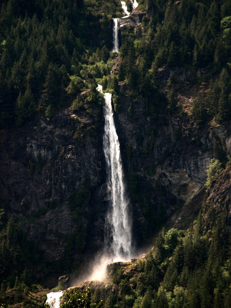
Madden Falls
British Columbia • 579 m
By Armen Suny · Last verified Jun 2026

Photo Credits (2)
About Madden Falls
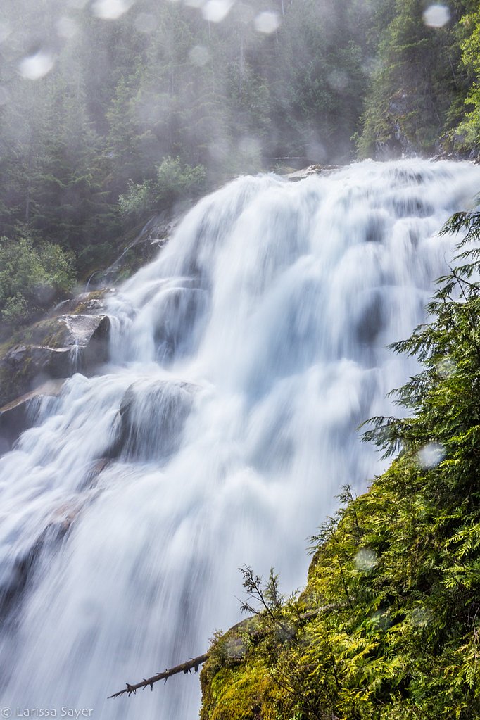
Madden Falls is a tiered horsetail waterfall located in the Pacific Ranges of British Columbia, Canada. With a total height of 579 m (1,900 ft), the falls are the 2nd tallest waterfall in Canada.
The Setting
Madden Falls sits at 566 metres within TANTALUS PARK, in the hills of British Columbia. At 579 metres, it is among the taller waterfalls in British Columbia.
Why This Waterfall Exists
Madden Falls flows over hard intrusive rock laid down about 145-162 million years ago. These resistant rocks form a durable ledge that water cannot easily wear away, creating a 1899-foot drop where softer material downstream has already eroded.
Nearby Falls Worth Visiting
Phantom Falls (100 m) lies 12.7 kilometres to the west. Also nearby: Crooked Falls (60 m, 1.1 km) and Ashlu Falls (10 m, 5.8 km).
Trail & Hike Details
Trail Description
There is limited authoritative trail documentation for Madden Falls. Expect a route that may be unmarked or lightly maintained, potentially involving forested terrain, uneven footing, roots, and muddy sections. Approach may require walking along or crossing creek channels, and route-finding skills could be necessary. Because official trail data is scarce, treat the hike as remote and prepare accordingly.
What to Expect
The falls plunge a dramatic 579 metres over hard intrusive rock.
Accessibility
Likely not accessible for wheelchairs or strollers. Expect uneven, potentially steep terrain and unmaintained trails or boot paths.
Frequently Asked Questions
🐶 Are Dogs Allowed at Madden Falls?
❌ Dogs are not allowed
Are There Any Fees or Permits Required?
🆖 No fees required
🏊 Is There Swimming at Madden Falls?
❌ Swimming is not allowed
When to Visit
Late spring to early summer for highest flows and scenic water volume. Summer provides easier access on dry roads but lower flows. Avoid winter unless experienced with winter backcountry travel, as snow, ice, and avalanche risk may make access hazardous.
Seasonal Access
The best time to visit is Spring, Summer, and Fall. Winter access may be limited. Check with the managing park or local authority for current conditions.
Safety Information
Potential hazards include slippery and unstable rocks near the falls, steep banks and drop-offs, fast cold water, fallen trees/loose debris, limited or no cell service, and possible private land or gated roads. Seasonal hazards include high water during spring runoff and icy conditions in winter. Carry appropriate safety gear, tell someone your route and expected return time, and avoid approaching the brink or climbing on wet rock. Confirm road access and obey any closure signs.
Current Water Conditions
338.0 m³/s
Current discharge — how much water is flowing
Lower than usual for this time of year
Based on 71 years of record
3.51 m
Water depth at gauge
7-Day Discharge Trend
What does this mean for your visit?
Flow is lower than usual for this time of year.
About This Gauge
This gauge is on a nearby waterway and may not reflect exact conditions at the falls.
7-Day Flow Outlook
Based on the WSC gauge SQUAMISH RIVER NEAR BRACKENDALE (13 km away).
Today
Low
338 m³/s
6/10Tomorrow
Low
351 m³/s
5/10Tue
Low
343 m³/s
5/10Wed
Low
344 m³/s
5/10Thu
Low
330 m³/s
5/10Fri
Low
357 m³/s
4/10Sat
Low
378 m³/s
4/10Best window: Today — low flow, sunny (trip score 6/10).
Best time of year: this gauge typically runs highest from late May to late August, peaking in June.
How we calculate this
This is a transparent outlook, not a precise forecast. We take the waterfall's current flow strength (how it ranks against its historical normal for today, from the nearest WSC stream gauge), carry that ranking forward along the gauge's seasonal curve, and nudge it for forecast rain. Confidence is highest for the next day or two and falls further out. Always check official conditions and your own judgment before visiting — high flows can be dangerous.
Know when to go.
Get a free email alert when waterfalls near Vancouver hit peak flow. We only send when conditions are worth the trip — no weekly newsletters, no spam.
Weather Forecast
Location & Access
Getting There
From the Vancouver area, travel north via Highway 99 (Sea-to-Sky Highway) toward Squamish/Whistler. The waterfall coordinates are inland from the highway; reaching the immediate vicinity likely requires driving on secondary or forest roads and then hiking. Access may be via unpaved logging or park service roads and an unmarked or minimally signed trail. Verify current road and trail conditions, and check with local land management agencies (e.g., BC Parks, local municipality) before attempting.
Get Directions on Google MapsParking
Parking is likely limited to a small pullout or informal parking near a forest/maintenance road or trailhead. Do not block gates or private driveways. Exact official parking availability is not well-documented, plan for limited parking and the possibility of needing to park further away and hike in.
Elevation
566 metres above sea level
Coordinates
49.889708° N, -123.315179° W
Land Management
Managed by Government of British Columbia
Visitor Tips & Gear
1) Confirm land status and access (public vs. private) before visiting; respect posted signs. 2) Check recent trail reports or local sources for road and trail conditions. 3) Wear sturdy hiking boots with good traction for wet and uneven terrain. 4) Bring navigation (map/GPS), trails may be unmarked. 5) Avoid getting on slick rocks near the edge; currents and undercut banks can be dangerous. 6) Leave no trace, pack out all waste. 7) If traveling on forest roads, high-clearance or 4WD may be advisable and check for seasonal road closures.
Where to Stay
Browse vacation cabins and private rentals nearby
Unique outdoor stays — tents, yurts, and treehouses
Rent a campervan or RV for your waterfall road trip
Some links are affiliate links. We may earn a commission at no extra cost to you.
Nearby Campground
Squamish Riverside Campground
3.3 km away
Additional Information
Nearby Attractions
Squamish and the Sea-to-Sky corridor attractions: Shannon Falls, Stawamus Chief, Squamish River valley, and parts of Garibaldi Provincial Park. Exact proximity to popular parks may vary; verify route planning.
Wildlife
Typical coastal mountain wildlife may be present: black bears, cougars (rare but possible), deer, small mammals, and a variety of birds. Practice bear-aware habits (make noise, store food properly).
Cities near Madden Falls
Nearby Waterfalls
Writing about Madden Falls? Embed this waterfall on your site for free.