
Ashlu Falls
British Columbia • 10 m
By Armen Suny · Last verified Jun 2026
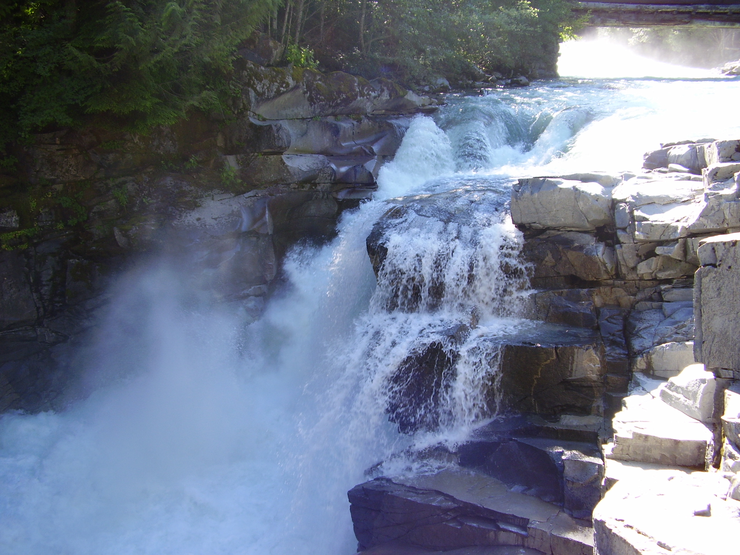
Photo Credits (1)
Difficulty
Drive Up
Trail Length
0.5 km
Trail Type
Out And Back
Elevation Gain
15 m
About Ashlu Falls
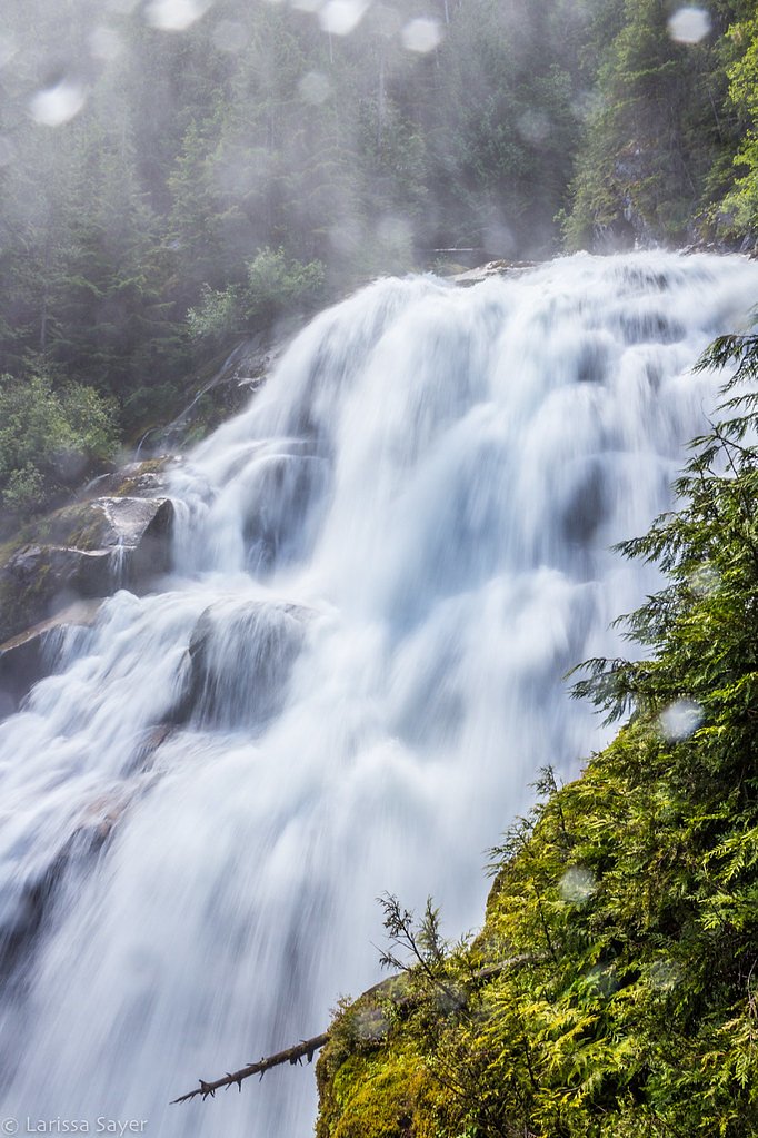
Ashlu Falls is a short but significant waterfall along lower Ashlu Creek. The falls are located about 6 km above the mouth of Ashlu Creek and mark the head of Ashlu Canyon. The creek is actually crossed by a logging road bridge between the two tiers.
The Setting
Ashlu Falls sits at 248 metres in the foothills of British Columbia. The falls drop 10 metres.
Why This Waterfall Exists
Ashlu Falls flows over hard intrusive rock laid down about 145-162 million years ago. These resistant rocks form a durable ledge that water cannot easily wear away, creating a 33-foot drop where softer material downstream has already eroded.
Nearby Falls Worth Visiting
Madden Falls (579 m) lies 5.8 kilometres to the southeast. Also nearby: Phantom Falls (100 m, 12.9 km) and Crooked Falls (60 m, 4.8 km).
Trail & Hike Details
The Approach
No hiking required. Ashlu Falls is accessible by vehicle with a roadside viewing area.
Trail Description
A short, mainly flat out-and-back walk from the roadside parking/pullout to a viewpoint above the gorge. The main viewpoint is reached on a brief forested path that may include roots, rocks and a small scramble on an unmaintained section. There is limited or no formal viewing infrastructure (guardrails or boardwalks), and getting down to the riverbank or base of the falls requires route finding and scrambling over steep, slippery rock.
What to Expect
The falls drop 10 metres over hard intrusive rock.
Accessibility
This waterfall is viewable from a vehicle-accessible area. No hiking is required.
Frequently Asked Questions
🐶 Are Dogs Allowed at Ashlu Falls?
❌ Dogs are not allowed
Are There Any Fees or Permits Required?
🆖 No fees required
🏊 Is There Swimming at Ashlu Falls?
❌ Swimming is not allowed
When to Visit
Late spring to early summer for highest flows and dramatic water volume. Summer and fall are fine for easier road conditions and clearer weather. Winter visits are possible but may present icy trails, frozen spray, and limited road access, take extra precautions.
Seasonal Access
The best time to visit is Spring, Summer, and Fall. Winter access may be limited. Check with the managing park or local authority for current conditions.
Safety Information
Hazards include fast, cold water, strong currents, slippery rocks and steep drop-offs. Road and trail conditions can change quickly due to weather or forestry activity. Cell service may be unreliable. Do not attempt to climb down to the base of the falls without proper experience, rescues are difficult in this terrain. Wear appropriate footwear and supervise children closely.
Current Water Conditions
11.5 m³/s
Current discharge — how much water is flowing
Lower than usual for this time of year
Based on 33 years of record
2.98 m
Water depth at gauge
7-Day Discharge Trend
What does this mean for your visit?
Flow is lower than usual for this time of year.
About This Gauge
This gauge is on a nearby waterway and may not reflect exact conditions at the falls.
7-Day Flow Outlook
Based on the WSC gauge CLOWHOM RIVER NEAR CLOWHOM LAKE (17 km away).
Today
Low
11 m³/s
6/10Tomorrow
Low
12 m³/s
6/10Tue
Low
11 m³/s
5/10Wed
Low
11 m³/s
5/10Thu
Low
13 m³/s
4/10Fri
Moderate
13 m³/s
5/10Sat
Moderate
12 m³/s
5/10Best window: Today — low flow, sunny (trip score 6/10).
Best time of year: this gauge typically runs highest from early May to late July, peaking in June.
How we calculate this
This is a transparent outlook, not a precise forecast. We take the waterfall's current flow strength (how it ranks against its historical normal for today, from the nearest WSC stream gauge), carry that ranking forward along the gauge's seasonal curve, and nudge it for forecast rain. Confidence is highest for the next day or two and falls further out. Always check official conditions and your own judgment before visiting — high flows can be dangerous.
Know when to go.
Get a free email alert when waterfalls near Vancouver hit peak flow. We only send when conditions are worth the trip — no weekly newsletters, no spam.
Weather Forecast
Location & Access
Getting There
From Vancouver (approximately 43 miles / ~70 km north), drive north on Highway 99 through Squamish toward Pemberton. Look for the turnoff to the Ashlu Forest Service Road / Ashlu area; the falls are accessed via a short side road or pullout a few kilometres up the FSR or from a roadside turnout near the bridge over the creek. Coordinates: 49.934, -123.3595. Expect a mix of paved and gravel roads and limited signage; follow local maps and check current FSR conditions.
Get Directions on Google MapsParking
Small roadside pullout(s) near the Ashlu Falls viewpoint/bridge. Parking is informal and limited; vehicles may be parked on gravel shoulder. Pullouts can be muddy or rutted in wet seasons. Be cautious of logging or industrial traffic on forest service roads.
Elevation
248 metres above sea level
Coordinates
49.934031° N, -123.359481° W
Visitor Tips & Gear
• Wear sturdy, grippy shoes; rocks and trail sections can be slippery. • Keep a safe distance from the cliff edge and fast-moving water, there are steep drop-offs and strong currents. • Park fully off the road where allowed; watch for logging trucks. • No facilities, bring water, snacks, and pack out all trash. • Check local FSR and weather reports before travel; some gravel roads may require high-clearance or 4x4 in wet conditions. • Respect private/industrial signs and do not enter closed roads.
As an Amazon Associate, we earn from qualifying purchases.
For this easy 0.5 km trail, lightweight trail shoes and a water bottle are usually sufficient. Sun exposure on the trail makes good sun protection a must in summer.

Polarized Sunglasses (Knockaround)
Cuts glare off the water so you actually see the falls — and your photos turn out better too.

Columbia Watertight II Rain Jacket
Packs into its own pocket, seam-sealed, and keeps you dry from spray and surprise rain.

Earth Pak Waterproof Dry Bag
Keeps your phone and gear dry when waterfall mist soaks everything else.

Waterproof Phone Pouch (AiRunTech)
Cheap insurance — take photos right next to the falls without killing your phone.

JOBY GorillaPod Starter Kit
Wraps around railings and rocks for long-exposure waterfall shots — no flat surface needed.

OR Sombriolet Sun Hat
UPF 50+ sun protection with vents so your head doesn't cook on exposed trail sections.
Where to Stay
Browse vacation cabins and private rentals nearby
Unique outdoor stays — tents, yurts, and treehouses
Rent a campervan or RV for your waterfall road trip
Some links are affiliate links. We may earn a commission at no extra cost to you.
Nearby Campground
High Falls (5.5km) Recreation Site
3.8 km away
Additional Information
Nearby Attractions
Squamish (town amenities), Stawamus Chief Provincial Park, Shannon Falls Provincial Park, Alice Lake Provincial Park, other Ashlu River/Canyon recreational areas (noting some are used for technical kayaking/rafting).
Wildlife
Black bears, black-tailed deer, small mammals, and various birds (including raptors). Standard bear and wildlife precautions recommended, store food securely and maintain distance from animals.
Cities near Ashlu Falls
Nearby Waterfalls
Writing about Ashlu Falls? Embed this waterfall on your site for free.