Difficulty
Moderate
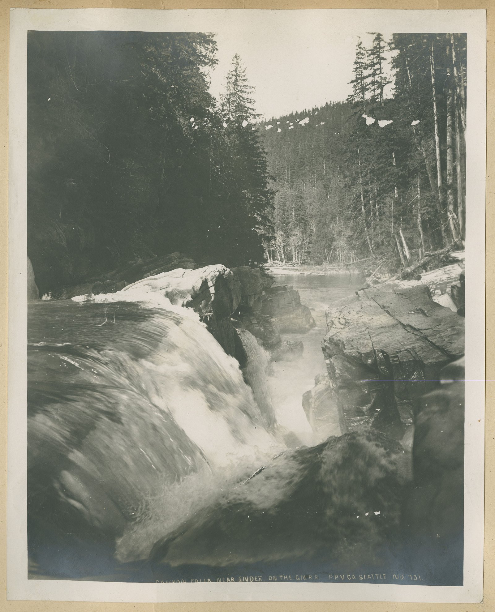
About Kennebas Falls
Kennebas Falls is a remote waterfall in northwestern Ontario (coords 48.3258, -91.1344) set in a boreal/forest landscape. The falls are reached via forest roads and informal trails; visitor reports suggest a relatively undeveloped site with natural, rugged character. Water flow and appearance are highly seasonal, peak flow is typically in spring and after heavy rains, while late summer can be lower. Winter can produce ice formations but requires winter travel skills.
The Setting
Kennebas Falls sits at 402 metres within Quetico Provincial Park, in the foothills of Ontario.
Why This Waterfall Exists
Kennebas Falls flows over hard intrusive rock, primarily granodiorite and granite, laid down over 2.5-3.2 billion years ago. These resistant rocks form a durable ledge that water cannot easily wear away, creating the falls where softer material downstream has already eroded.
Nearby Falls Worth Visiting
Little Falls (12 m) lies 2.4 kilometres to the southeast. Also nearby: Canyon Falls (9 m, 1.3 km).
Trail & Hike Details
Trail Description
Trail access appears to be primitive and may consist of an unmaintained footpath from a roadside pullout. Expect uneven footing, roots, rocks, muddy sections, and potential bushwhacking in places. There are likely no boardwalks, railings, or interpretive signs. Route-finding skills and a map/GPS are recommended. Follow established boot-worn routes and avoid creating new trails to protect vegetation.
What to Expect
A natural, undeveloped waterfall in a boreal forest setting. Surrounding terrain may include mixed hardwood and conifer stands, exposed bedrock, and wet, mossy banks. Water conditions vary with season, higher and more dramatic in spring, reduced flow in late summer. Facilities are minimal to non-existent; plan to be self-sufficient. Wildlife in the region can include moose, black bear, deer, wolves, beavers, and various waterfowl.
Accessibility
The trail is not wheelchair accessible. Uneven terrain and elevation changes require steady footing.
Frequently Asked Questions
🐶 Are Dogs Allowed at Kennebas Falls?
❌ Dogs are not allowed
Are There Any Fees or Permits Required?
🆖 No fees required
🏊 Is There Swimming at Kennebas Falls?
❌ Swimming is not allowed
When to Visit
Spring (late snowmelt/early runoff) for the highest flows and dramatic waterfalls. Fall for colour and cooler temperatures. Summer for easier travel conditions and longer days, though flows may be lower. Winter can offer frozen scenery but requires snowmobile, skis or snowshoe experience and avalanche/ice-safety awareness where applicable.
Seasonal Access
The best time to visit is Spring, Summer, Fall, and Winter. Check with Quetico Provincial Park for current conditions.
Safety Information
Significant hazards include slippery wet rock near the falls, fast currents, cold water, steep or unstable banks, remote location with limited cell reception, and changing weather. Bring appropriate clothing, navigation tools, first aid, and travel with a partner when possible. Exercise caution with photography near edges and do not climb on wet rock. If bear country, carry deterrents and know how to use them. Roads to the trailhead may be rough, check conditions and road closures before travel.
Know when to go.
Get a free email alert when waterfalls near Atikokan hit peak flow. We only send when conditions are worth the trip — no weekly newsletters, no spam.
Weather Forecast
Location & Access
Getting There
The falls are in a remote area of northwestern Ontario. Nearest communities include Atikokan (~41 miles), Winton (~48 miles) and Lutsen, MN (~51 miles). Access is typically by paved highways followed by gravel or logging roads; the final approach may be on an unmaintained spur and/or footpath. A high-clearance vehicle or 4x4 may be advisable for gravel/logging roads. Plan for limited or no cell coverage.
Get Directions on Google MapsParking
No formal parking lot is known; expect an informal pullout or roadside parking on a gravel/logging road. Park clear of the road, use hazard lights, and avoid blocking gates or private drives. Parking conditions may be muddy or uneven.
Elevation
402 metres above sea level
Coordinates
48.325806° N, -91.134427° W
Land Management
Managed by Ontario Parks
Visitor Tips & Gear
1) Tell someone your route and expected return time; cell service may be unreliable. 2) Wear sturdy, waterproof hiking boots and expect slippery rocks. 3) Carry a map, compass or GPS, insect repellent (ticks and mosquitoes), and bear safety items where recommended (bear spray, noise). 4) Avoid getting too close to the lip or edges; wet rock is slippery and currents can be strong. 5) Respect private land and posted signs; do not trespass on gated or signed private roads. 6) Leave no trace, pack out all trash.
Where to Stay
Browse vacation cabins and private rentals nearby
Unique outdoor stays — tents, yurts, and treehouses
Rent a campervan or RV for your waterfall road trip
Some links are affiliate links. We may earn a commission at no extra cost to you.
Additional Information
Nearby Attractions
Atikokan (gateway to canoe country and provincial forests), Quetico Provincial Park (backcountry canoeing and fishing), Lake Superior shoreline and provincial parks to the east and south. Lutsen (Minnesota) and the North Shore of Lake Superior are regional attractions but are across the international border.
Wildlife
Typical boreal species: moose, black bear, white-tailed deer, wolves, beaver, river otter, small mammals and various bird species. Take standard wildlife precautions: store food properly, make noise on trails, and be alert during dawn/dusk hours.
Cities near Kennebas Falls
Nearby Waterfalls
Writing about Kennebas Falls? Embed this waterfall on your site for free.