Gold Creek Upper Falls
British Columbia • Golden Ears Park
By Armen Suny · Last verified Jun 2026
Difficulty
Moderate
Trail Length
10.3 km
Trail Type
Out And Back
Elevation Gain
389 m
About Gold Creek Upper Falls
Gold Creek Upper Falls is a small cascade on Gold Creek in the Fraser Valley region of British Columbia, near the communities of Lynden, Abbotsford and Sumas. The falls sit in a forested creek valley and are most notable for seasonal flow changes (higher in spring snowmelt and after heavy rain). Exact details about official trail infrastructure and measured vertical drop are limited; visitors typically reach viewpoints by short, informal trails or roadside approaches.
The Setting
Gold Creek Upper Falls sits at 288 metres within Golden Ears Park, in the foothills of British Columbia.
Why This Waterfall Exists
Gold Creek Upper Falls flows over hard intrusive rock laid down about 145-162 million years ago. These resistant rocks form a durable ledge that water cannot easily wear away, creating the falls where softer material downstream has already eroded.
Nearby Falls Worth Visiting
Upper Kanaka Falls (25 m) lies 11.9 kilometres to the south.
Trail & Hike Details
The Approach
The moderate 10.3-km out-and-back trail gains 389 metres of elevation on the way to the falls.
Trail Description
Access appears to be via short, unmaintained paths or logging/forestry roads descending to the creek. Trails may be faint and involve some scrambling over roots and rocks. There may not be established viewing platforms or signage. Expect uneven footing and variable route-finding; bring navigation or follow GPS coordinates. Because official trail descriptions are limited, treat the route as informal and subject to seasonal changes (mud, washouts).
What to Expect
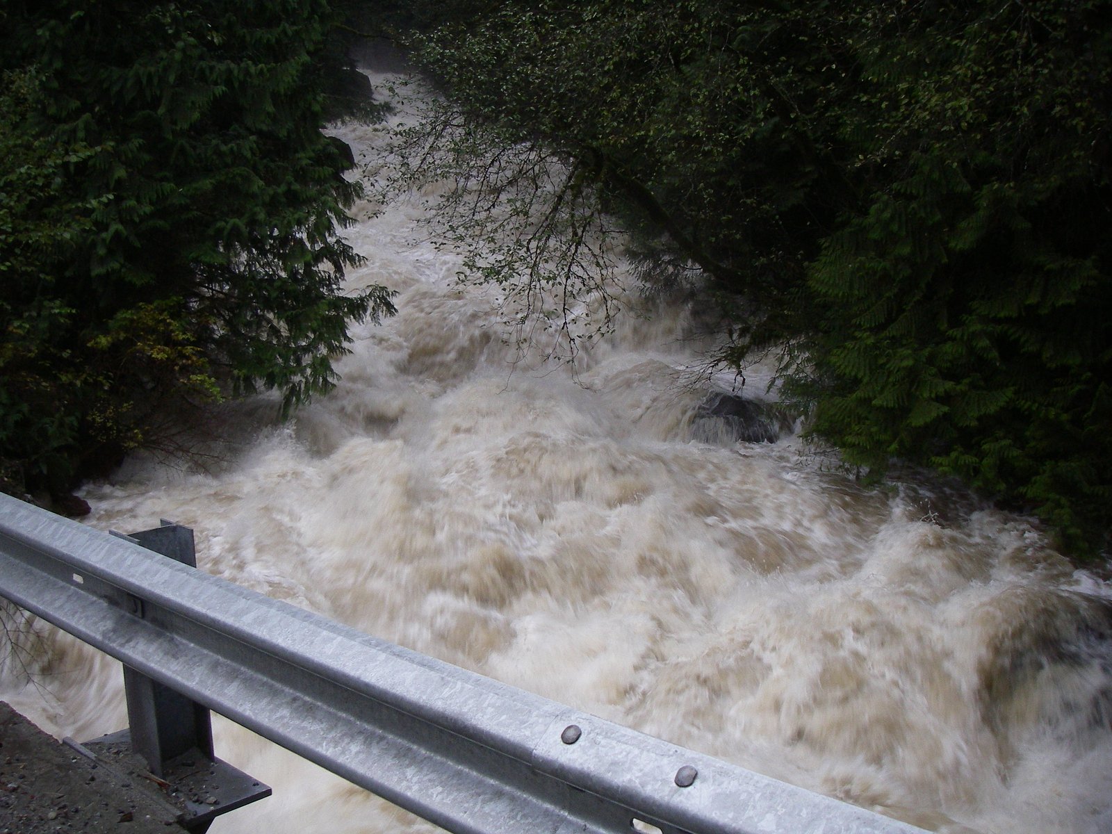
A small, forested creek setting with a cascade rather than a single large plunge. Flow is strongly seasonal, highest in spring and after storms and lower in late summer and extended dry periods. The area is wooded with typical Fraser Valley second-growth forest; expect mud, roots, and slick rock near the water. Cell coverage may be intermittent. Wildlife in the area can include deer, small mammals, birds, insects and the possibility of larger mammals (see safetyInformation).
Accessibility
The trail involves steep, uneven terrain with significant elevation change and is not accessible to mobility devices.
Frequently Asked Questions
🐶 Are Dogs Allowed at Gold Creek Upper Falls?
❌ Dogs are not allowed
Are There Any Fees or Permits Required?
🆖 No fees required
🏊 Is There Swimming at Gold Creek Upper Falls?
❌ Swimming is not allowed
When to Visit
Late spring (snowmelt and higher runoff) for the most impressive flows. Early summer can be pleasant for milder weather and vegetation; fall can provide lower crowds and autumn colors but reduced flow. Winter access may be slippery or hazardous due to ice and mud; only attempt with appropriate gear and local knowledge.
Seasonal Access
The best time to visit is Spring, Summer, and Fall. Winter access may be limited. Check with Golden Ears Park for current conditions.
Safety Information
Hazards: slippery rocks and wet roots near the creek; fast or cold water during and after storms; possible steep or unstable banks; limited or no marked trail and potential for getting off-route; seasonal mud and washouts; limited cell reception in some spots; possible presence of timber operations or private land with restricted access. Carry appropriate footwear, avoid creek crossings when flow is high, tell someone your route and expected return time, and check local advisories before visiting.
Current Water Conditions
0.2 m³/s
Current discharge — how much water is flowing
Much lower than usual for this time of year
Based on 67 years of record
0.13 m
Water depth at gauge
7-Day Discharge Trend
What does this mean for your visit?
Flow is well below normal for this time of year, so the waterfall may be a trickle.
About This Gauge
This gauge is on a nearby waterway and may not reflect exact conditions at the falls.
7-Day Flow Outlook
Based on the WSC gauge NORTH ALOUETTE RIVER AT 232ND STREET, MAPLE RIDGE (16 km away).
Today
Barely Flowing
0.2 m³/s
4/10Tomorrow
Barely Flowing
0.2 m³/s
4/10Tue
Barely Flowing
0.2 m³/s
4/10Wed
Barely Flowing
0.2 m³/s
4/10Thu
Barely Flowing
0.2 m³/s
3/10Fri
Barely Flowing
0.2 m³/s
4/10Sat
Barely Flowing
0.2 m³/s
3/10Best window: Today — barely flowing flow, fog (trip score 4/10).
Best time of year: this gauge typically runs highest from early November to mid November, peaking in November.
How we calculate this
This is a transparent outlook, not a precise forecast. We take the waterfall's current flow strength (how it ranks against its historical normal for today, from the nearest WSC stream gauge), carry that ranking forward along the gauge's seasonal curve, and nudge it for forecast rain. Confidence is highest for the next day or two and falls further out. Always check official conditions and your own judgment before visiting — high flows can be dangerous.
Know when to go.
Get a free email alert when waterfalls near Abbotsford hit peak flow. We only send when conditions are worth the trip — no weekly newsletters, no spam.
Weather Forecast
Location & Access
Getting There
Coordinates: 49.3564, -122.4519. The falls lie in the general Sumas/Abbotsford area in the Fraser Valley. Approach is typically by local roads in the Gold Creek area; final access may be via unmarked pullouts, informal forestry tracks or short footpaths. Verify route locally before traveling and consult current maps or local landowner/park signage, parts of the valley may be on Crown land or adjacent to private property.
Get Directions on Google MapsParking
Likely limited; expect roadside parking or small informal pullouts rather than a formal lot. Park well clear of the travel lane and follow any posted signage. If unsure, plan to park in a nearby established trailhead or community parking area and walk in.
Elevation
288 metres above sea level
Coordinates
49.356398° N, -122.451916° W
Land Management
Managed by Government of British Columbia
Visitor Tips & Gear
1) Check recent trip reports or local park/forest service notices for access changes or closures; trail conditions can change quickly after rain or logging activity. 2) Wear sturdy waterproof footwear with good traction; approach banks and wet rocks cautiously. 3) Avoid entering the water during high flows, currents can be stronger than they appear. 4) Respect private property boundaries and posted signs; if access crosses or borders private land, obtain permission. 5) Pack out all trash and minimize impact; trails may be informal and more vulnerable to erosion.
As an Amazon Associate, we earn from qualifying purchases.
With 10.3 km and 389 m of elevation gain, sturdy boots and trekking poles will help on this moderate trail. Sun exposure on the trail makes good sun protection a must in summer.

Columbia Watertight II Rain Jacket
Packs into its own pocket, seam-sealed, and keeps you dry from spray and surprise rain.

Earth Pak Waterproof Dry Bag
Keeps your phone and gear dry when waterfall mist soaks everything else.

Waterproof Phone Pouch (AiRunTech)
Cheap insurance — take photos right next to the falls without killing your phone.

Timberland Euro Sprint Mid Waterproof
Trusted waterproof boot with premium leather and grippy rubber sole — reliable on rocky, wet trails.

TrailBuddy Trekking Poles
Lightweight aluminum, cork grips, and flip-locks that actually hold — a best-seller for good reason.

Sawyer Squeeze Water Filter
The backcountry standard — filters 99.9% of bacteria and weighs just 3 oz.
Where to Stay
Browse vacation cabins and private rentals nearby
Unique outdoor stays — tents, yurts, and treehouses
Rent a campervan or RV for your waterfall road trip
Some links are affiliate links. We may earn a commission at no extra cost to you.
Nearby Campground
Viewpoint Beach Campground
1.1 km away
Nearby Hot Springs
Hot springs near Abbotsford, British Columbia
Dorr Fumarole Field
Dorr Fumarole Field reaches 194 degrees at 8,168 feet elevation on Mount Baker's active volcanic slopes, producing superheated ...

Sherman Crater Fumaroles
Sherman Crater Fumaroles register 266 degrees Fahrenheit at 9,463 feet elevation within the active volcanic crater atop Mount B...
Baker Hot Spring
Baker Hot Spring emerges at 108 degrees Fahrenheit on US Forest Service land in Mt. Baker National Forest, flowing 59.5 degrees...
Looking for a soak after your hike? Explore more hot springs near Abbotsford, British Columbia on SoakingSprings.
Explore British Columbia springsAdditional Information
Nearby Attractions
Sumas Mountain and associated trails, local parks in Abbotsford (e.g., Mill Lake, Centennial Park), and other Fraser Valley outdoor destinations. Nearby towns include Lynden (WA), Abbotsford and Sumas, use them as staging points for supplies and accommodations.
Wildlife
Typical Fraser Valley wildlife: deer, small mammals, songbirds, waterfowl, insects (including mosquitoes and black flies in spring). There is a low but present risk of larger mammals such as black bears; practice standard wildlife precautions. Ticks can occur; perform tick checks after visits.
Cities near Gold Creek Upper Falls
Nearby Waterfalls
Writing about Gold Creek Upper Falls? Embed this waterfall on your site for free.