Hendrix Creek Falls
By Armen Suny · Last verified Jun 2026
Difficulty
Easy
Trail Length
0.6 km
Trail Type
Out And Back
Elevation Gain
36 m
About Hendrix Creek Falls
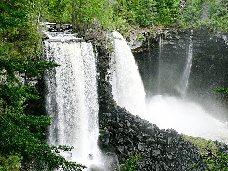
Hendrix Creek Falls is a small to medium cascade on Hendrix Creek in the interior of British Columbia (coordinates 51.9515, -120.6789). The waterfall appears to be in a forested, relatively remote setting and is likely most impressive during spring snowmelt and after heavy rains. Specific published height and official descriptions are limited; the falls may be a single drop or a series of cascades over bedrock.
Why This Waterfall Exists
Hendrix Creek Falls flows over hard volcanic rock, primarily basalt, laid down about 3 million years ago. These resistant rocks form a durable ledge that water cannot easily wear away, creating the falls where softer material downstream has already eroded.
Nearby Falls Worth Visiting
Canim Falls (25 m) lies 11.1 kilometres to the southeast. Also nearby: Mahood Falls (20 m, 11.3 km).
Trail & Hike Details
The Approach
The easy 0.6-km out-and-back trail gains 36 metres of elevation on the way to the falls.
Trail Description
Detailed, official trail descriptions are not readily available for Hendrix Creek Falls. The approach may be via an unmarked or lightly used footpath from a road or creek crossing. Trails in the area are likely to be narrow, rooted, and potentially steep in places. Expect limited signage and possibly route-finding through forested terrain. If you cannot find a maintained trail, be prepared for bushwhacking and route-finding skills.
What to Expect
Expect a forested, possibly remote setting with mixed conifer stands and wet, mossy rock near the creek. Water flow may be highly seasonal: highest in spring (snowmelt) and after heavy rain, lower in late summer and fall. There are likely slick rocks, steep banks and limited formal viewing platforms. Cell service may be unreliable or absent.
Accessibility
The trail is short and relatively flat, but the surface may be uneven. Contact the managing agency for accessibility details.
Frequently Asked Questions
🐶 Are Dogs Allowed at Hendrix Creek Falls?
❌ Dogs are not allowed
Are There Any Fees or Permits Required?
🆖 No fees required
🏊 Is There Swimming at Hendrix Creek Falls?
❌ Swimming is not allowed
When to Visit
Late spring (snowmelt) for highest flows and dramatic water; early summer for good access and pleasant weather. Late summer may have lower flows but easier access. Winter access may be limited or unsafe due to snow and ice.
Seasonal Access
The best time to visit is Spring, Summer, and Fall. Winter access may be limited. Check with the managing park or local authority for current conditions.
Safety Information
• Hazards include slippery rocks, steep or unstable banks, fast-flowing water during high runoff, and limited rescue access. • Weather can change quickly, carry appropriate clothing and check forecasts. • Roads to the trailhead may be rough, gated or seasonally closed, confirm current conditions with local authorities or forestry offices. • Cell phone service may be limited; plan accordingly and inform someone of your itinerary.
Current Water Conditions
Based on a Water Survey of Canada gauge 42.7 km away
2.1 m³/s
Current discharge — how much water is flowing
Lower than usual for this time of year
Based on 60 years of record
0.92 m
Water depth at gauge
7-Day Discharge Trend
What does this mean for your visit?
Flow is lower than usual for this time of year.
About This Gauge
This gauge is on a regional waterway. Conditions at the falls may differ, especially after local rain.
7-Day Flow Outlook
Based on the WSC gauge MCKINLEY CREEK BELOW OUTLET OF MCKINLEY LAKE (43 km away).
Today
Low
2.3 m³/s
4/10Tomorrow
Low
2.2 m³/s
5/10Wed
Low
2.0 m³/s
5/10Thu
Low
2.0 m³/s
5/10Fri
Low
2.1 m³/s
4/10Sat
Moderate
2.1 m³/s
5/10Sun
Moderate
1.8 m³/s
5/10Best window: Tomorrow — low flow, partly cloudy (trip score 5/10).
Best time of year: this gauge typically runs highest from mid April to mid July, peaking in May.
How we calculate this
This is a transparent outlook, not a precise forecast. We take the waterfall's current flow strength (how it ranks against its historical normal for today, from the nearest WSC stream gauge), carry that ranking forward along the gauge's seasonal curve, and nudge it for forecast rain. Confidence is highest for the next day or two and falls further out. Always check official conditions and your own judgment before visiting — high flows can be dangerous.
Weather Forecast
Location & Access
Getting There
The falls are in a remote area of British Columbia near the provided coordinates (51.9515, -120.6789). Expect approach via secondary or logging roads off the nearest provincial highways. Use a detailed topographic map or GPS with the coordinates. Road and trail conditions can change rapidly; a high-clearance vehicle may be required for unpaved access roads and seasonal washouts may occur.
Get Directions on Google MapsParking
Parking information is not well-documented. There may be informal pullouts or small parking areas near the trailhead; parking may be on roadside gravel near a creek crossing. Park safely and avoid blocking gates or access points.
Elevation
998 metres above sea level
Coordinates
51.951505° N, -120.678868° W
Visitor Tips & Gear
• Use the provided coordinates in a GPS or mapping app; bring a topographic map and compass as backup. • Wear sturdy hiking boots with good traction; approaches may be steep and slippery. • Expect limited or no signage, route-finding may be necessary. • Check local forestry or park service advisories for road conditions and closures before you go. • Leave no trace: pack out all trash and avoid disturbing vegetation or streambeds. • Be cautious near the water’s edge, wet rock and currents can be hazardous. • Tell someone your plans and expected return time; cell coverage may be spotty.
As an Amazon Associate, we earn from qualifying purchases.
For this easy 0.6 km trail, lightweight trail shoes and a water bottle are usually sufficient. Sun exposure on the trail makes good sun protection a must in summer.

Columbia Watertight II Rain Jacket
Packs into its own pocket, seam-sealed, and keeps you dry from spray and surprise rain.

Earth Pak Waterproof Dry Bag
Keeps your phone and gear dry when waterfall mist soaks everything else.

Waterproof Phone Pouch (AiRunTech)
Cheap insurance — take photos right next to the falls without killing your phone.

Polarized Sunglasses (Knockaround)
Cuts glare off the water so you actually see the falls — and your photos turn out better too.

Osprey Daylite Daypack
Light, organized, and just the right size for a day hike — fits water, snacks, and layers.

OR Sombriolet Sun Hat
UPF 50+ sun protection with vents so your head doesn't cook on exposed trail sections.
Where to Stay
Browse vacation cabins and private rentals nearby
Unique outdoor stays — tents, yurts, and treehouses
Rent a campervan or RV for your waterfall road trip
Some links are affiliate links. We may earn a commission at no extra cost to you.
Nearby Campground
Paddy Lake Recreation Site
8.7 km away
Additional Information
Nearby Attractions
Specific nearby attractions are not well-documented for this exact coordinate. The falls are in the general interior/central BC region where provincial parks, rivers and scenic drives may be found, check regional maps for nearby provincial parks, trails, and river access points.
Wildlife
Typical interior BC wildlife may be present: black bears, deer, small mammals, and a variety of birds. Use standard wildlife safety practices (store food securely, make noise on trails, carry bear spray where recommended).
Nearby Waterfalls
Writing about Hendrix Creek Falls? Embed this waterfall on your site for free.