Mahood Falls
British Columbia • Wells Gray Park • 20 m
By Armen Suny · Last verified Jun 2026
Difficulty
Easy
Trail Length
2.4 km
Trail Type
Out And Back
Elevation Gain
50 m
About Mahood Falls
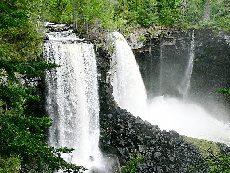
Mahood Falls is a waterfall in Wells Gray Provincial Park located on the Canim River between Canim Lake and Mahood Lake and northeast of 100 Mile House, British Columbia, Canada. The waterfall is 30 m (98 ft) high.
The Setting
Mahood Falls sits at 775 metres within Wells Gray Park, in the hills of British Columbia. The falls drop 20 metres.
Why This Waterfall Exists
Mahood Falls flows over layered sedimentary rock laid down about 145-252 million years ago. Over time, the stream has worn through these layers at different rates, creating a 65-foot drop that forms the waterfall.
Trail & Hike Details
The Approach
The easy 2.4-km out-and-back trail gains 50 metres of elevation on the way to the falls.
Trail Description
A short, generally flat walk from the parking area leads to one or more viewing points above or beside the cascade. The trail is through mixed forest and may include roots, uneven ground and a short set of steps or a small boardwalk in places. The immediate approach is typically short enough for most visitors, but surfaces can be wet and slippery near the water.
What to Expect
The falls drop 20 metres over layered sedimentary rock.
Accessibility
The trail is not wheelchair accessible. Uneven terrain and elevation changes require steady footing.
Frequently Asked Questions
🐶 Are Dogs Allowed at Mahood Falls?
❌ Dogs are not allowed
Are There Any Fees or Permits Required?
🆖 No fees required
🏊 Is There Swimming at Mahood Falls?
❌ Swimming is not allowed
When to Visit
Spring for highest flows and meltwater; late spring to early summer for good water volume and greener surroundings. Summer and early fall are comfortable for weather and hiking; fall provides good color. Winter visits are possible but access and conditions may be difficult or require snow travel skills.
Seasonal Access
The best time to visit is Spring, Summer, Fall, and Winter. Check with Wells Gray Park for current conditions.
Safety Information
Hazards include slippery rocks and trails near the water, cold and fast-moving water, changing weather, and wildlife encounters (including bears). Do not approach cliff edges or attempt to climb wet rock faces. Carry appropriate clothing, let someone know your plans if travelling to remote areas, and check local park advisories before visiting.
Current Water Conditions
Based on a Water Survey of Canada gauge 38.5 km away
0.4 m³/s
Current discharge — how much water is flowing
Much lower than usual for this time of year
Based on 26 years of record
3.59 m
Water depth at gauge
7-Day Discharge Trend
What does this mean for your visit?
Flow is well below normal for this time of year, so the waterfall may be a trickle.
About This Gauge
This gauge is on a regional waterway. Conditions at the falls may differ, especially after local rain.
7-Day Flow Outlook
Based on the WSC gauge BRIDGE CREEK BELOW DEKA CREEK (39 km away).
Today
Barely Flowing
0.4 m³/s
3/10Tomorrow
Barely Flowing
0.4 m³/s
4/10Tue
Barely Flowing
0.4 m³/s
5/10Wed
Barely Flowing
0.4 m³/s
4/10Thu
Barely Flowing
0.4 m³/s
4/10Fri
Low
0.4 m³/s
3/10Sat
Low
0.4 m³/s
4/10Best window: Tue — barely flowing flow, sunny (trip score 5/10).
Best time of year: this gauge typically runs highest from mid April to mid July, peaking in May.
How we calculate this
This is a transparent outlook, not a precise forecast. We take the waterfall's current flow strength (how it ranks against its historical normal for today, from the nearest WSC stream gauge), carry that ranking forward along the gauge's seasonal curve, and nudge it for forecast rain. Confidence is highest for the next day or two and falls further out. Always check official conditions and your own judgment before visiting — high flows can be dangerous.
Weather Forecast
Location & Access
Getting There
Mahood Falls lies at the outlet of Mahood Lake in the Wells Gray Provincial Park area (coordinates: 51.8666, -120.5894). From the town of Clearwater, BC, follow Clearwater Valley Road (Highway 24) toward Wells Gray Park and take the turn onto Mahood Lake Road. The falls are reached from a short access road/parking area off Mahood Lake Road. Roads in the area may be paved or unpaved and conditions can change seasonally, check local road reports and park information before travelling.
Get Directions on Google MapsParking
Small parking area or roadside pullout near the trailhead; parking is limited and may be unpaved. Park considerately and do not block access roads.
Elevation
775 metres above sea level
Coordinates
51.866622° N, -120.589436° W
Land Management
Managed by Government of British Columbia
Visitor Tips & Gear
• Wear sturdy footwear, rocks and paths near the falls can be slippery. • Bug spray is useful in spring/summer. • Leave no trace, pack out all trash. • Be cautious near the water’s edge; currents can be stronger than they appear. • Check local road and park conditions before visiting, especially in shoulder seasons when access roads may be rough or closed. • If visiting in winter, be prepared for snow/ice and limited services.
As an Amazon Associate, we earn from qualifying purchases.
This easy 2.4 km hike is straightforward — comfortable trail shoes and plenty of water should do. Icy conditions are common in winter — traction cleats are a smart addition.

Columbia Watertight II Rain Jacket
Packs into its own pocket, seam-sealed, and keeps you dry from spray and surprise rain.

Earth Pak Waterproof Dry Bag
Keeps your phone and gear dry when waterfall mist soaks everything else.

Waterproof Phone Pouch (AiRunTech)
Cheap insurance — take photos right next to the falls without killing your phone.

Kahtoola MICROspikes
Cult-favorite traction cleats that grip ice and wet rock — essential for winter waterfall hikes.

Polarized Sunglasses (Knockaround)
Cuts glare off the water so you actually see the falls — and your photos turn out better too.

Osprey Daylite Daypack
Light, organized, and just the right size for a day hike — fits water, snacks, and layers.
Where to Stay
Browse vacation cabins and private rentals nearby
Unique outdoor stays — tents, yurts, and treehouses
Rent a campervan or RV for your waterfall road trip
Some links are affiliate links. We may earn a commission at no extra cost to you.
Nearby Campground
Mahood Lake Campground
4.6 km away
Additional Information
Nearby Attractions
Wells Gray Provincial Park attractions such as Mahood Lake, Canim Falls, and the larger Wells Gray waterfall sites (e.g., Helmcken Falls) are in the general region. The nearby area offers hiking, canoeing on Mahood Lake, and scenic drives.
Wildlife
Typical central BC wildlife may be present: black bears, mule deer, moose, birds and small mammals. Maintain distance from wildlife and follow food/storage regulations for the area.
Nearby Waterfalls
Writing about Mahood Falls? Embed this waterfall on your site for free.