Difficulty
Easy
Trail Length
2.6 km
Trail Type
Loop
Elevation Gain
55 m
About Chute du Quatre
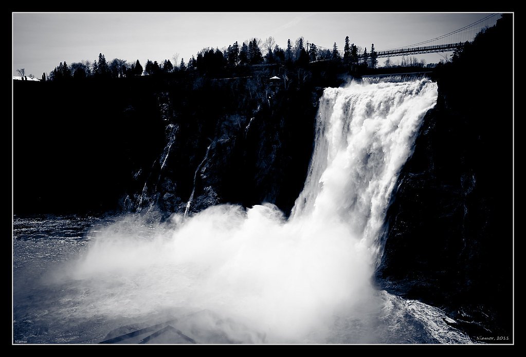
Chute du Quatre is a waterfall feature in the Mauricie region of Quebec, located near the communities of Shawinigan-Sud and Trois-Rivières (coordinates: 46.818, -72.4337). Publicly available, detailed trail and management information for this specific chute is limited. The fall appears to be a natural, forested-site waterfall on a local river or stream and may consist of cascades or a single drop. Exact height and official access points are not confirmed; visitors should verify access with local tourist offices or municipal authorities before visiting.
Why This Waterfall Exists
Chute du Quatre flows over hard crystalline rock laid down over 1.0-1.6 billion years ago. These resistant rocks form a durable ledge that water cannot easily wear away, creating the falls where softer material downstream has already eroded.
Trail & Hike Details
The Approach
The easy 2.6-km loop trail gains 55 metres of elevation on the way to the falls.
Trail Description
There is no widely published, maintained trail description for Chute du Quatre available in major hiking databases. Reaching the fall may involve a short walk from a nearby road or an informal/unmarked path through mixed forest. Trails in the region can be rocky, rooty, and uneven; expect natural, unpaved terrain and limited or no infrastructure (no boardwalks, railings, or formal viewing platforms unless posted on-site).
What to Expect
A natural, forested waterfall setting with variable water flow depending on season. Facilities are unlikely (no guaranteed bathrooms, signage, or staffed ranger presence). Expect slippery rock surfaces near the water, mud after rain or during spring melt, and typical Mauricie-region forest conditions (mixed hardwood and conifer stands). cellphone coverage may be spotty in some spots.
Accessibility
The trail is not wheelchair accessible. Uneven terrain and elevation changes require steady footing.
Frequently Asked Questions
🐶 Are Dogs Allowed at Chute du Quatre?
❌ Dogs are not allowed
Are There Any Fees or Permits Required?
🆖 No fees required
🏊 Is There Swimming at Chute du Quatre?
❌ Swimming is not allowed
When to Visit
Spring (snowmelt) typically offers the highest and most dramatic water flow. Early summer provides milder weather and lower flows. Fall can be excellent for foliage colors but flows may be reduced. Winter visits may show ice formations but can be hazardous due to ice and deep snow, only for experienced winter hikers with appropriate gear.
Seasonal Access
The best time to visit is Spring, Summer, Fall, and Winter. Check with the managing park or local authority for current conditions.
Safety Information
Potential hazards include slippery rocks and falls near the water, strong or cold currents, sudden changes in flow after rainfall or spring melt, unstable banks, and winter ice hazards. There may be no lifeguard or emergency services immediately on site; mobile phone reception can be inconsistent. Wear proper footwear, avoid getting too close to edges, supervise children closely, and do not swim unless you have confirmed it is safe and permitted. If unsure about access or safety, consult local authorities before visiting.
7-Day Flow Outlook
Based on the WSC gauge BATISCAN (RIVIERE) A 3,4 KM EN AVAL DE LA RIVIERE DES ENVIES (26 km away).
Best time of year: this gauge typically runs highest from early April to mid June, peaking in April.
How we calculate this
This is a transparent outlook, not a precise forecast. We take the waterfall's current flow strength (how it ranks against its historical normal for today, from the nearest WSC stream gauge), carry that ranking forward along the gauge's seasonal curve, and nudge it for forecast rain. Confidence is highest for the next day or two and falls further out. Always check official conditions and your own judgment before visiting — high flows can be dangerous.
Know when to go.
Get a free email alert when waterfalls near Shawinigan-Sud hit peak flow. We only send when conditions are worth the trip — no weekly newsletters, no spam.
Weather Forecast
Location & Access
Getting There
Coordinates: 46.818, -72.4337. The site is in the Mauricie region of Quebec, roughly between Shawinigan-Sud and Trois-Rivières. Exact signed trailheads and formal directions are not confirmed in publicly available sources. Access may require driving on local roads or forestry roads; verify route and road conditions locally (municipal offices, regional tourist information, or local hiking resources).
Get Directions on Google MapsParking
No confirmed official parking lot is documented. Parking may be roadside or informal if access is from a secondary road. Visitors should look for posted signage, avoid blocking private driveways, and confirm legal parking with local authorities.
Elevation
107 metres above sea level
Coordinates
46.817953° N, -72.433658° W
Visitor Tips & Gear
1) Contact the Shawinigan or Trois-Rivières tourist offices or local municipality to confirm access, parking, and whether the site is on public or private land. 2) Wear sturdy, grippy footwear and dress for changing weather. 3) Bring a map/GPS device with the coordinates and a portable battery. 4) Do not trespass on private property; follow posted signs. 5) Be cautious around edges and wet rocks; there are likely no guardrails. 6) Leave no trace: pack out all trash. 7) Check for seasonal hazards (ice in winter, high flows in spring).
As an Amazon Associate, we earn from qualifying purchases.
This easy 2.6 km hike is straightforward — comfortable trail shoes and plenty of water should do. Icy conditions are common in winter — traction cleats are a smart addition.

Columbia Watertight II Rain Jacket
Packs into its own pocket, seam-sealed, and keeps you dry from spray and surprise rain.

Earth Pak Waterproof Dry Bag
Keeps your phone and gear dry when waterfall mist soaks everything else.

Waterproof Phone Pouch (AiRunTech)
Cheap insurance — take photos right next to the falls without killing your phone.

Kahtoola MICROspikes
Cult-favorite traction cleats that grip ice and wet rock — essential for winter waterfall hikes.

Polarized Sunglasses (Knockaround)
Cuts glare off the water so you actually see the falls — and your photos turn out better too.

Osprey Daylite Daypack
Light, organized, and just the right size for a day hike — fits water, snacks, and layers.
Where to Stay
Browse vacation cabins and private rentals nearby
Unique outdoor stays — tents, yurts, and treehouses
Rent a campervan or RV for your waterfall road trip
Some links are affiliate links. We may earn a commission at no extra cost to you.
Nearby Campground
Camping Lac et Forêt
5 km away
Additional Information
Nearby Attractions
Shawinigan (La Cité de l'Énergie, local museums), Parc national de la Mauricie (hiking, lakes, more waterfalls), and the historic city of Trois-Rivières are the main regional attractions. Distances and exact travel times vary depending on the final access point to Chute du Quatre.
Wildlife
Typical regional wildlife may include white-tailed deer, beaver, fox, black bear (rare but present in the region), small mammals, and a variety of songbirds and waterfowl. Take normal wildlife precautions: store food securely and maintain distance from large animals.
Cities near Chute du Quatre
Nearby Waterfalls
Writing about Chute du Quatre? Embed this waterfall on your site for free.