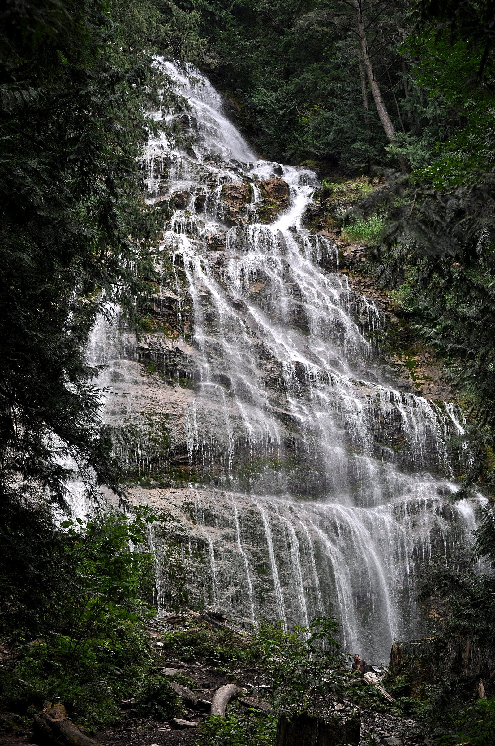
Airplane Basin Falls
By Armen Suny · Last verified Jun 2026
Difficulty
Moderate
Trail Length
12.9 km
Trail Type
Out And Back
Elevation Gain
608 m
About Airplane Basin Falls
Airplane Basin Falls is a relatively remote, lightly visited waterfall on the north side of the Chilliwack region of southwestern British Columbia (approx. coordinates 49.155, -121.6391). The feature appears to be a seasonal to perennial cascade that is most impressive during spring snowmelt and after heavy rains. Access is informal and the route is likely along unmaintained forest/horse/logging trails and rough forest service roads; route-finding and some off-trail travel may be required. Detailed published information is limited, so many specifics (exact height, official trailhead, maintained trail route) are not well documented.
Why This Waterfall Exists
Airplane Basin Falls flows over Chilliwack Group, a layered sedimentary rock layer deposited about 252-419 million years ago. Over time, the stream has worn through these layers at different rates, creating the step that forms the waterfall.
Nearby Falls Worth Visiting
Bridal Veil Falls (122 m) lies 7.9 kilometres to the west. Also nearby: Elk Creek Falls (100 m, 11.9 km) and Foley Lake Falls (20 m, 5.3 km).
Trail & Hike Details
The Approach
The moderate 12.9-km out-and-back trail gains 608 metres of elevation on the way to the falls.
Trail Description
There is no widely published, maintained trail specifically to Airplane Basin Falls. Expect a rough route that may include a short hike from a logging or forest service road, unmarked boot paths, and some bushwhacking. Terrain may be steep in places with loose rocks, roots, and wet/slippery sections near the stream. Visitors should use GPS coordinates, topographic maps, and strong navigation skills. If approaching via forest roads, verify seasonal road conditions and closures before travel.
What to Expect
A secluded cascade in a forested mountain basin. Seasonal flow variance is likely: high flows in spring and after heavy rain, lower flows in late summer. The setting is backcountry, expect minimal to no visitor infrastructure, limited signage, and little to no cell service. Wildlife in the area may include black bears, deer, and various birds; insects (mosquitoes/blackflies) can be numerous in warmer months.
Accessibility
The trail involves steep, uneven terrain with significant elevation change and is not accessible to mobility devices.
Frequently Asked Questions
🐶 Are Dogs Allowed at Airplane Basin Falls?
❌ Dogs are not allowed
Are There Any Fees or Permits Required?
🆖 No fees required
🏊 Is There Swimming at Airplane Basin Falls?
❌ Swimming is not allowed
When to Visit
Late spring (snowmelt) for highest flows and good early-summer access. Summer offers drier roads but reduced flow. Fall can provide good access and scenic colors but flows may be lower. Winter access may be difficult or unsafe due to snow, ice, and road closures.
Seasonal Access
The best time to visit is Spring, Summer, and Fall. Winter access may be limited. Check with the managing park or local authority for current conditions.
Safety Information
Hazards include slippery rocks near the falls, unstable stream banks, sudden high water during spring melt or storms, rough/seasonal logging roads, limited or no cell service, and wildlife encounters. Use caution on steep or loose terrain and avoid cliff edges. Check local conditions and road advisories before travel. Carry appropriate emergency equipment and navigation aids.
Current Water Conditions
19.5 m³/s
Current discharge — how much water is flowing
Much lower than usual for this time of year
Based on 61 years of record
0.85 m
Water depth at gauge
7-Day Discharge Trend
What does this mean for your visit?
Flow is well below normal for this time of year, so the waterfall may be a trickle.
About This Gauge
7-Day Flow Outlook
Based on the WSC gauge CHILLIWACK RIVER ABOVE SLESSE CREEK (6 km away).
Today
Barely Flowing
19 m³/s
4/10Tomorrow
Barely Flowing
19 m³/s
4/10Tue
Barely Flowing
18 m³/s
4/10Wed
Barely Flowing
18 m³/s
4/10Thu
Barely Flowing
20 m³/s
3/10Fri
Barely Flowing
18 m³/s
4/10Sat
Barely Flowing
17 m³/s
4/10Best window: Today — barely flowing flow, partly cloudy (trip score 4/10).
Best time of year: this gauge typically runs highest from late April to late July, peaking in June.
How we calculate this
This is a transparent outlook, not a precise forecast. We take the waterfall's current flow strength (how it ranks against its historical normal for today, from the nearest WSC stream gauge), carry that ranking forward along the gauge's seasonal curve, and nudge it for forecast rain. Confidence is highest for the next day or two and falls further out. Always check official conditions and your own judgment before visiting — high flows can be dangerous.
Know when to go.
Get a free email alert when waterfalls near Chilliwack hit peak flow. We only send when conditions are worth the trip — no weekly newsletters, no spam.
Weather Forecast
Location & Access
Getting There
The falls lie in the Chilliwack area northwest of the town of Chilliwack (approx. 13.7 miles), and are also relatively near the communities of Glacier and Maple Falls. Approaches typically use secondary or logging/forest service roads off the main highways in the valley; these roads may be rough and require high-clearance or 4x4 vehicles. Expect at least a short hike from the nearest reachable road. Exact public trailheads and signed approaches are not well documented in major guidebooks, so bring GPS coordinates and a topo map and be prepared for route-finding.
Get Directions on Google MapsParking
There is likely no developed parking lot. Parking may be informal on a nearby forest road pullout or at a small logging-road clearing. Park off the traveled portion of any road and avoid blocking gates or access. If unsure, use established trailhead or parking areas in the wider Chilliwack/Chilliwack Lake region and confirm local access.
Elevation
1,252 metres above sea level
Coordinates
49.154980° N, -121.639075° W
Visitor Tips & Gear
• Carry a detailed topo map and a GPS with the coordinates (49.155, -121.6391). • Use a high-clearance vehicle for logging/FS roads and check road status locally. • Tell someone your route and expected return time; cell service may be unreliable. • Wear sturdy footwear with good traction; rocks near the falls will be slippery. • Bring insect repellent in spring/summer. • Respect private property and posted closure or no-parking signage. • Avoid approaching the edge of cliffs or riverbanks, banks may be unstable.
As an Amazon Associate, we earn from qualifying purchases.
With 12.9 km and 608 m of elevation gain, sturdy boots and trekking poles will help on this moderate trail. Sun exposure on the trail makes good sun protection a must in summer.

Columbia Watertight II Rain Jacket
Packs into its own pocket, seam-sealed, and keeps you dry from spray and surprise rain.

Earth Pak Waterproof Dry Bag
Keeps your phone and gear dry when waterfall mist soaks everything else.

Waterproof Phone Pouch (AiRunTech)
Cheap insurance — take photos right next to the falls without killing your phone.

Timberland Euro Sprint Mid Waterproof
Trusted waterproof boot with premium leather and grippy rubber sole — reliable on rocky, wet trails.

TrailBuddy Trekking Poles
Lightweight aluminum, cork grips, and flip-locks that actually hold — a best-seller for good reason.

Sawyer Squeeze Water Filter
The backcountry standard — filters 99.9% of bacteria and weighs just 3 oz.
Where to Stay
Browse vacation cabins and private rentals nearby
Unique outdoor stays — tents, yurts, and treehouses
Rent a campervan or RV for your waterfall road trip
Some links are affiliate links. We may earn a commission at no extra cost to you.
Nearby Campground
Airplane Creek
4.3 km away
Nearby Hot Springs
Hot springs near Chilliwack, British Columbia
Baker Hot Spring
Baker Hot Spring emerges at 108 degrees Fahrenheit on US Forest Service land in Mt. Baker National Forest, flowing 59.5 degrees...
Dorr Fumarole Field
Dorr Fumarole Field reaches 194 degrees at 8,168 feet elevation on Mount Baker's active volcanic slopes, producing superheated ...

Sherman Crater Fumaroles
Sherman Crater Fumaroles register 266 degrees Fahrenheit at 9,463 feet elevation within the active volcanic crater atop Mount B...
Looking for a soak after your hike? Explore more hot springs near Chilliwack, British Columbia on SoakingSprings.
Explore British Columbia springsAdditional Information
Nearby Attractions
Chilliwack River Valley, Chilliwack Lake Provincial Park, Mount Cheam viewpoints, hiking trails and backcountry routes in the Hozameen/Skagit-Slesse areas. The town of Chilliwack offers services and trailheads for more developed hikes.
Wildlife
Black bears, cougars (rare), deer, small mammals, and a variety of birds. Mosquitoes and blackflies are common in spring/summer. Be bear-aware and store food properly.
Cities near Airplane Basin Falls
Nearby Waterfalls
Writing about Airplane Basin Falls? Embed this waterfall on your site for free.