Difficulty
Moderate
Trail Type
Out And Back
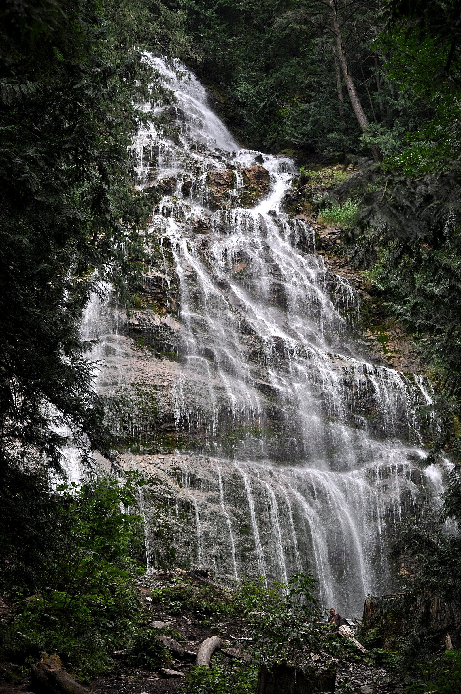
About McNulty Falls
McNulty Falls is a forested, likely low- to mid-height cascade located in the Chilliwack region of British Columbia (approx. coordinates 49.2371, -121.6703). The falls sit in a narrow valley and are best known to local hikers and off-road visitors rather than being a heavily developed tourist site. Access appears to involve unpaved roads and a short, unmaintained footpath rather than a formal park trail. Flow and appearance are seasonal and typically highest in spring and after heavy rain.
Why This Waterfall Exists
McNulty Falls flows over hard volcanic rock laid down about 252-419 million years ago. These resistant rocks form a durable ledge that water cannot easily wear away, creating the falls where softer material downstream has already eroded.
Nearby Falls Worth Visiting
Bridal Veil Falls (122 m) lies 8.0 kilometres to the southwest. Also nearby: Elk Creek Falls (100 m, 15.1 km) and Foley Lake Falls (20 m, 13.8 km).
Trail & Hike Details
Trail Description
The route to McNulty Falls is typically an unmarked, informal path departing from a roadside pullout or the end of a rough spur road. Expect a short bushwhack or steep, rooty sections and potentially muddy or slippery surfaces. The trail is not maintained, may cross small streams, and offers limited constructed viewpoints or railings. Navigation may require a GPS with the provided coordinates or a topographic map.
What to Expect
A forested setting with a waterfall in a narrow ravine. Water flow varies by season, highest in spring and after heavy rain, reduced in late summer. There are likely rocks and roots underfoot, uneven banks, and no formal safety infrastructure. Cell reception may be limited. Wildlife such as deer, small mammals, and possibly black bears or cougars may be present in the area.
Accessibility
The trail is not wheelchair accessible. Uneven terrain and elevation changes require steady footing.
Frequently Asked Questions
🐶 Are Dogs Allowed at McNulty Falls?
❌ Dogs are not allowed
Are There Any Fees or Permits Required?
🆖 No fees required
🏊 Is There Swimming at McNulty Falls?
❌ Swimming is not allowed
When to Visit
Spring (snowmelt and seasonal rains) for highest flows and dramatic water, and early fall after rains. Summer can be lower-flow but warmer and drier for access. Winter may be icy or have snow on approach roads.
Seasonal Access
The best time to visit is Spring, Summer, and Fall. Winter access may be limited. Check with the managing park or local authority for current conditions.
Safety Information
Hazards include unstable, slippery rocks and banks, steep or unmaintained terrain, variable water flow, cold water temperatures, limited or no cell reception, and potential wildlife encounters (bears, cougars). Road access may be rough and require high-clearance or 4WD, especially when wet. There are no formal safety features or lifeguards, exercise caution, avoid getting too close to edges, and do not climb on wet rocks.
7-Day Flow Outlook
Based on the WSC gauge FRASER RIVER NEAR AGASSIZ (9 km away).
Best time of year: this gauge typically runs highest from early May to early August, peaking in June.
How we calculate this
This is a transparent outlook, not a precise forecast. We take the waterfall's current flow strength (how it ranks against its historical normal for today, from the nearest WSC stream gauge), carry that ranking forward along the gauge's seasonal curve, and nudge it for forecast rain. Confidence is highest for the next day or two and falls further out. Always check official conditions and your own judgment before visiting — high flows can be dangerous.
Know when to go.
Get a free email alert when waterfalls near Chilliwack hit peak flow. We only send when conditions are worth the trip — no weekly newsletters, no spam.
Weather Forecast
Location & Access
Getting There
From Chilliwack drive toward the eastern foothills and backcountry logging roads in the general area of the provided coordinates. Final access usually requires driving on unpaved or gravel forest roads and a short walk on an unmaintained trail or game trail to the creek. 4WD or high-clearance vehicle may be useful in wet conditions; local maps/GIS and up-to-date road-status information are recommended before attempting.
Get Directions on Google MapsParking
Limited roadside parking at the informal trailhead or pullout. There is no developed parking lot or facilities; park well off the road and avoid blocking gates or private driveways. Expect uneven ground and possible mud.
Elevation
250 metres above sea level
Coordinates
49.237079° N, -121.670258° W
Visitor Tips & Gear
1) Use a reliable map or GPS and bring the coordinates. 2) Wear sturdy, waterproof footwear with good traction; expect slippery rocks. 3) Check current road conditions and closures before driving on unpaved forest roads. 4) Park well off the travel lane and avoid blocking gates or access roads. 5) Pack out all trash and respect any private property signs. 6) Let someone know your route and expected return time; cell signal may be unreliable. 7) Bring insect repellent in summer and be bear-aware (make noise, carry bear spray where legal).
Where to Stay
Browse vacation cabins and private rentals nearby
Unique outdoor stays — tents, yurts, and treehouses
Rent a campervan or RV for your waterfall road trip
Some links are affiliate links. We may earn a commission at no extra cost to you.
Nearby Campground
Jones Lake West Recreation Area
4.8 km away
Nearby Hot Springs
Hot springs near Chilliwack, British Columbia
Baker Hot Spring
Baker Hot Spring emerges at 108 degrees Fahrenheit on US Forest Service land in Mt. Baker National Forest, flowing 59.5 degrees...
Dorr Fumarole Field
Dorr Fumarole Field reaches 194 degrees at 8,168 feet elevation on Mount Baker's active volcanic slopes, producing superheated ...

Sherman Crater Fumaroles
Sherman Crater Fumaroles register 266 degrees Fahrenheit at 9,463 feet elevation within the active volcanic crater atop Mount B...
Looking for a soak after your hike? Explore more hot springs near Chilliwack, British Columbia on SoakingSprings.
Explore British Columbia springsAdditional Information
Nearby Attractions
The falls are in the broader Chilliwack/backcountry region; nearby destinations commonly visited by visitors to the area include Chilliwack valley trails, local lakes, and provincial parks in the region. Specific nearby developed attractions and services are in the Chilliwack area (town services, visitor information, and trailheads).
Wildlife
Typical local wildlife may include black bears, deer, small mammals, raptors, and other forest species. Take standard precautions for wildlife encounters and store food securely.
Cities near McNulty Falls
Nearby Waterfalls
Writing about McNulty Falls? Embed this waterfall on your site for free.