
Photo Credits (5)
Difficulty
Moderate
Trail Length
2.4 miles
Trail Type
Out And Back
Elevation Gain
350 ft
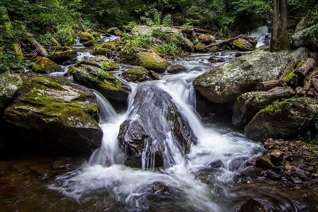
About Wilson Falls
Wilson Falls is a lesser-known waterfall in Georgia that rewards visitors with a peaceful, picture-perfect setting tucked into surrounding woods. Because it doesn’t draw large crowds, the falls are a great pick for hikers and photographers looking for a quiet spot to enjoy cascading water and forest ambiance. The most common access is via a moderate out-and-back hike of about 2.4 miles with roughly 350 feet of elevation gain, making it a doable half-day outing for most active hikers. If you’re planning to camp nearby, Wildcat Creek Campground #2 Upper is roughly 3.23 km away and provides a convenient base for an overnight stay before or after visiting the falls.
The Setting
Wilson Falls sits at 1,965 feet along the Tallulah River, in the hills of Georgia.
Nearby Falls Worth Visiting
Anna Ruby Falls (153 ft) lies 7.6 miles to the southwest.
Trail & Hike Details
The Approach
The moderate 2.4-mile out-and-back trail gains 350 feet of elevation on the way to the falls.
Trail Description
Route: 2.4-mile out-and-back (round-trip). Elevation gain: approximately 350 feet. Difficulty: moderate. Trail type: out-and-back. Specific USFS trail surface, grade, and class data are not available for this route; use appropriate footwear and expect typical forest-trail conditions. Wildcat Creek Campground #2 Upper lies about 3.23 km from the trailhead for nearby camping.
What to Expect
Visitors can expect a peaceful natural setting with a small waterfall surrounded by forest. The area may be less crowded compared to other popular waterfalls in Georgia.
Accessibility
The trail is not wheelchair accessible. Uneven terrain and elevation changes require steady footing.
Frequently Asked Questions
🐶 Are Dogs Allowed at Wilson Falls?
❌ Dogs are not allowed
Are There Any Fees or Permits Required?
🆖 No fees required
🏊 Is There Swimming at Wilson Falls?
❌ Swimming is not allowed
When to Visit
Spring and fall are typically the best times to visit, as the waterfall may have better flow during these seasons. Summer can also be enjoyable, but the flow may be reduced.
Seasonal Access
The best time to visit is Spring, Summer, and Fall. Winter access may be limited.
Safety Information
Visitors should be cautious of slippery rocks near the waterfall and uneven terrain on the trail. Check weather conditions before visiting, as rain can make the trail more hazardous.
Current Water Conditions
101 ft³/s
Current discharge — how much water is flowing
About average for this time of year
Based on 61 years of record
2.18 ft
Water depth at gauge
7-Day Discharge Trend
What does this mean for your visit?
Flow is about average for this time of year.
About This Gauge
This gauge is on a nearby waterway and may not reflect exact conditions at the falls.
7-Day Flow Outlook
Based on the USGS gauge TALLULAH RIVER NEAR CLAYTON, GA (10 km away).
Today
Roaring
115 cfs
6/10Tomorrow
Roaring
124 cfs
6/10Tue
Roaring
126 cfs
6/10Wed
Roaring
124 cfs
6/10Thu
Roaring
111 cfs
9/10Fri
Roaring
109 cfs
6/10Sat
Roaring
110 cfs
6/10Best window: Thu — roaring flow, sunny (trip score 9/10).
Best time of year: this gauge typically runs highest from mid February to mid April, peaking in March.
How we calculate this
This is a transparent outlook, not a precise forecast. We take the waterfall's current flow strength (how it ranks against its historical normal for today, from the nearest USGS stream gauge), carry that ranking forward along the gauge's seasonal curve, and nudge it for forecast rain. Confidence is highest for the next day or two and falls further out. Always check official conditions and your own judgment before visiting — high flows can be dangerous.
Know when to go.
Get a free email alert when waterfalls near Tiger hit peak flow. We only send when conditions are worth the trip — no weekly newsletters, no spam.
Weather Forecast
Location & Access
Getting There
Wilson Falls is located in Georgia, but specific directions to the trailhead or parking area are not well-documented. Visitors are advised to consult local maps or trail resources for accurate guidance.
Get Directions on Google MapsParking
Parking availability is unclear. Visitors should prepare for limited parking options and check local resources for updates.
Elevation
1,965 feet above sea level
Coordinates
34.818149° N, -83.595170° W
Visitor Tips & Gear
Bring a map or GPS device as the trail and access points may not be well-marked. Wear sturdy footwear and be prepared for potential uneven terrain.
As an Amazon Associate, we earn from qualifying purchases.
With 2.4 miles and 350 ft of elevation gain, sturdy boots and trekking poles will help on this moderate trail. Sun exposure on the trail makes good sun protection a must in summer.

Polarized Sunglasses (Knockaround)
Cuts glare off the water so you actually see the falls — and your photos turn out better too.

Columbia Watertight II Rain Jacket
Packs into its own pocket, seam-sealed, and keeps you dry from spray and surprise rain.

Earth Pak Waterproof Dry Bag
Keeps your phone and gear dry when waterfall mist soaks everything else.

Waterproof Phone Pouch (AiRunTech)
Cheap insurance — take photos right next to the falls without killing your phone.

Timberland Euro Sprint Mid Waterproof
Trusted waterproof boot with premium leather and grippy rubber sole — reliable on rocky, wet trails.

TrailBuddy Trekking Poles
Lightweight aluminum, cork grips, and flip-locks that actually hold — a best-seller for good reason.
Where to Stay

Holiday Inn Express & Suites Helen by IHG

Sylvan Valley Lodge and Cellars

Mountain Aire Cottages, Inn & Glamping

Black Forest Bed & Breakfast
Browse vacation cabins and private rentals nearby
Unique outdoor stays — tents, yurts, and treehouses
Rent a campervan or RV for your waterfall road trip
Some links are affiliate links. We may earn a commission at no extra cost to you.
Nearby Campground
Wildcat Creek Campground #2 Upper
2 miles away · 0 sites
CLOSURE DUE TO WINTER WEATHER--JANUARY 14, 2022 storms have damaged the West Wildcat Road to not allow safe vehicle access to the campgrounds.Wildcat 2 Campground is closed. Cannot access with vehicle to clean COVID standards.Although the winding road leading to the campground is not trailer or RV friendly, the payoff of landing a night in this environment is pure delight. These developed tent camping only campgrounds are buried deep in the North Georgia Mountains west of Lake Burton and along th
Book on Recreation.govAdditional Information
Nearby Attractions
Other waterfalls and hiking trails in Georgia may be nearby, but specific attractions close to Wilson Falls are not documented.
Wildlife
The area may feature typical Georgia wildlife such as birds, deer, and small mammals. Visitors should be cautious of snakes and other potential hazards.
Cities near Wilson Falls
Nearby Waterfalls
Other waterfalls named Wilson Falls
2 other waterfalls share this name across the U.S.
Writing about Wilson Falls? Embed this waterfall on your site for free.