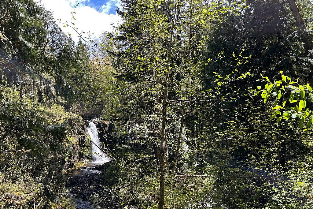
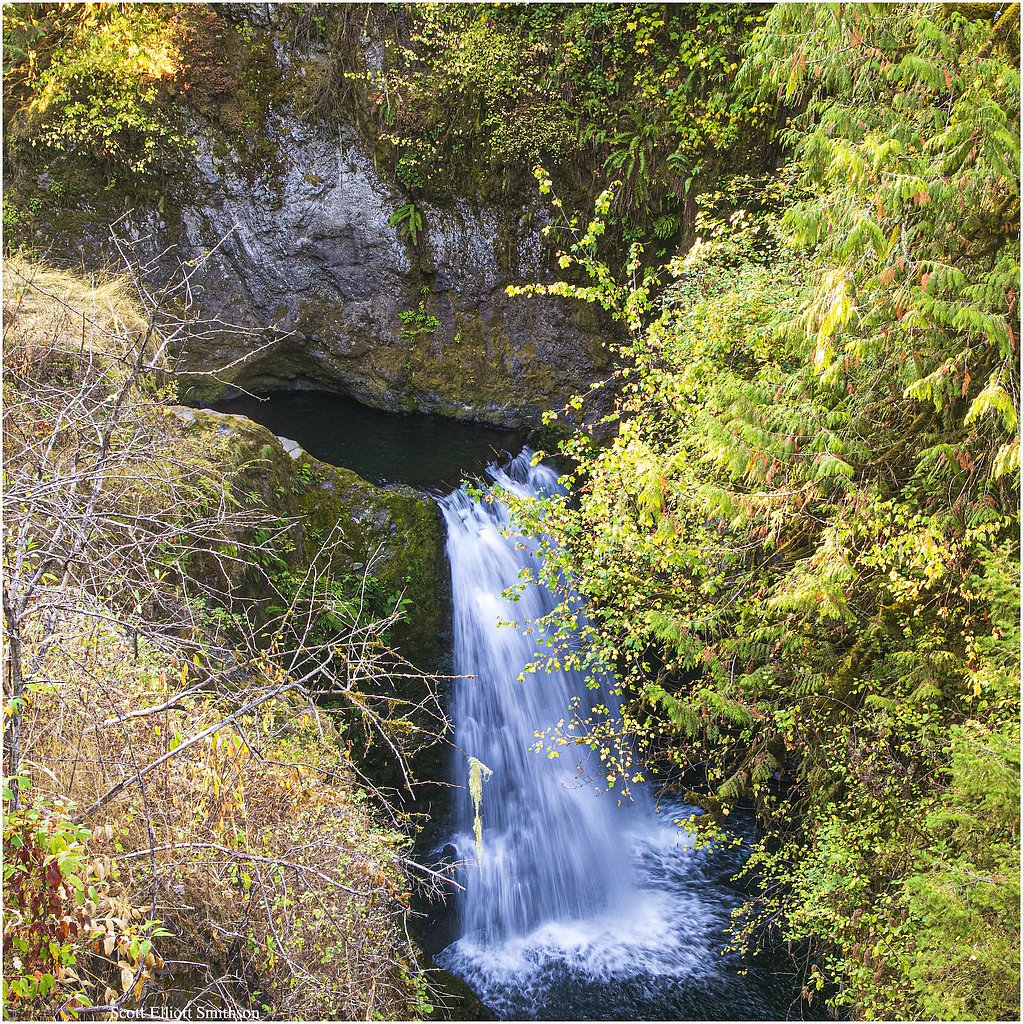
Wildcat Falls
By Armen Suny · Last verified May 2026
Difficulty
Moderate
Trail Length
4.5 miles
Trail Type
Out And Back
Elevation Gain
800 ft
About Wildcat Falls
Wildcat Falls is a scenic Washington waterfall tucked into a forested ravine where water tumbles over rocky ledges to create a peaceful, photogenic setting. The outing is best known for its quiet atmosphere and classic Pacific Northwest evergreens, making it a lovely half-day trip for hikers and photographers alike. The route to the falls is an out-and-back of about 4.5 miles round-trip with roughly 800 feet of elevation gain and is generally rated moderate — expect steady uphill sections that reward you with the sound and spray of the falls at the end. The trail weaves through dense forest and can be especially lush and mossy after wet weather; surfaces vary with seasonal conditions, so waterproof shoes and traction can be helpful. If you want to camp nearby, the closest developed option is Big Creek Campground in Gifford Pinchot National Forest, approximately 26.3 km (about 16 miles) away, making Wildcat Falls a great day hike from that basecamp.
The Setting
Wildcat Falls sits at 1,007 feet along the Ohop Creek, in the foothills of Washington.
Trail & Hike Details
The Approach
The moderate 4.5-mile out-and-back trail gains 800 feet of elevation on the way to the falls.
Trail Description
Out-and-back trail, 4.5 miles round-trip, 800 feet cumulative elevation gain; rated moderate. The route follows a well-defined forest trail through dense timber with steady climbs rather than technical obstacles. Trail tread conditions vary with weather—sections may be muddy, slippery, or root- and rock-strewn after rain—so plan for variable footing. No USFS trail number is provided in the available listing; prepare for typical single-track forest hiking and moderate grades rather than Class 3/4 scrambling.
What to Expect
Dogs are welcome.
Accessibility
The trail is not wheelchair accessible. Uneven terrain and elevation changes require steady footing.
Frequently Asked Questions
🐶 Are Dogs Allowed at Wildcat Falls?
✅ Dogs are allowed
Are There Any Fees or Permits Required?
🤑 Fee: $5.00
Permit required
A Northwest Forest Pass or equivalent is required for parking at the trailhead.
🏊 Is There Swimming at Wildcat Falls?
❌ Swimming is not allowed
When to Visit
Spring and early summer are ideal times to visit, as the waterfall is typically at its fullest due to snowmelt. Fall offers beautiful foliage, while winter may bring snow and ice, making access more challenging.
Seasonal Access
The best time to visit is Spring, Summer, Fall, and Winter.
Safety Information
Visitors should be cautious of slippery rocks near the falls and stay on marked trails to avoid accidents. Check weather conditions before visiting, as rain or snow can make the trail more hazardous.
Current Water Conditions
8 ft³/s
Current discharge — how much water is flowing
Much lower than usual for this time of year
Based on 69 years of record
1.65 ft
Water depth at gauge
7-Day Discharge Trend
What does this mean for your visit?
Flow is well below normal for this time of year, so the waterfall may be a trickle.
About This Gauge
7-Day Flow Outlook
Based on the USGS gauge OHOP CREEK NEAR EATONVILLE, WA (3 km away).
Today
Barely Flowing
8 cfs
3/10Tomorrow
Low
8 cfs
3/10Sat
Low
8 cfs
4/10Sun
Low
7 cfs
4/10Mon
Barely Flowing
8 cfs
4/10Tue
Barely Flowing
7 cfs
5/10Wed
Barely Flowing
7 cfs
3/10Best window: Tue — barely flowing flow, partly sunny (trip score 5/10).
Best time of year: this gauge typically runs highest from mid December to late January, peaking in January.
How we calculate this
This is a transparent outlook, not a precise forecast. We take the waterfall's current flow strength (how it ranks against its historical normal for today, from the nearest USGS stream gauge), carry that ranking forward along the gauge's seasonal curve, and nudge it for forecast rain. Confidence is highest for the next day or two and falls further out. Always check official conditions and your own judgment before visiting — high flows can be dangerous.
Know when to go.
Get a free email alert when waterfalls near Eatonville hit peak flow. We only send when conditions are worth the trip — no weekly newsletters, no spam.
Weather Forecast
Location & Access
Getting There
Wildcat Falls is located within the Mount Baker-Snoqualmie National Forest in Washington. Access is typically via forest roads, and visitors should check road conditions before traveling.
Get Directions on Google MapsParking
Parking is available at a nearby trailhead, but spaces may be limited during peak seasons. Visitors should plan to arrive early to secure a spot.
Elevation
1,007 feet above sea level
Coordinates
46.881771° N, -122.241780° W
Visitor Tips & Gear
Wear sturdy hiking shoes, as the trail can be uneven or muddy. Bring plenty of water and snacks, and consider visiting early in the day to avoid crowds. Check weather and trail conditions before heading out.
As an Amazon Associate, we earn from qualifying purchases.
With 4.5 miles and 800 ft of elevation gain, sturdy boots and trekking poles will help on this moderate trail. Icy conditions are common in winter — traction cleats are a smart addition.

Columbia Watertight II Rain Jacket
Packs into its own pocket, seam-sealed, and keeps you dry from spray and surprise rain.

Earth Pak Waterproof Dry Bag
Keeps your phone and gear dry when waterfall mist soaks everything else.

Waterproof Phone Pouch (AiRunTech)
Cheap insurance — take photos right next to the falls without killing your phone.

Timberland Euro Sprint Mid Waterproof
Trusted waterproof boot with premium leather and grippy rubber sole — reliable on rocky, wet trails.

TrailBuddy Trekking Poles
Lightweight aluminum, cork grips, and flip-locks that actually hold — a best-seller for good reason.

Kahtoola MICROspikes
Cult-favorite traction cleats that grip ice and wet rock — essential for winter waterfall hikes.
Where to Stay

Mountain Meadows Inn & Chalet Suites

Mt Rainier Way Bedroom with Private Full Bath

Mt Rainier Retreat 7 Mi to Park Entrance!

Guppies Lakehouse-Prvt. Lake Acc, Close to Rainier
Browse vacation cabins and private rentals nearby
Unique outdoor stays — tents, yurts, and treehouses
Rent a campervan or RV for your waterfall road trip
Some links are affiliate links. We may earn a commission at no extra cost to you.
Nearby Campground
Big Creek (Gifford Pinchot National Forest, WA)
16.3 miles away · 29 sites
Overview Situated in the vicinity of majestic Mount Rainier, Big Creek is a family campground nestled among Douglas firs, hemlock, alders and maples. The lush vegetation offers plenty of privacy between sites. The sites at Big Creek form a loop, with only a handful of sites sitting along the banks of Big Creek. Open from mid-May through late September, Big Creek provides an alternative to the campgrounds at Mount Rainier National Park, which can get very crowded during the summer. Recreation Angl
Book on Recreation.govNearby Hot Springs
Hot springs near Eatonville, Washington

Mt Rainier Fumaroles
Mount Rainier fumaroles reach 162 degrees at 14,217 feet elevation, emerging 154.8 degrees above ambient at Washington's highes...

Longmire Mineral Springs
Longmire Mineral Springs flows at 77 degrees within Mount Rainier National Park at 2,758 feet elevation, emerging 31.9 degrees ...
Green River Soda Spring
Green River Soda Spring produces 86-degree carbonated water at 1,644 feet elevation, flowing 37.5 degrees above ambient tempera...

Mt St Helens Fumaroles
Mount St. Helens fumaroles reach 190 degrees at 6,906 feet elevation on the crater rim, emerging 159.1 degrees above ambient in...

Ohanapecosh Hot Springs
Ohanapecosh Hot Springs flows at 122 degrees within Mount Rainier National Park at 1,920 feet elevation, emerging 74.5 degrees ...
Packwood Hot Spring
Packwood Hot Spring flows at 100 degrees at 1,002 feet elevation in the lower Cascade foothills near Morton, emerging 49.8 degr...
Looking for a soak after your hike? Explore more hot springs near Eatonville, Washington on SoakingSprings.
Explore Washington springsAdditional Information
Nearby Attractions
Other nearby attractions include the Mount Baker-Snoqualmie National Forest and various hiking trails in the area.
Wildlife
The area is home to a variety of wildlife, including birds, deer, and small mammals. Visitors should be cautious of bears and other larger animals.
Cities near Wildcat Falls
Nearby Waterfalls
Other waterfalls named Wildcat Falls
2 other waterfalls share this name across the U.S.
Writing about Wildcat Falls? Embed this waterfall on your site for free.