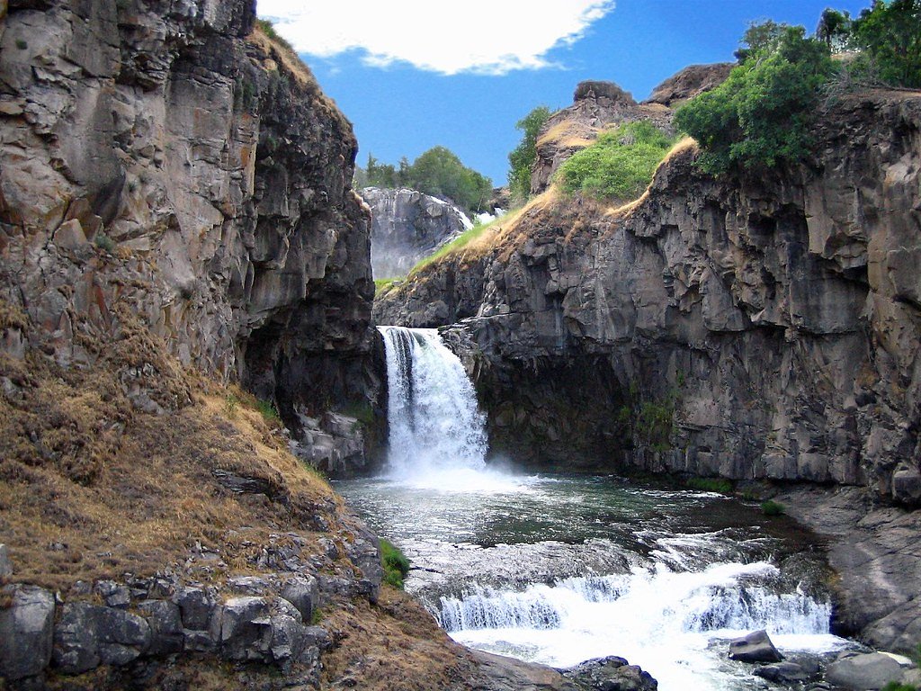
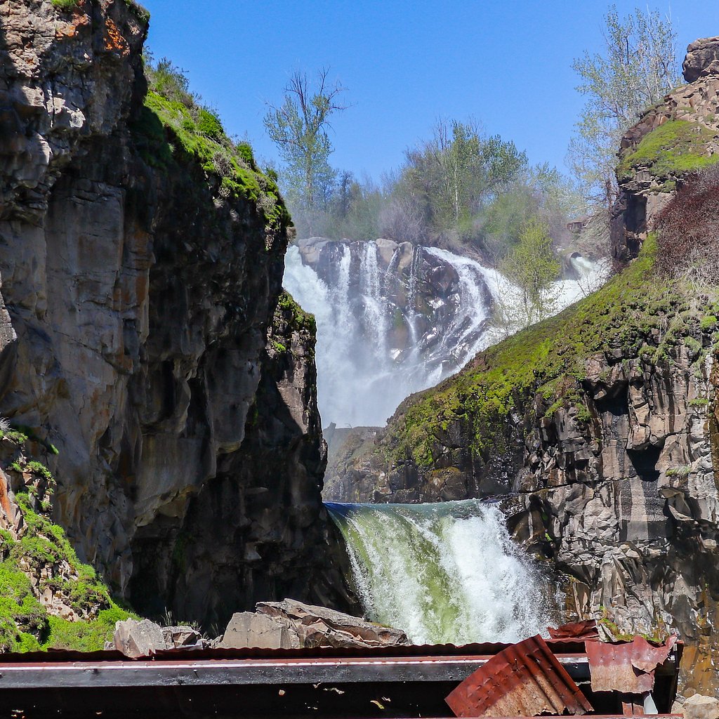
White River Falls
Oregon • 90 ft
By Armen Suny · Last verified Mar 2026
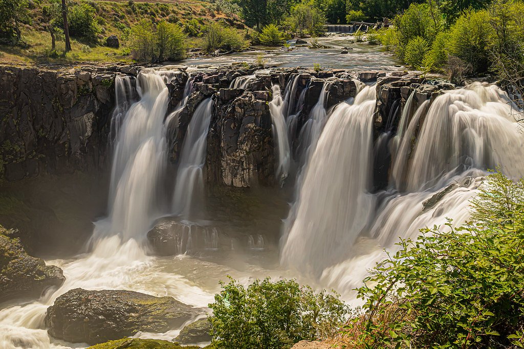
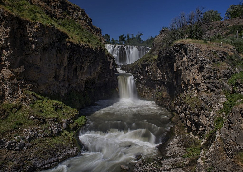
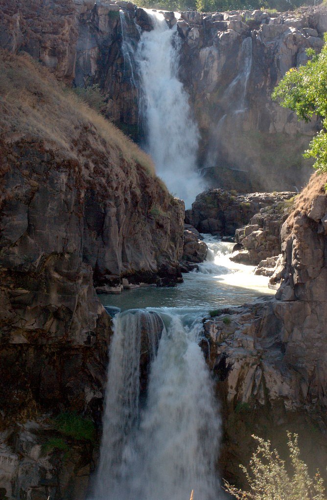


Photo Credits (5)
Difficulty
Moderate
Trail Length
0.8 miles
Trail Type
Out And Back
Elevation Gain
200 ft
About White River Falls
White River Falls is a stunning waterfall located in White River Falls State Park in north-central Oregon. The falls cascade over a basalt cliff in two main tiers, creating a dramatic and picturesque scene. The area is known for its rugged beauty and historical significance, as it was once the site of a hydroelectric power plant.
The Setting
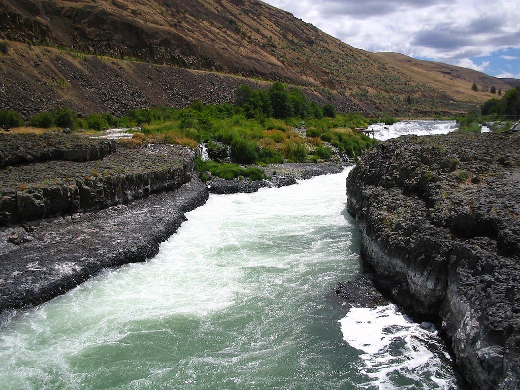
White River Falls sits at 1,007 feet within White River Falls State Park, fed by the White River, in the foothills of Oregon. The falls drop 90 feet.
Height: 90 feet
Trail & Hike Details
The Approach
The moderate 0.8-mile out-and-back trail gains 200 feet of elevation on the way to the falls.
Trail Description
The trail to White River Falls is a short but moderately steep hike that takes visitors down to the base of the falls. The path is well-defined but can be rocky and uneven in places. Along the way, you'll pass remnants of the old hydroelectric power plant, adding a historical element to the hike.
What to Expect
The falls cascade 90 feet. Dogs are welcome.
Accessibility
The trail is not wheelchair accessible. Uneven terrain and elevation changes require steady footing.
Frequently Asked Questions
🐶 Are Dogs Allowed at White River Falls?
✅ Dogs are allowed
Are There Any Fees or Permits Required?
🆖 No fees required
🏊 Is There Swimming at White River Falls?
❌ Swimming is not allowed
When to Visit
Spring is the best time to visit, as the falls are at their fullest due to snowmelt. Summer and fall are also great times to visit, but the water flow may be lower.
Seasonal Access
The best time to visit is Spring, Summer, and Fall. Winter access may be limited.
Safety Information
Exercise caution near the water, as rocks can be slippery and the currents are strong. Stay on designated trails to avoid accidents.
Current Water Conditions
97 ft³/s
Current discharge — how much water is flowing
Much lower than usual for this time of year
Based on 78 years of record
1.47 ft
Water depth at gauge
7-Day Discharge Trend
What does this mean for your visit?
Flow is well below normal for this time of year, so the waterfall may be a trickle.
About This Gauge
7-Day Flow Outlook
Based on the USGS gauge WHITE RIVER BELOW TYGH VALLEY, OR (0 km away).
Today
Moderate
97 cfs
8/10Tomorrow
Moderate
99 cfs
5/10Sat
Moderate
101 cfs
5/10Sun
Moderate
91 cfs
8/10Mon
Moderate
85 cfs
8/10Tue
Moderate
82 cfs
8/10Wed
Moderate
80 cfs
8/10Best window: Today — moderate flow, mostly sunny (trip score 8/10).
Best time of year: this gauge typically runs highest from late March to early June, peaking in May.
How we calculate this
This is a transparent outlook, not a precise forecast. We take the waterfall's current flow strength (how it ranks against its historical normal for today, from the nearest USGS stream gauge), carry that ranking forward along the gauge's seasonal curve, and nudge it for forecast rain. Confidence is highest for the next day or two and falls further out. Always check official conditions and your own judgment before visiting — high flows can be dangerous.
Know when to go.
Get a free email alert when waterfalls near Tygh Valley hit peak flow. We only send when conditions are worth the trip — no weekly newsletters, no spam.
Weather Forecast
Location & Access
Getting There
White River Falls State Park is located about 35 miles south of The Dalles, Oregon, off Highway 197. The park is well-marked, and the falls are a short walk from the parking area.
Get Directions on Google MapsParking
There is a designated parking lot at White River Falls State Park, which is free to use. Parking is generally sufficient, but it may fill up during peak seasons.
Elevation
1,007 feet above sea level
Coordinates
45.242682° N, -121.097411° W
Land Management
Managed by CITY
Visitor Tips & Gear
Wear sturdy shoes, as the trail can be uneven and slippery, especially near the water. Bring water and sunscreen, as the area can get hot in the summer. Visit early in the day to avoid crowds and secure parking.
As an Amazon Associate, we earn from qualifying purchases.
With 0.8 miles and 200 ft of elevation gain, sturdy boots and trekking poles will help on this moderate trail. Sun exposure on the trail makes good sun protection a must in summer.

Polarized Sunglasses (Knockaround)
Cuts glare off the water so you actually see the falls — and your photos turn out better too.

Columbia Watertight II Rain Jacket
Packs into its own pocket, seam-sealed, and keeps you dry from spray and surprise rain.

Earth Pak Waterproof Dry Bag
Keeps your phone and gear dry when waterfall mist soaks everything else.

Waterproof Phone Pouch (AiRunTech)
Cheap insurance — take photos right next to the falls without killing your phone.

Timberland Euro Sprint Mid Waterproof
Trusted waterproof boot with premium leather and grippy rubber sole — reliable on rocky, wet trails.

TrailBuddy Trekking Poles
Lightweight aluminum, cork grips, and flip-locks that actually hold — a best-seller for good reason.
Where to Stay

Balch Hotel

Steps to Pine Hollow Reservoir: Home w/ Fire Pit!

Cooper Spur Mountain Resort

8 Mile Farm Bed & Breakfast
Browse vacation cabins and private rentals nearby
Unique outdoor stays — tents, yurts, and treehouses
Rent a campervan or RV for your waterfall road trip
Some links are affiliate links. We may earn a commission at no extra cost to you.
Nearby Campground
Twin Springs Campground
6.4 miles away · 0 sites
Wedged between the Lower Deschutes River Back Country Byway and the Deschutes River, Twin Springs Campground offers six individual campsites, each with a picnic table and firering. Bring you own shade: only one campsite has any and what sun protection it does offer is minimal.Know Before You GoTwin Springs Campground is open year-round with limited river access, one vault toilet and garbage service. There are no group-use campsites.No drinking water or utility hookups are available. No reservatio
Book on Recreation.govNearby Hot Springs
Hot springs near Tygh Valley, Oregon
Kahneeta Hot Springs
Kahneeta Hot Springs flows at 126°F on Warm Springs Reservation tribal land at 1,450 feet elevation, sitting just 6 meters from...

Springs
These thermal springs emerge at 125°F on sovereign Warm Springs Reservation land in Jefferson County, creating a 72-degree temp...

Swim Warm Springs
Swim Warm Springs emerges at 79°F within Mount Hood National Forest at 4,063 feet elevation, flowing just 6.9 meters from White...
Klickitat Mineral Springs
Klickitat Mineral Springs produces 81-degree water at just 481 feet elevation on state conservation lands, flowing 27.9 degrees...

Mount Hood Fumaroles
Mount Hood Fumaroles vent at 194°F from the flanks of Oregon's highest peak, among the state's most extreme geothermal features...

Collins Hot Springs
Collins Hot Springs emerges at 122 degrees just 127 feet above sea level in the Columbia River Gorge, producing water 68.4 degr...
Looking for a soak after your hike? Explore more hot springs near Tygh Valley, Oregon on SoakingSprings.
Explore Oregon springsAdditional Information
Nearby Attractions
The Dalles, Deschutes River State Recreation Area, and Maupin for rafting and fishing.
Wildlife
The area is home to various bird species, including hawks and eagles, as well as small mammals like squirrels and rabbits.
Cities near White River Falls
Nearby Waterfalls
Other waterfalls named White River Falls
1 other waterfall shares this name across the U.S.
Writing about White River Falls? Embed this waterfall on your site for free.