
Photo Credits (5)
Difficulty
Moderate
Trail Length
2.4 miles
Trail Type
Out And Back
Elevation Gain
350 ft
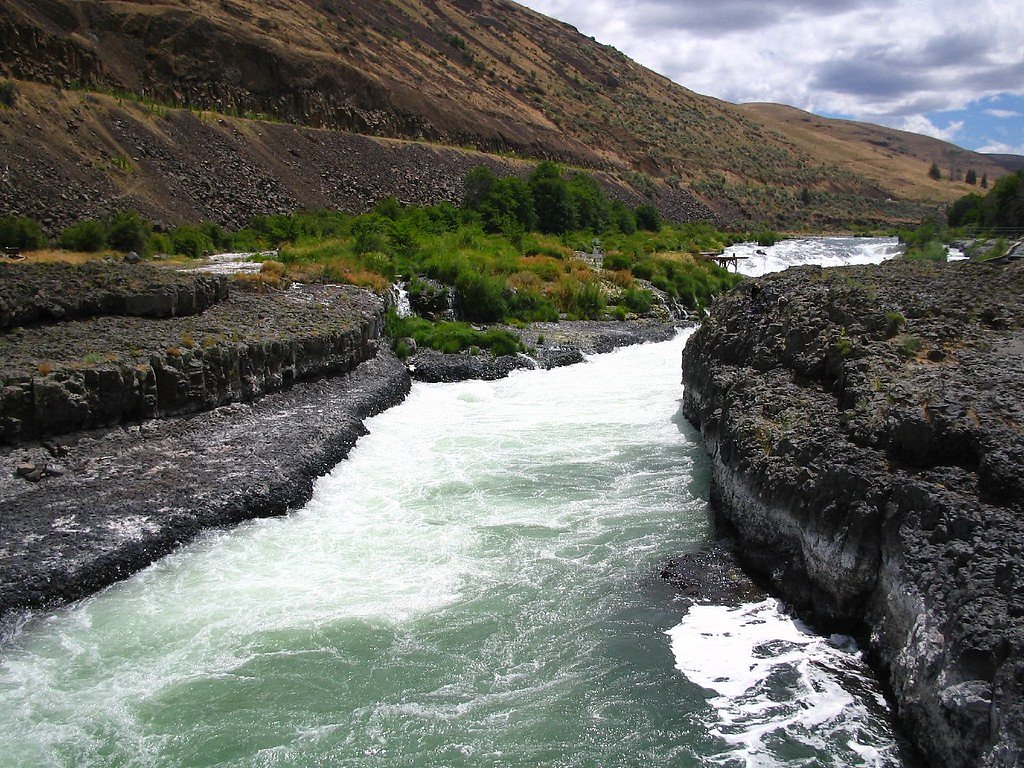
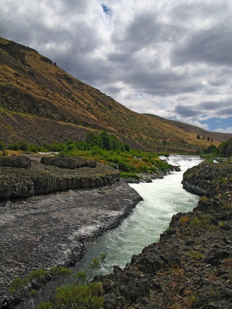
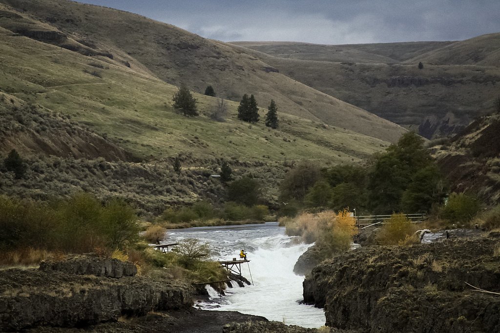
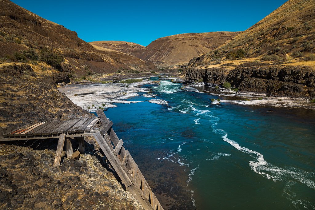
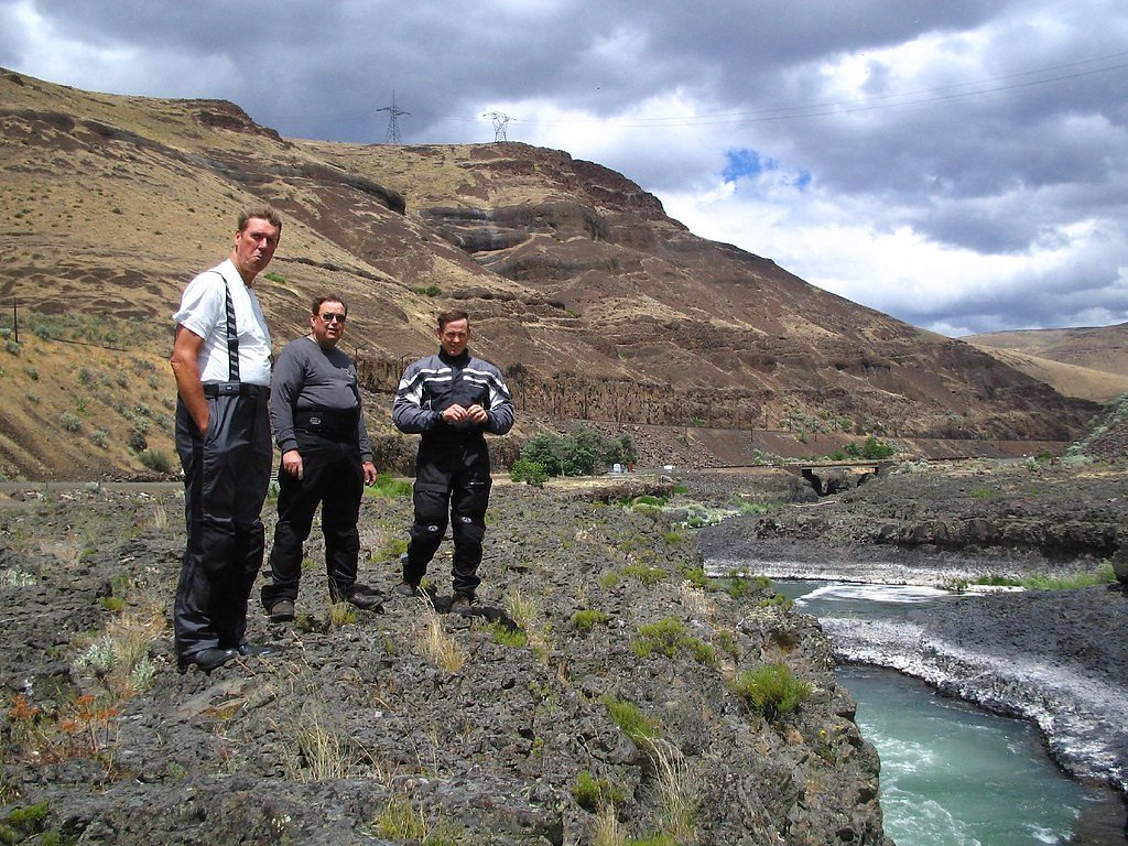
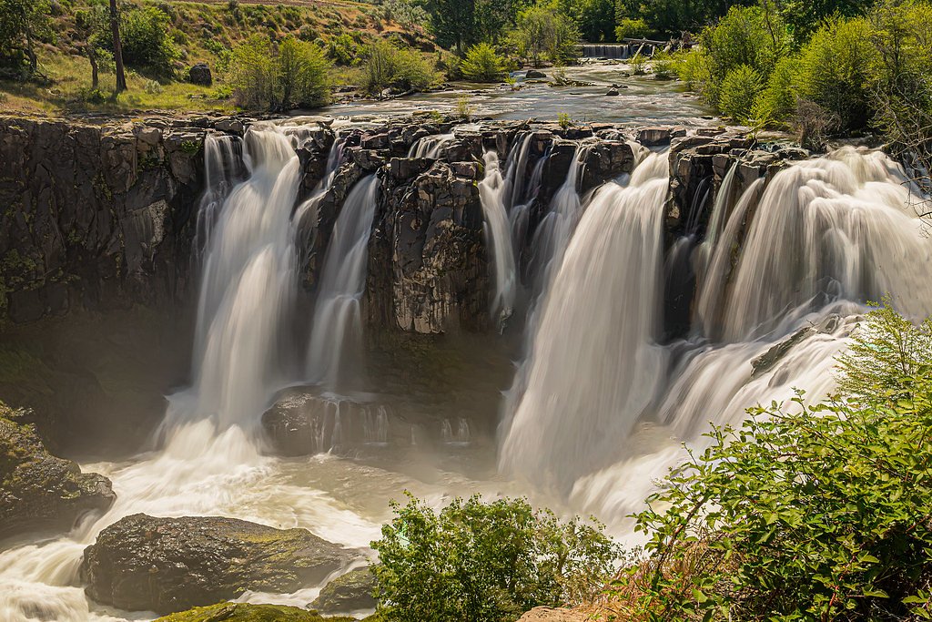
About Sherars Falls
Sherars Falls is a broad, powerful set of cascading rapids on the Deschutes River just north of Maupin, Oregon, at Sherar’s Bridge on Oregon Route 216. The falls drop roughly 15 feet and are the last waterfall on the Deschutes before it meets the Columbia River. Rather than a single vertical plunge, Sherars Falls is a violent, churning cascade — historically and recreationally significant, prized for salmon and steelhead fishing and long respected by local Native American tribes. Because the flow culminates in technical, dangerous water, the falls are rated class 6 whitewater and are under an administrative closure to boaters for public safety. The site sits on land listed as DESG and is managed by the Bureau of Land Management within the Deschutes River Segment E, a designated Wild and Scenic River. The falls are easily enjoyed from the roadside viewing areas at Sherar’s Bridge and nearby pullouts; for overnight stays Twin Springs Campground is about 5.62 km away. Visitors are encouraged to honor fishing traditions, obey closure signs, and treat the area with the respect due a place of both natural power and cultural importance.
The Setting
Sherars Falls sits at 686 feet within Deschutes River Segment E, fed by the Deschutes River, in the foothills of Oregon.
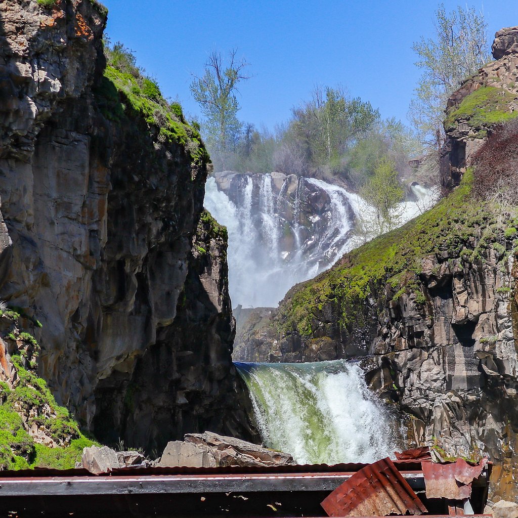
Nearby Falls Worth Visiting
White River Falls (90 ft) lies 3.4 miles to the west. Also nearby: Celestial Falls (45 ft, 3.4 mi).
Trail & Hike Details
The Approach
The moderate 2.4-mile out-and-back trail gains 350 feet of elevation on the way to the falls.
Trail Description
Primary viewing requires no hike: Sherars Falls is accessible directly from Oregon Route 216 with roadside parking and turnout areas at Sherar’s Bridge, making it an easy stop for photos and river watching. For those wanting a longer walk, the nearby route is described as a 2.4-mile out-and-back with about 350 feet of elevation gain and a moderate difficulty rating — a short hike that lets you take in more river viewpoints and surrounding scenery. No USFS trail number or specific surface/grade/class data is listed for the access; trail surfaces and conditions can vary, so wear sturdy shoes and be prepared for uneven ground near the river. Note: boating through the falls is administratively closed due to the extreme (class 6) whitewater hazard.
What to Expect
Visitors can expect to see a powerful series of rapids rather than a traditional waterfall. The area is often busy with fishermen, and the falls are a significant cultural site for Native American tribes. The sound of rushing water and the sight of fish ladders and fishing platforms add to the unique experience.
Accessibility
The trail is not wheelchair accessible. Uneven terrain and elevation changes require steady footing.
Frequently Asked Questions
🐶 Are Dogs Allowed at Sherars Falls?
❌ Dogs are not allowed
Are There Any Fees or Permits Required?
🆖 No fees required
🏊 Is There Swimming at Sherars Falls?
❌ Swimming is not allowed
When to Visit
Spring and fall are ideal for observing fishing activities, while summer offers warmer weather for general sightseeing.
Seasonal Access
The best time to visit is Spring, Summer, Fall, and Winter.
Safety Information
Exercise caution near the water, as the currents are strong and the rocks can be slippery. Be mindful of fishing equipment and platforms.
Current Water Conditions
63°F
CoolRefreshing for swimming
What does this mean for your visit?
Water temperature is a refreshing 63 degrees F, good for a quick swim.
About This Gauge
7-Day Flow Outlook
Based on the USGS gauge DESCHUTES RIVER AT SHERARS BRIDGE, OR (0 km away).
Best time of year: this gauge typically runs highest from mid February to mid April, peaking in April.
How we calculate this
This is a transparent outlook, not a precise forecast. We take the waterfall's current flow strength (how it ranks against its historical normal for today, from the nearest USGS stream gauge), carry that ranking forward along the gauge's seasonal curve, and nudge it for forecast rain. Confidence is highest for the next day or two and falls further out. Always check official conditions and your own judgment before visiting — high flows can be dangerous.
Know when to go.
Get a free email alert when waterfalls near Maupin hit peak flow. We only send when conditions are worth the trip — no weekly newsletters, no spam.
Weather Forecast
Location & Access
Getting There
Sherars Falls is located near Maupin, Oregon, along Highway 216. It is easily accessible by car, with the falls visible from the road and nearby parking areas.
Get Directions on Google MapsParking
There is a small parking area near the falls, but availability may be limited during peak fishing seasons.
Elevation
686 feet above sea level
Coordinates
45.262264° N, -121.032551° W
Land Management
Managed by BLM
Visitor Tips & Gear
Visit during the salmon or steelhead runs to observe fishing activities. Be respectful of the cultural significance of the site and avoid interfering with fishing operations. Bring binoculars for a closer view of the falls and wildlife.
As an Amazon Associate, we earn from qualifying purchases.
With 2.4 miles and 350 ft of elevation gain, sturdy boots and trekking poles will help on this moderate trail. Icy conditions are common in winter — traction cleats are a smart addition.

Columbia Watertight II Rain Jacket
Packs into its own pocket, seam-sealed, and keeps you dry from spray and surprise rain.

Polarized Sunglasses (Knockaround)
Cuts glare off the water so you actually see the falls — and your photos turn out better too.

Earth Pak Waterproof Dry Bag
Keeps your phone and gear dry when waterfall mist soaks everything else.

Waterproof Phone Pouch (AiRunTech)
Cheap insurance — take photos right next to the falls without killing your phone.

Timberland Euro Sprint Mid Waterproof
Trusted waterproof boot with premium leather and grippy rubber sole — reliable on rocky, wet trails.

TrailBuddy Trekking Poles
Lightweight aluminum, cork grips, and flip-locks that actually hold — a best-seller for good reason.
Where to Stay

Balch Hotel

8 Mile Farm Bed & Breakfast

Steps to Pine Hollow Reservoir: Home w/ Fire Pit!

Cooper Spur Mountain Resort
Browse vacation cabins and private rentals nearby
Unique outdoor stays — tents, yurts, and treehouses
Rent a campervan or RV for your waterfall road trip
Some links are affiliate links. We may earn a commission at no extra cost to you.
Nearby Campground
Twin Springs Campground
3.5 miles away · 0 sites
Wedged between the Lower Deschutes River Back Country Byway and the Deschutes River, Twin Springs Campground offers six individual campsites, each with a picnic table and firering. Bring you own shade: only one campsite has any and what sun protection it does offer is minimal.Know Before You GoTwin Springs Campground is open year-round with limited river access, one vault toilet and garbage service. There are no group-use campsites.No drinking water or utility hookups are available. No reservatio
Book on Recreation.govNearby Hot Springs
Hot springs near Maupin, Oregon
Kahneeta Hot Springs
Kahneeta Hot Springs flows at 126°F on Warm Springs Reservation tribal land at 1,450 feet elevation, sitting just 6 meters from...

Springs
These thermal springs emerge at 125°F on sovereign Warm Springs Reservation land in Jefferson County, creating a 72-degree temp...

Swim Warm Springs
Swim Warm Springs emerges at 79°F within Mount Hood National Forest at 4,063 feet elevation, flowing just 6.9 meters from White...
Klickitat Mineral Springs
Klickitat Mineral Springs produces 81-degree water at just 481 feet elevation on state conservation lands, flowing 27.9 degrees...

Mount Hood Fumaroles
Mount Hood Fumaroles vent at 194°F from the flanks of Oregon's highest peak, among the state's most extreme geothermal features...

Collins Hot Springs
Collins Hot Springs emerges at 122 degrees just 127 feet above sea level in the Columbia River Gorge, producing water 68.4 degr...
Looking for a soak after your hike? Explore more hot springs near Maupin, Oregon on SoakingSprings.
Explore Oregon springsAdditional Information
Nearby Attractions
The town of Maupin offers rafting and fishing opportunities on the Deschutes River. White River Falls State Park is also nearby, featuring a more traditional waterfall.
Wildlife
The area is home to various fish species, including salmon and steelhead, as well as birds such as ospreys and eagles.
Cities near Sherars Falls
Nearby Waterfalls
Writing about Sherars Falls? Embed this waterfall on your site for free.