Treasure Falls
Colorado • 105 ft
By Armen Suny · Last verified Mar 2026
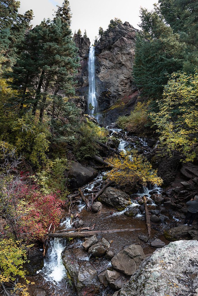
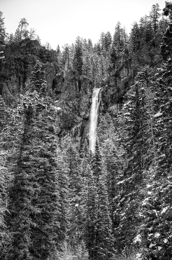
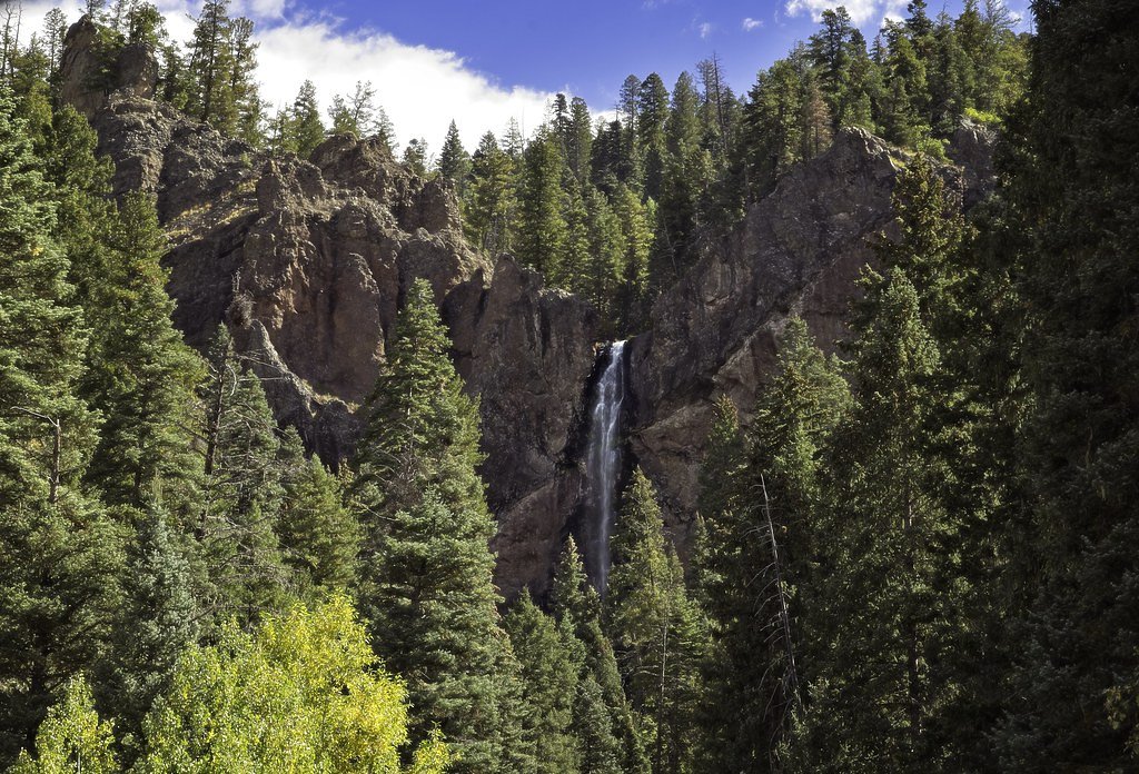
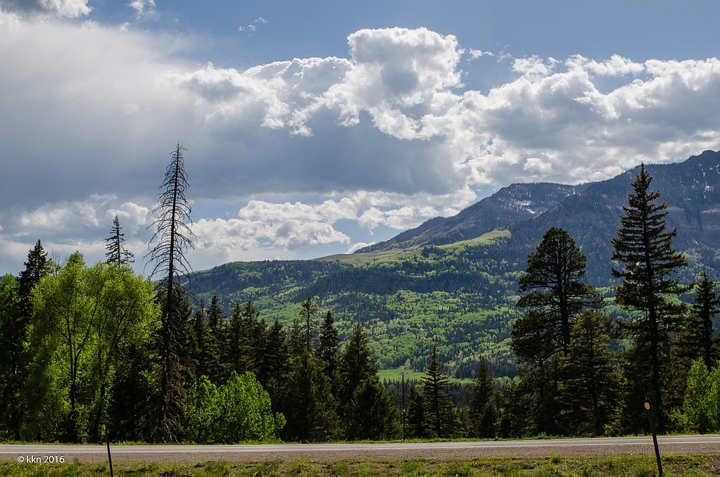
Photo Credits (5)
Difficulty
Easy
Trail Length
0.6 miles
Trail Type
Out And Back
Elevation Gain
200 ft
About Treasure Falls
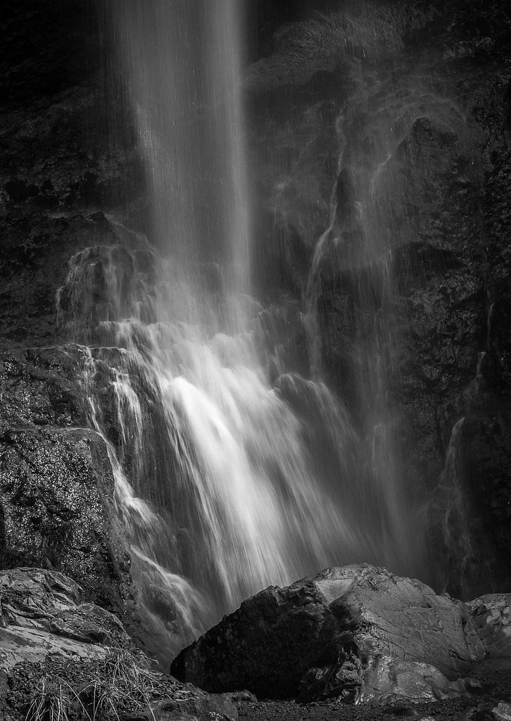
Treasure Falls is a striking 105-foot cascade tucked near Pagosa Springs, Colorado. Named for a local legend of buried treasure, the falls pour through a narrow canyon and offer a dramatic, easily photographed drop that rewards even very short visits. A wooden viewing platform perches near the base, giving close-up views and powerful misty scenes in spring runoff. Reaching the overlook is a quick and family-friendly outing: the out-and-back trail to the platform is just 0.6 miles round-trip with about 200 feet of elevation gain and is rated easy. The path is well-maintained with a handful of switchbacks and a moderate incline, making Treasure Falls an ideal stop for hikers looking for a high-impact sight with minimal effort.
The Setting
Treasure Falls sits at 9,006 feet along the Henson Creek, in the high alpine of Colorado. At 105 feet, it is among the taller waterfalls in Colorado.
Height: 105 feet
Trail & Hike Details
The Approach
The easy 0.6-mile out-and-back trail gains 200 feet of elevation on the way to the falls.
Trail Description
Trail length: 0.6 miles round-trip; elevation gain: approximately 200 feet; difficulty: easy. This short, out-and-back trail is well-maintained and climbs steadily via a few switchbacks before delivering you to a sturdy viewing platform near the base of the 105-foot waterfall. The route is compact and suitable for most visitors—families and casual hikers can expect a moderate uphill grade but nothing technical. The platform provides safe, close-up views of the falls and is the primary destination; the trail surface and facilities are kept in good condition for frequent day-use traffic.
What to Expect
The falls cascade 105 feet. Dogs are welcome.
Accessibility
The trail is not wheelchair accessible. Uneven terrain and elevation changes require steady footing.
Frequently Asked Questions
🐶 Are Dogs Allowed at Treasure Falls?
✅ Dogs are allowed
Are There Any Fees or Permits Required?
🆖 No fees required
🏊 Is There Swimming at Treasure Falls?
❌ Swimming is not allowed
When to Visit
Spring and early summer are ideal for viewing the waterfall at its fullest flow, but the area is beautiful year-round.
Seasonal Access
The best time to visit is Spring, Summer, Fall, and Winter.
Safety Information
The trail can be slippery when wet or icy, so exercise caution. Watch for falling rocks near the waterfall. Be prepared for changing weather conditions.
Current Water Conditions
78 ft³/s
Current discharge — how much water is flowing
About average for this time of year
Based on 7 years of record
7.21 ft
Water depth at gauge
7-Day Discharge Trend
What does this mean for your visit?
Flow is about average for this time of year.
About This Gauge
Know when to go.
Get a free email alert when waterfalls near Lake City hit peak flow. We only send when conditions are worth the trip — no weekly newsletters, no spam.
Weather Forecast
Location & Access
Getting There
Treasure Falls is located off U.S. Highway 160, approximately 15 miles northeast of Pagosa Springs, Colorado. There is a clearly marked parking area near the trailhead.
Get Directions on Google MapsParking
A small parking lot is available near the trailhead, but it can fill up quickly during peak times.
Elevation
9006 feet above sea level
Coordinates
38.019347° N, -107.362313° W
Visitor Tips & Gear
Arrive early to secure parking, especially during weekends and holidays. Wear sturdy shoes as the trail can be muddy or icy depending on the season. Bring water and a camera to capture the scenic views.
This trail sits at 9,006 ft — the air is noticeably thinner
High AltitudeSome visitors experience headaches, fatigue, or shortness of breath at this elevation. Take it slow, stay hydrated, and consider supplemental oxygen if you're coming from a lower altitude.
As an Amazon Associate, we earn from qualifying purchases.

Coppertone Sport SPF 50 Sunscreen
UV intensity jumps ~4% per 1,000 ft — at this elevation you can burn in half the time.

Sun Bum SPF 30 Lip Balm (3-Pack)
Lips have almost no natural UV protection and burn fast in thin, dry mountain air.

Liquid I.V. Electrolyte Packets
You lose moisture ~2x faster at elevation — electrolytes help you absorb water efficiently.

ROCKNIGHT Polarized UV400 Sunglasses
High-altitude glare off rock and water is intense — UV400 lenses block 99%+ of UVA/UVB.

Boost Oxygen 10L Canister (2-Pack)
Portable supplemental oxygen for quick relief from headaches and shortness of breath.

Altitude Rx OxyBoost Complex
Antioxidant formula designed to support your body's natural altitude acclimation.
As an Amazon Associate, we earn from qualifying purchases.
For this easy 0.6 miles trail, lightweight trail shoes and a water bottle are usually sufficient. Icy conditions are common in winter — traction cleats are a smart addition.

Columbia Watertight II Rain Jacket
Packs into its own pocket, seam-sealed, and keeps you dry from spray and surprise rain.

Polarized Sunglasses (Knockaround)
Cuts glare off the water so you actually see the falls — and your photos turn out better too.

Earth Pak Waterproof Dry Bag
Keeps your phone and gear dry when waterfall mist soaks everything else.

Waterproof Phone Pouch (AiRunTech)
Cheap insurance — take photos right next to the falls without killing your phone.

Kahtoola MICROspikes
Cult-favorite traction cleats that grip ice and wet rock — essential for winter waterfall hikes.

JOBY GorillaPod Starter Kit
Wraps around railings and rocks for long-exposure waterfall shots — no flat surface needed.
Where to Stay

Ouray Riverside Resort - Inn & Cabins

Hot Springs Inn

Vibrant Central Telluride Studio with Hot Tub and AC

Spacious Family Friendly Townhome on Telluride Mainstreet
Browse vacation cabins and private rentals nearby
Unique outdoor stays — tents, yurts, and treehouses
Rent a campervan or RV for your waterfall road trip
Some links are affiliate links. We may earn a commission at no extra cost to you.
Nearby Campground
Mill Creek Campground (CO)
7.9 miles away · 22 sites
Overview Mill Creek Campground is located 14 miles southwest of Lake City, Colorado at 9,500 feet above sea level. Nestled along the Lake Fork of the Gunnison River, the campground offers a fishing access trail for anglers and river access (though boating is not recommended from this location). The campground is surrounded by the Redcloud Peak and Handies Peak Wilderness Study Areas with world class hiking opportunities just a short drive away, including trails to three 14,000-foot peaks. From th
Book on Recreation.govNearby Hot Springs
Hot springs near Lake City, Colorado
Ouray Hot Springs
Ouray Hot Springs surfaces at a scalding 156°F at 7,800 feet elevation, one of Colorado's hottest springs that demands careful ...
Ouray Hot Springs Pool
Ouray Hot Springs Pool sits at 7,860 feet elevation in downtown Ouray, positioned just 97 feet from Main Street for maximum con...
Orvis Hot Spring
Orvis Hot Spring emerges at 126°F with heavily mineralized water dominated by sulfate, requiring a short walk through Ouray Cou...
Chattanooga Hot Spring
Chattanooga Hot Spring emerges at just 49 degrees Fahrenheit at 10,720 feet elevation near Silverton in San Juan County. Locate...

Cebolla Hot Springs
Cebolla Hot Springs emerges at 106 degrees Fahrenheit near Lake City in Hinsdale County at 8,158 feet elevation. The exceptiona...
Birdsie Warm Spring
Birdsie Warm Spring reaches 86 degrees Fahrenheit at nearly 9,000 feet elevation near Creede in Mineral County. Located just 15...
Looking for a soak after your hike? Explore more hot springs near Lake City, Colorado on SoakingSprings.
Explore Colorado springsAdditional Information
Nearby Attractions
Pagosa Springs, Wolf Creek Pass, San Juan National Forest
Wildlife
The area is home to various wildlife, including birds, deer, and small mammals. Be cautious of bears in the region.
Cities near Treasure Falls
Nearby Waterfalls
Other waterfalls named Treasure Falls
1 other waterfall shares this name across the U.S.
Writing about Treasure Falls? Embed this waterfall on your site for free.