Difficulty
Moderate
Trail Length
3.0 miles
Trail Type
Out And Back
Elevation Gain
500 ft
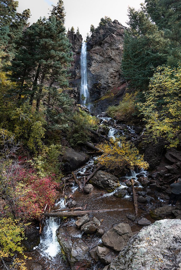
About Crooke Falls
Crooke Falls is a lesser-known Colorado cascade tucked into a quiet, forested setting that feels a world away from more crowded trailheads. The falls themselves offer a peaceful reward — a modest drop framed by evergreens and rocky ledges, ideal for hikers seeking a scenic, contemplative stop rather than a strenuous outing. The overall vibe is intimate and wooded, perfect for photographers and day-hikers who favor solitude. Access to the falls comes via a modest hike: the route is an out-and-back of about 3.0 miles round trip with roughly 500 feet of elevation gain and is typically rated moderate. Expect a natural singletrack that winds through mixed forest with some rocky, uneven sections; sturdy footwear and steady footing make the approach more enjoyable. The nearest developed campsite is Mill Creek Campground, about 13.85 km away, so plan accordingly for water and overnight options.
The Setting
Crooke Falls sits at 8,724 feet along the Henson Creek, in the high alpine of Colorado.
Trail & Hike Details
The Approach
The moderate 3.0-mile out-and-back trail gains 500 feet of elevation on the way to the falls.
Trail Description
Trail length: 3.0 miles (out-and-back). Elevation gain: approximately 500 feet. Difficulty: moderate. The path follows natural singletrack through forested terrain with mixed surface conditions—mainly dirt tread interspersed with rocky and uneven sections. Grade is generally moderate with occasional short, steeper pitches; the trail is suitable for hikers comfortable on rocky, uneven trails. Footwear with good traction is recommended. The route leads directly to the falls and a small viewing area where the cascade and pool can be enjoyed before returning the same way.
What to Expect
Visitors can expect a moderately challenging hike through a forested area, leading to a beautiful waterfall. The area around the falls is typically quiet and offers opportunities for photography and relaxation.
Accessibility
The trail is not wheelchair accessible. Uneven terrain and elevation changes require steady footing.
Frequently Asked Questions
🐶 Are Dogs Allowed at Crooke Falls?
❌ Dogs are not allowed
Are There Any Fees or Permits Required?
🆖 No fees required
🏊 Is There Swimming at Crooke Falls?
❌ Swimming is not allowed
When to Visit
The best time to visit Crooke Falls is during the spring and early summer when water flow is at its peak due to snowmelt. Fall also offers beautiful foliage, making it a great time for a visit.
Seasonal Access
The best time to visit is Spring, Summer, and Fall. Access roads and trails may close during winter due to snow.
Safety Information
Visitors should exercise caution on the trail, especially near the waterfall, as rocks may be slippery. Be prepared for sudden weather changes and carry a first aid kit.
Current Water Conditions
47 ft³/s
Current discharge — how much water is flowing
About average for this time of year
Based on 7 years of record
6.99 ft
Water depth at gauge
7-Day Discharge Trend
What does this mean for your visit?
Flow is about average for this time of year.
About This Gauge
7-Day Flow Outlook
Based on the USGS gauge HENSON CREEK AT LAKE CITY, CO (1 km away).
Today
Low
54 cfs
3/10Tomorrow
Low
49 cfs
6/10Sun
Low
45 cfs
6/10Mon
Low
43 cfs
6/10Tue
Low
40 cfs
6/10Wed
Low
38 cfs
6/10Thu
Low
36 cfs
6/10Best window: Tomorrow — low flow, sunny (trip score 6/10).
Best time of year: this gauge typically runs highest from late April to mid July, peaking in June.
How we calculate this
This is a transparent outlook, not a precise forecast. We take the waterfall's current flow strength (how it ranks against its historical normal for today, from the nearest USGS stream gauge), carry that ranking forward along the gauge's seasonal curve, and nudge it for forecast rain. Confidence is highest for the next day or two and falls further out. Always check official conditions and your own judgment before visiting — high flows can be dangerous.
Know when to go.
Get a free email alert when waterfalls near Lake City hit peak flow. We only send when conditions are worth the trip — no weekly newsletters, no spam.
Weather Forecast
Location & Access
Getting There
Crooke Falls is located within a forested area in Colorado. Access typically involves driving to a nearby trailhead and hiking to the falls. Specific directions may vary depending on the trailhead used.
Get Directions on Google MapsParking
Parking is available at the trailhead, but spaces may be limited during peak seasons. Visitors are advised to arrive early to secure a spot.
Elevation
8,724 feet above sea level
Coordinates
38.014164° N, -107.311722° W
Visitor Tips & Gear
Start your hike early to avoid crowds and secure parking. Bring plenty of water, snacks, and appropriate footwear. Be prepared for changing weather conditions, as Colorado's weather can be unpredictable.
This trail sits at 8,724 ft — the air is noticeably thinner
High AltitudeSome visitors experience headaches, fatigue, or shortness of breath at this elevation. Take it slow, stay hydrated, and consider supplemental oxygen if you're coming from a lower altitude.
As an Amazon Associate, we earn from qualifying purchases.

Coppertone Sport SPF 50 Sunscreen
UV intensity jumps ~4% per 1,000 ft — at this elevation you can burn in half the time.

Sun Bum SPF 30 Lip Balm (3-Pack)
Lips have almost no natural UV protection and burn fast in thin, dry mountain air.

Liquid I.V. Electrolyte Packets
You lose moisture ~2x faster at elevation — electrolytes help you absorb water efficiently.

ROCKNIGHT Polarized UV400 Sunglasses
High-altitude glare off rock and water is intense — UV400 lenses block 99%+ of UVA/UVB.

Boost Oxygen 10L Canister (2-Pack)
Portable supplemental oxygen for quick relief from headaches and shortness of breath.

Altitude Rx OxyBoost Complex
Antioxidant formula designed to support your body's natural altitude acclimation.
As an Amazon Associate, we earn from qualifying purchases.
With 3.0 miles and 500 ft of elevation gain, sturdy boots and trekking poles will help on this moderate trail. Sun exposure on the trail makes good sun protection a must in summer.

Columbia Watertight II Rain Jacket
Packs into its own pocket, seam-sealed, and keeps you dry from spray and surprise rain.

Earth Pak Waterproof Dry Bag
Keeps your phone and gear dry when waterfall mist soaks everything else.

Waterproof Phone Pouch (AiRunTech)
Cheap insurance — take photos right next to the falls without killing your phone.

Timberland Euro Sprint Mid Waterproof
Trusted waterproof boot with premium leather and grippy rubber sole — reliable on rocky, wet trails.

TrailBuddy Trekking Poles
Lightweight aluminum, cork grips, and flip-locks that actually hold — a best-seller for good reason.

Polarized Sunglasses (Knockaround)
Cuts glare off the water so you actually see the falls — and your photos turn out better too.
Where to Stay

Ouray Riverside Resort - Inn & Cabins

Vibrant Central Telluride Studio with Hot Tub and AC

Spacious Family Friendly Townhome on Telluride Mainstreet

Forbes 5 Star Luxury Hotel - 1 Br Ski-in Ski-out Residence in Mountain Village Colorado
Browse vacation cabins and private rentals nearby
Unique outdoor stays — tents, yurts, and treehouses
Rent a campervan or RV for your waterfall road trip
Some links are affiliate links. We may earn a commission at no extra cost to you.
Nearby Campground
Mill Creek Campground (CO)
8.6 miles away · 22 sites
Overview Mill Creek Campground is located 14 miles southwest of Lake City, Colorado at 9,500 feet above sea level. Nestled along the Lake Fork of the Gunnison River, the campground offers a fishing access trail for anglers and river access (though boating is not recommended from this location). The campground is surrounded by the Redcloud Peak and Handies Peak Wilderness Study Areas with world class hiking opportunities just a short drive away, including trails to three 14,000-foot peaks. From th
Book on Recreation.govNearby Hot Springs
Hot springs near Lake City, Colorado
Ouray Hot Springs
Ouray Hot Springs surfaces at a scalding 156°F at 7,800 feet elevation, one of Colorado's hottest springs that demands careful ...
Ouray Hot Springs Pool
Ouray Hot Springs Pool sits at 7,860 feet elevation in downtown Ouray, positioned just 97 feet from Main Street for maximum con...

Cebolla Hot Springs
Cebolla Hot Springs emerges at 106 degrees Fahrenheit near Lake City in Hinsdale County at 8,158 feet elevation. The exceptiona...
Orvis Hot Spring
Orvis Hot Spring emerges at 126°F with heavily mineralized water dominated by sulfate, requiring a short walk through Ouray Cou...
Chattanooga Hot Spring
Chattanooga Hot Spring emerges at just 49 degrees Fahrenheit at 10,720 feet elevation near Silverton in San Juan County. Locate...
Birdsie Warm Spring
Birdsie Warm Spring reaches 86 degrees Fahrenheit at nearly 9,000 feet elevation near Creede in Mineral County. Located just 15...
Looking for a soak after your hike? Explore more hot springs near Lake City, Colorado on SoakingSprings.
Explore Colorado springsAdditional Information
Nearby Attractions
Other hiking trails and natural attractions in the surrounding area may be worth exploring.
Wildlife
The area is home to various wildlife, including birds, deer, and small mammals. Be cautious and respectful of wildlife during your visit.
Cities near Crooke Falls
Nearby Waterfalls
Writing about Crooke Falls? Embed this waterfall on your site for free.