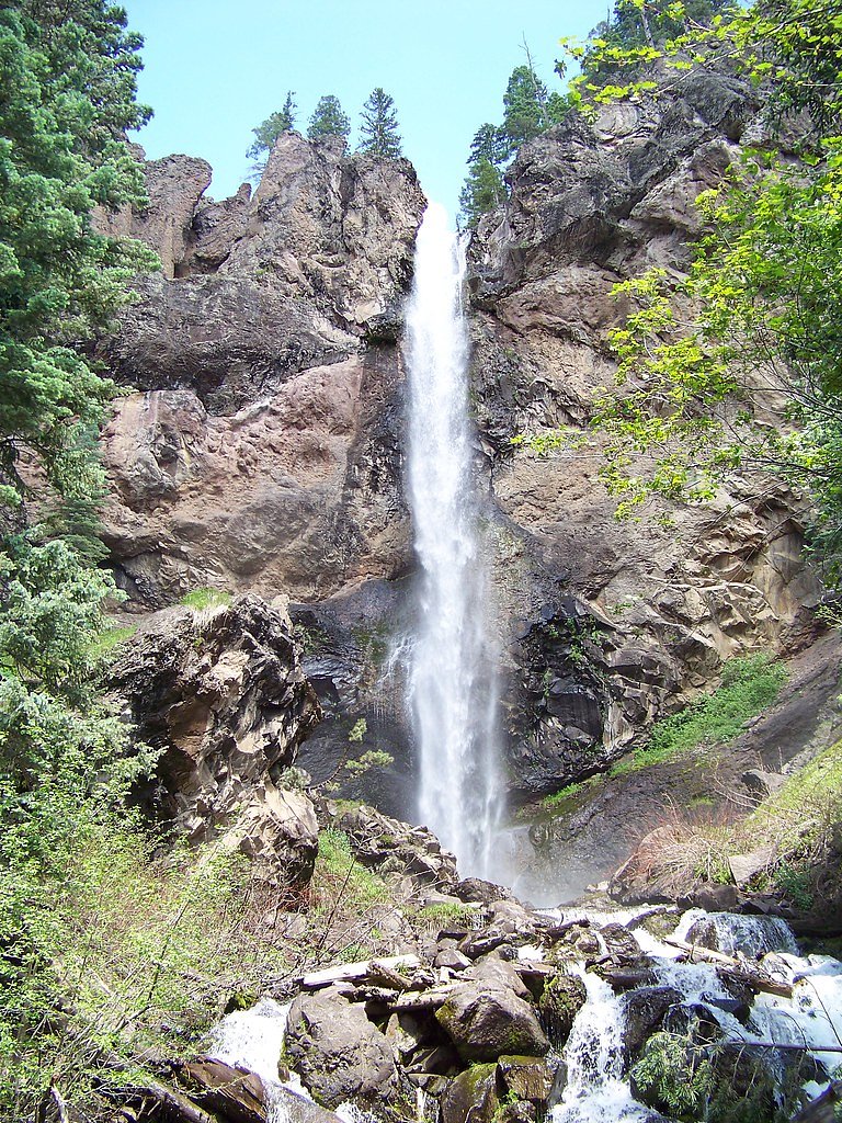
Treasure Falls
Colorado • 105 ft
By Armen Suny · Last verified Mar 2026
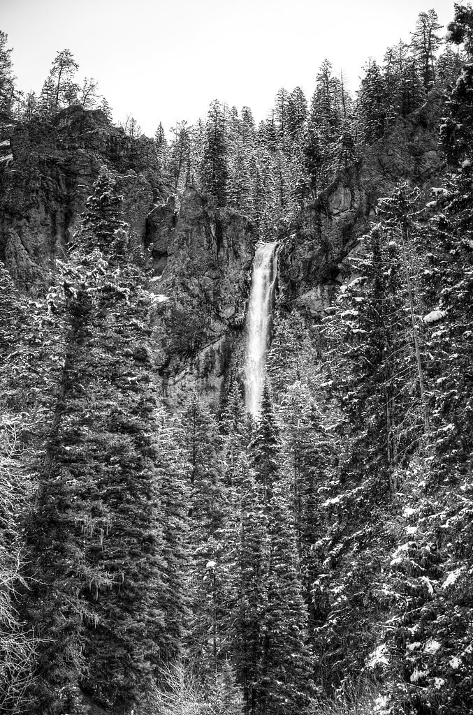
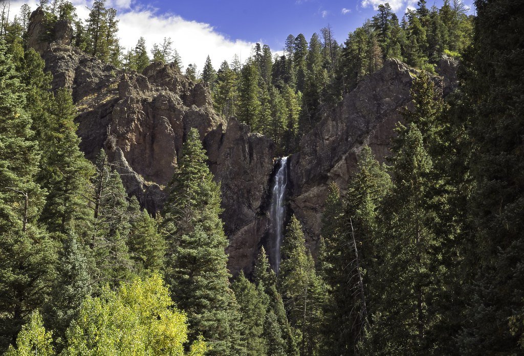
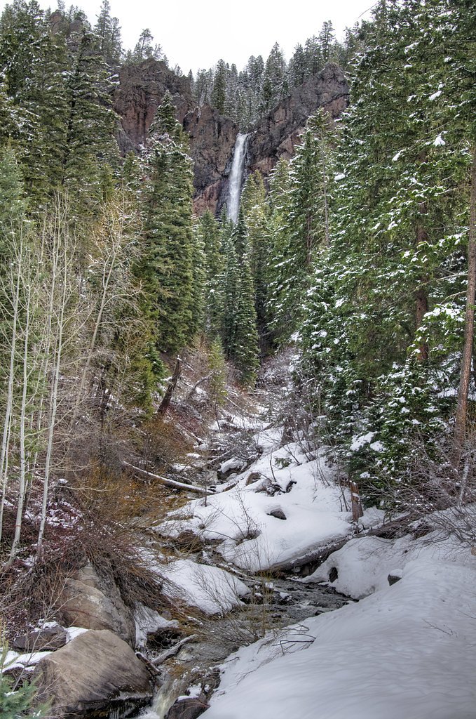
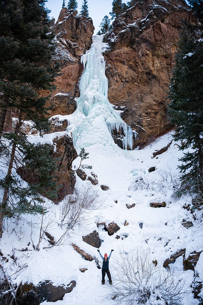

Photo Credits (5)
Difficulty
Easy
Trail Length
0.6 miles
Trail Type
Out And Back
Elevation Gain
200 ft
About Treasure Falls
Treasure Falls is a picturesque 105-foot waterfall located near Pagosa Springs, Colorado. It is named after a local legend about buried treasure in the area. The waterfall is easily accessible and offers stunning views year-round, with particularly dramatic flows during spring snowmelt.
The Setting
Treasure Falls sits at 8,543 feet within San Juan National Forest, fed by the San Juan River, in the high alpine of Colorado. At 105 feet, it is among the taller waterfalls in Colorado.
Height: 105 feet
Trail & Hike Details
The Approach
The easy hike follows Treasure Falls (#563), a 0.6-mile out-and-back trail over imported loose material. Expect 200 feet of elevation gain with grades of +12-20%. The trail is highly developed (Class 4).
USFS Trail
TREASURE FALLS #563
Trail Class
Highly Developed
Surface
Avg Grade
USFS Segment
0.38 miTrail Description
The trail to Treasure Falls is a short, well-maintained path that leads to a viewing platform near the base of the waterfall. The trail is relatively easy, with a few moderate inclines, and is suitable for most visitors. During winter, the trail may be icy or snow-covered, so proper footwear is recommended.
What to Expect
The falls cascade 105 feet. Dogs are welcome.
Accessibility
The trail is not wheelchair accessible. Uneven terrain and elevation changes require steady footing.
Frequently Asked Questions
🐶 Are Dogs Allowed at Treasure Falls?
✅ Dogs are allowed
Are There Any Fees or Permits Required?
🆖 No fees required
🏊 Is There Swimming at Treasure Falls?
❌ Swimming is not allowed
When to Visit
Spring and early summer are the best times to visit Treasure Falls for the most impressive water flow. Fall offers beautiful foliage, and winter provides a unique view of the partially frozen waterfall.
Seasonal Access
The best time to visit is Spring, Summer, Fall, and Winter. Check with San Juan National Forest for seasonal road closures.
Safety Information
The trail can be icy and slippery in winter. Visitors should wear appropriate footwear and exercise caution. Stay on the designated trail to avoid damaging the environment or risking injury.
Current Water Conditions
51 ft³/s
Current discharge — how much water is flowing
Much lower than usual for this time of year
Based on 90 years of record
4.13 ft
Water depth at gauge
7-Day Discharge Trend
What does this mean for your visit?
Flow is well below normal for this time of year, so the waterfall may be a trickle.
About This Gauge
This gauge is on a nearby waterway and may not reflect exact conditions at the falls.
7-Day Flow Outlook
Based on the USGS gauge SAN JUAN RIVER AT PAGOSA SPRINGS, CO (23 km away).
Today
Moderate
51 cfs
9/10Tomorrow
Moderate
45 cfs
9/10Mon
Moderate
40 cfs
9/10Tue
Moderate
37 cfs
9/10Wed
Moderate
41 cfs
9/10Thu
Moderate
38 cfs
9/10Fri
Moderate
33 cfs
9/10Best window: Today — moderate flow, sunny (trip score 9/10).
Best time of year: this gauge typically runs highest from early April to early July, peaking in June.
How we calculate this
This is a transparent outlook, not a precise forecast. We take the waterfall's current flow strength (how it ranks against its historical normal for today, from the nearest USGS stream gauge), carry that ranking forward along the gauge's seasonal curve, and nudge it for forecast rain. Confidence is highest for the next day or two and falls further out. Always check official conditions and your own judgment before visiting — high flows can be dangerous.
Know when to go.
Get a free email alert when waterfalls near Piedra hit peak flow. We only send when conditions are worth the trip — no weekly newsletters, no spam.
Weather Forecast
Location & Access
Getting There
Treasure Falls is located off U.S. Highway 160, approximately 15.2 miles northeast of Pagosa Springs. The trailhead is well-marked with a parking area directly off the highway.
Get Directions on Google MapsParking
There is a designated parking lot near the trailhead, which can accommodate several vehicles. Parking may fill up during peak times, especially in summer and fall.
Elevation
8,543 feet above sea level
Coordinates
37.443063° N, -106.873931° W
Land Management
Managed by USFS
Visitor Tips & Gear
Arrive early during peak seasons to secure parking. Wear sturdy shoes, especially in winter when the trail may be icy. Bring water and sunscreen, as the trail is exposed in some areas. Consider visiting in spring for the most dramatic water flow.
This trail sits at 8,543 ft — the air is noticeably thinner
High AltitudeSome visitors experience headaches, fatigue, or shortness of breath at this elevation. Take it slow, stay hydrated, and consider supplemental oxygen if you're coming from a lower altitude.
As an Amazon Associate, we earn from qualifying purchases.

Coppertone Sport SPF 50 Sunscreen
UV intensity jumps ~4% per 1,000 ft — at this elevation you can burn in half the time.

Sun Bum SPF 30 Lip Balm (3-Pack)
Lips have almost no natural UV protection and burn fast in thin, dry mountain air.

Liquid I.V. Electrolyte Packets
You lose moisture ~2x faster at elevation — electrolytes help you absorb water efficiently.

ROCKNIGHT Polarized UV400 Sunglasses
High-altitude glare off rock and water is intense — UV400 lenses block 99%+ of UVA/UVB.

Boost Oxygen 10L Canister (2-Pack)
Portable supplemental oxygen for quick relief from headaches and shortness of breath.

Altitude Rx OxyBoost Complex
Antioxidant formula designed to support your body's natural altitude acclimation.
As an Amazon Associate, we earn from qualifying purchases.
For this easy 0.6 miles trail, lightweight trail shoes and a water bottle are usually sufficient. Icy conditions are common in winter — traction cleats are a smart addition.

Columbia Watertight II Rain Jacket
Packs into its own pocket, seam-sealed, and keeps you dry from spray and surprise rain.

Polarized Sunglasses (Knockaround)
Cuts glare off the water so you actually see the falls — and your photos turn out better too.

Earth Pak Waterproof Dry Bag
Keeps your phone and gear dry when waterfall mist soaks everything else.

Waterproof Phone Pouch (AiRunTech)
Cheap insurance — take photos right next to the falls without killing your phone.

Kahtoola MICROspikes
Cult-favorite traction cleats that grip ice and wet rock — essential for winter waterfall hikes.

JOBY GorillaPod Starter Kit
Wraps around railings and rocks for long-exposure waterfall shots — no flat surface needed.
Where to Stay

Owl's Nest

Elktrace Bed and Breakfast

TALISMAN AMAZING VIEWS Walk to Uptown Sleeps 4

High Creek Lodge and Cabins
Browse vacation cabins and private rentals nearby
Unique outdoor stays — tents, yurts, and treehouses
Rent a campervan or RV for your waterfall road trip
Some links are affiliate links. We may earn a commission at no extra cost to you.
Nearby Campground
WEST FORK CAMPGROUND
1.6 miles away · 27 sites
Overview West Fork Campground sits near the West Fork San Juan River in a secluded 10-acre area, just over a mile from Highway 160. Visitors enjoy the area for its hiking opportunities and plentiful solitude.Recreation The West Fork and nearby Wolf Creek offer fishing opportunities, but are heavily fished streams. Only skilled and patient fishermen have much luck in these waters. The West Fork Trail, also known as the Rainbow Trail, leads into the Weminuche Wilderness from a trailhead a mile beyo
Book on Recreation.govNearby Hot Springs
Hot springs near Piedra, Colorado
Rainbow Hot Springs
Rainbow Hot Springs beckons adventurous soakers willing to undertake a substantial backcountry journey in the San Juan Mountain...

Pagosa Springs
Pagosa Springs (known as The Mother Spring) flows at 136°F in Archuleta County as the primary emergence point for the geotherma...
Pagosa Hot Springs
Pagosa Hot Springs holds local lore as the world's deepest known geothermal spring system, with thermal water emerging near roa...

Wagon Wheel Gap Hot Springs
Wagon Wheel Gap Hot Springs emerges at 135 degrees Fahrenheit in the upper Rio Grande River valley near the historic mining tow...
Hotz Spring
Hotz Spring emerges within the San Juan National Forest at 7,884 feet elevation in Archuleta County, where US Forest Service ma...

Antelope Spring
Antelope Spring emerges at a robust 90 degrees Fahrenheit at 8,950 feet elevation in Mineral County, Colorado, near the histori...
Looking for a soak after your hike? Explore more hot springs near Piedra, Colorado on SoakingSprings.
Explore Colorado springsAdditional Information
Nearby Attractions
Nearby attractions include Pagosa Springs, known for its hot springs, and the San Juan National Forest, which offers additional hiking and outdoor activities.
Wildlife
The area is home to various wildlife, including deer, birds, and small mammals. Visitors should be cautious of bears and avoid leaving food unattended.
Cities near Treasure Falls
Other waterfalls named Treasure Falls
1 other waterfall shares this name across the U.S.
Writing about Treasure Falls? Embed this waterfall on your site for free.