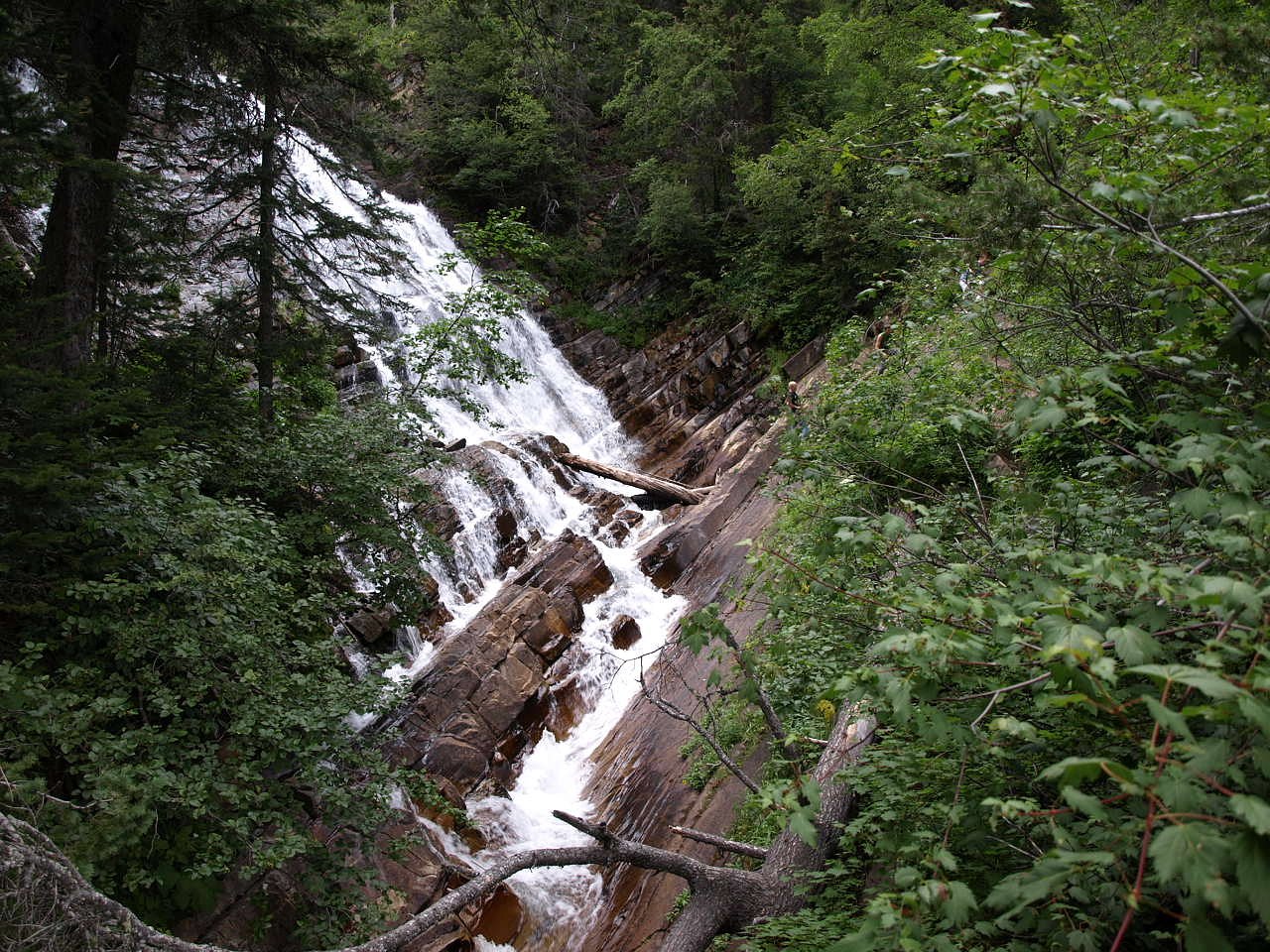
Thunderbird Falls
Montana • Glacier National Park
By Armen Suny · Last verified Mar 2026
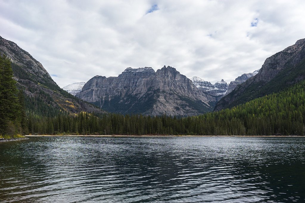
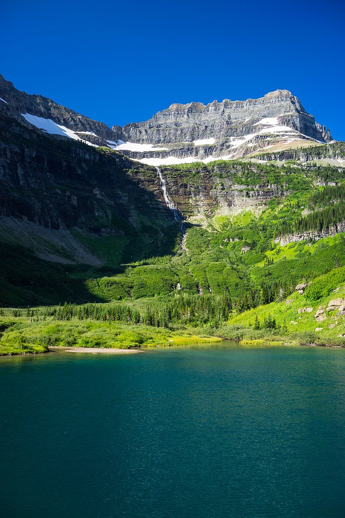


Photo Credits (5)
Difficulty
Easy
Trail Length
2.0 miles
Trail Type
Out And Back
Elevation Gain
200 ft
About Thunderbird Falls
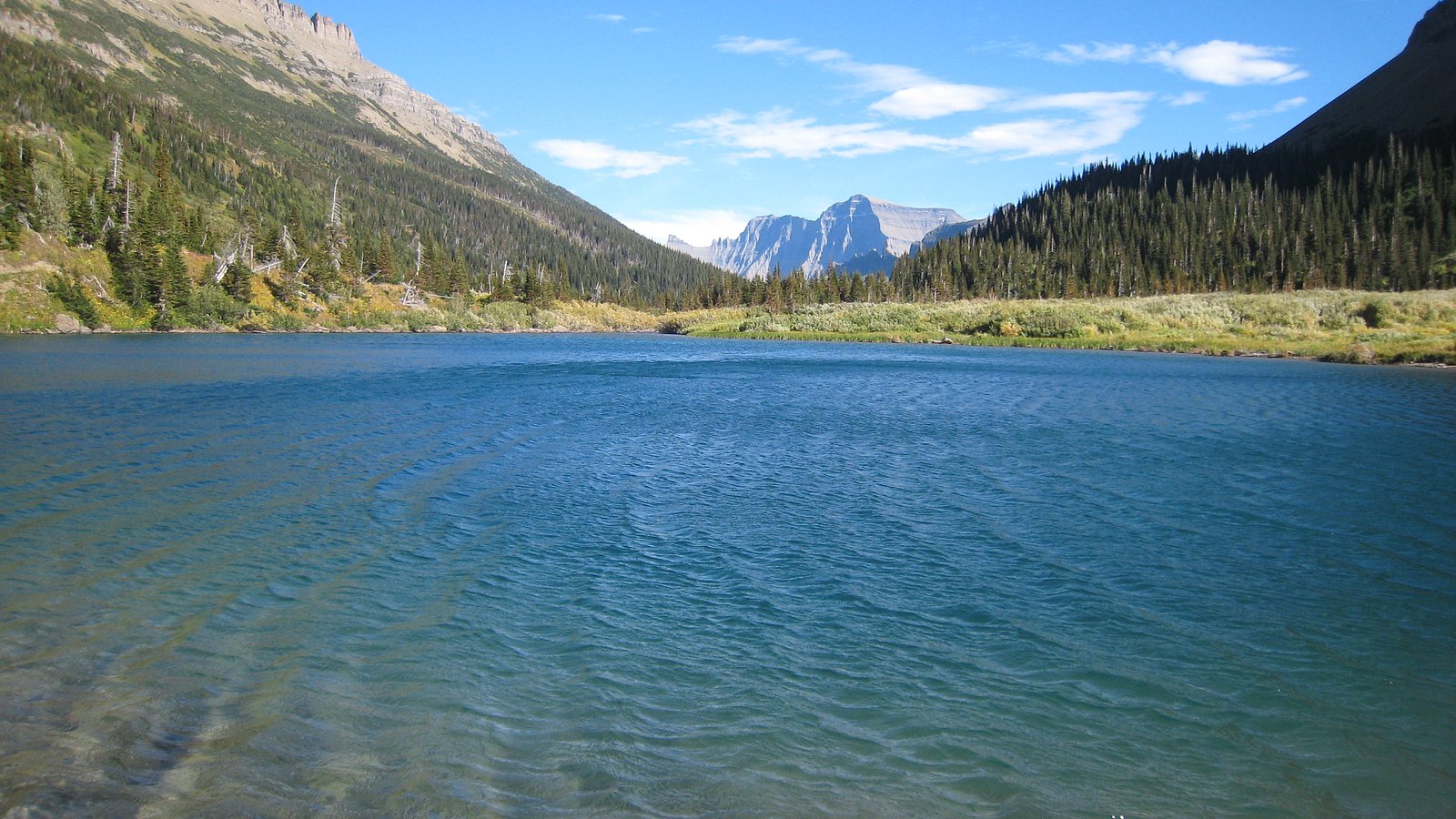
Thunderbird Falls is a scenic waterfall reached within Glacier National Park in Montana and managed by the National Park Service. A short, roughly 2.0-mile out-and-back trail with about 200 feet of elevation gain leads to the falls; the route is rated easy, making it a pleasant half-day outing for hikers and families exploring the park. The hike sits inside the national park’s boundaries, so visitors should plan according to NPS guidelines and seasonal conditions. While the trail’s modest climb rewards you with waterfall views without a strenuous ascent, the nearest designated camping noted in available park data is Schnau's Cabin, about 26 km away, so overnight plans may require travel to nearby backcountry or front-country sites outside the immediate trailhead area.
The Setting
Thunderbird Falls sits at 6,634 feet within Glacier National Park, fed by the Swiftcurrent Creek, in the high mountains of Montana.
Nearby Falls Worth Visiting
Lineham Falls (410 ft) lies 9.5 miles to the north. Also nearby: Upper Bertha Falls (246 ft, 7.6 mi).
Trail & Hike Details
The Approach
The easy 2.0-mile out-and-back trail gains 200 feet of elevation on the way to the falls.
Trail Description
Trail type: out-and-back. Total length: 2.0 miles (approximately 1.0 mile one-way). Elevation gain: ~200 feet. Difficulty: easy. Average grade is modest — roughly 200 ft of gain over the one-way distance (~4% average). Official surface type and technical trail class are not specified in the available NPS/park data; the route is described in park information as an accessible, short hike within Glacier National Park (managed by the National Park Service).
What to Expect
Dogs are welcome.
Accessibility
The trail is not wheelchair accessible. Uneven terrain and elevation changes require steady footing.
Frequently Asked Questions
🐶 Are Dogs Allowed at Thunderbird Falls?
✅ Dogs are allowed
Are There Any Fees or Permits Required?
🤑 Fee: $5.00
🏊 Is There Swimming at Thunderbird Falls?
❌ Swimming is not allowed
When to Visit
Spring and early summer are ideal for visiting, as the falls are typically at their fullest due to snowmelt. Fall offers beautiful foliage, while winter provides a chance to see the falls partially frozen.
Seasonal Access
The best time to visit is Spring, Summer, Fall, and Winter. Check with Glacier National Park for current conditions.
Safety Information
The trail can be slippery during wet or icy conditions. Visitors should exercise caution and stay on marked paths. Be aware of wildlife and carry bear spray if hiking during bear season.
Current Water Conditions
Based on a USGS gauge 19.7 miles away
260 ft³/s
Current discharge — how much water is flowing
Lower than usual for this time of year
Based on 114 years of record
2.37 ft
Water depth at gauge
7-Day Discharge Trend
What does this mean for your visit?
Flow is lower than usual for this time of year.
About This Gauge
This gauge is on a regional waterway. Conditions at the falls may differ, especially after local rain.
7-Day Flow Outlook
Based on the USGS gauge Swiftcurrent Creek at Many Glacier MT (32 km away).
Today
Moderate
296 cfs
6/10Tomorrow
Moderate
307 cfs
6/10Mon
Moderate
300 cfs
6/10Tue
Moderate
302 cfs
6/10Wed
Moderate
296 cfs
6/10Thu
Moderate
249 cfs
9/10Fri
Moderate
256 cfs
6/10Best window: Thu — moderate flow, mostly sunny (trip score 9/10).
Best time of year: this gauge typically runs highest from late April to late July, peaking in June.
How we calculate this
This is a transparent outlook, not a precise forecast. We take the waterfall's current flow strength (how it ranks against its historical normal for today, from the nearest USGS stream gauge), carry that ranking forward along the gauge's seasonal curve, and nudge it for forecast rain. Confidence is highest for the next day or two and falls further out. Always check official conditions and your own judgment before visiting — high flows can be dangerous.
Know when to go.
Get a free email alert when waterfalls near Polebridge hit peak flow. We only send when conditions are worth the trip — no weekly newsletters, no spam.
Weather Forecast
Location & Access
Getting There
Thunderbird Falls is located off the Glenn Highway, approximately 30 minutes north of Anchorage, Alaska. The trailhead is well-marked and accessible via a short drive from the highway.
Get Directions on Google MapsParking
There is a designated parking lot at the trailhead, which may require a small parking fee. Visitors should check for updated fee information before visiting.
Elevation
6,634 feet above sea level
Coordinates
48.940725° N, -114.032455° W
Land Management
Managed by NPS
Visitor Tips & Gear
Wear sturdy shoes, especially during wet or icy conditions. Bring insect repellent in the summer months, as mosquitoes can be present. Arrive early during peak seasons to secure parking.
This trail sits at 6,634 ft above sea level
Elevated TrailUV radiation is roughly 27% stronger at this elevation than at sea level, and the dry air accelerates dehydration. Extra sun protection and fluids go a long way.
As an Amazon Associate, we earn from qualifying purchases.

Coppertone Sport SPF 50 Sunscreen
UV intensity jumps ~4% per 1,000 ft — at this elevation you can burn in half the time.

Sun Bum SPF 30 Lip Balm (3-Pack)
Lips have almost no natural UV protection and burn fast in thin, dry mountain air.

Liquid I.V. Electrolyte Packets
You lose moisture ~2x faster at elevation — electrolytes help you absorb water efficiently.

ROCKNIGHT Polarized UV400 Sunglasses
High-altitude glare off rock and water is intense — UV400 lenses block 99%+ of UVA/UVB.
As an Amazon Associate, we earn from qualifying purchases.
This easy 2.0 miles hike is straightforward — comfortable trail shoes and plenty of water should do. Icy conditions are common in winter — traction cleats are a smart addition.
America the Beautiful Annual Pass
Covers entrance fees at 2,000+ federal recreation sites — required at most National Parks.

Columbia Watertight II Rain Jacket
Packs into its own pocket, seam-sealed, and keeps you dry from spray and surprise rain.

Polarized Sunglasses (Knockaround)
Cuts glare off the water so you actually see the falls — and your photos turn out better too.

Earth Pak Waterproof Dry Bag
Keeps your phone and gear dry when waterfall mist soaks everything else.

Waterproof Phone Pouch (AiRunTech)
Cheap insurance — take photos right next to the falls without killing your phone.

Kahtoola MICROspikes
Cult-favorite traction cleats that grip ice and wet rock — essential for winter waterfall hikes.

JOBY GorillaPod Starter Kit
Wraps around railings and rocks for long-exposure waterfall shots — no flat surface needed.
Where to Stay

Aspen Village

Waterton Lakes Lodge Resort

Prince of Wales Hotel

Waterton Glacier Suites
Browse vacation cabins and private rentals nearby
Unique outdoor stays — tents, yurts, and treehouses
Rent a campervan or RV for your waterfall road trip
Some links are affiliate links. We may earn a commission at no extra cost to you.
Nearby Campground
SCHNAUS CABIN
16.2 miles away · 1 sites
Overview Schnaus Cabin is located near the Wild and Scenic North Fork of the Flathead River, in the Flathead National Forest. It can host up to 12 guests for a scenic, peaceful mountain vacation. The rustic dwelling provides a superb setting for fishing, hiking, bird watching and much more in the Whitefish Mountains. The fully accessible cabin can be reached via vehicle and a parking area is located outside the cabin. Guests are responsible for their own travel arrangements and safety, and must b
Book on Recreation.govAdditional Information
Nearby Attractions
Eklutna Lake, Chugach State Park, and the town of Eagle River are nearby attractions worth exploring.
Wildlife
Visitors may encounter wildlife such as moose, birds, and small mammals along the trail. Always maintain a safe distance from animals.
Cities near Thunderbird Falls
Nearby Waterfalls
Writing about Thunderbird Falls? Embed this waterfall on your site for free.