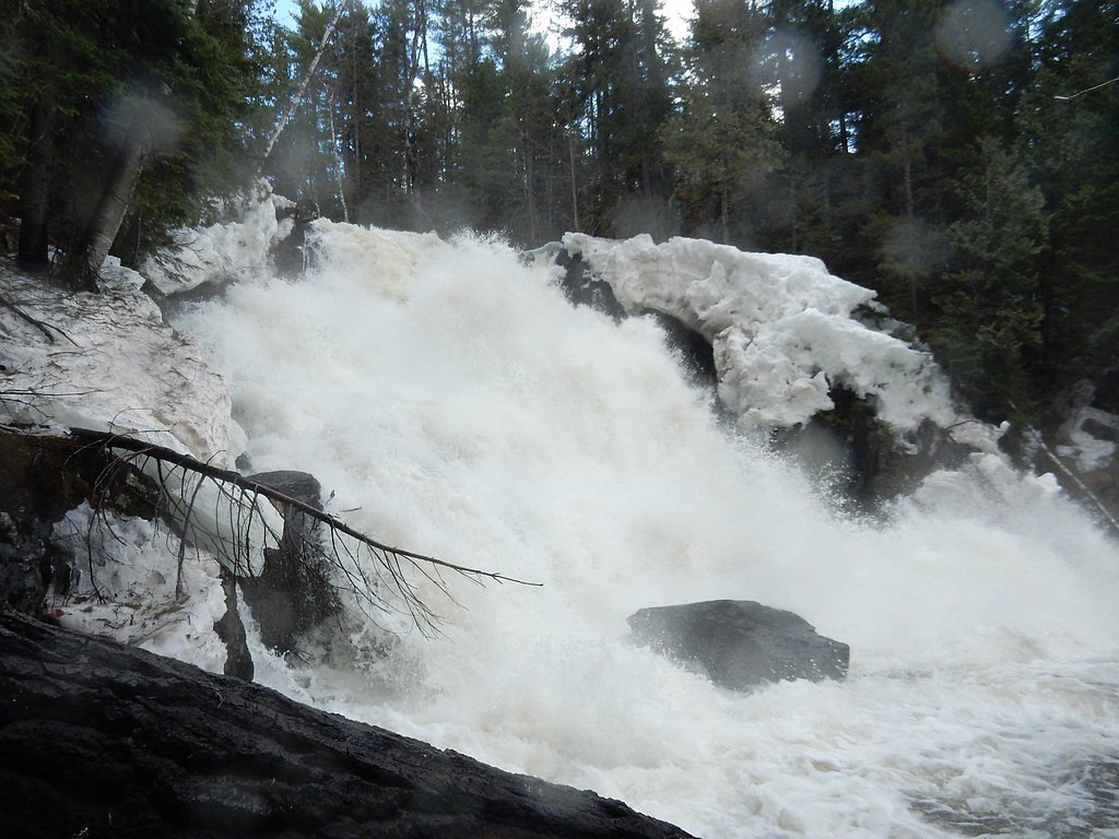
Sawtelle Falls
By Armen Suny · Last verified May 2026
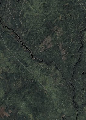
Photo Credits (2)
Difficulty
Moderate
Trail Length
2.4 miles
Trail Type
Out And Back
Elevation Gain
350 ft
About Sawtelle Falls
Sawtelle Falls is a secluded, scenic cascade set in a forested corner of Maine, ideal for hikers who enjoy a quiet nature escape. The falls are framed by mature woods and offer a photogenic plunge pool and shady spots to sit and listen to the rushing water. The walk to Sawtelle Falls is an out-and-back route of about 2.4 miles with roughly 350 feet of elevation gain and is generally rated moderate — brisk enough to get the heart pumping but accessible to most hikers in decent shape. Expect a mellow, restorative hike through mixed forest; sturdy footwear is recommended for the uneven, root-strewn sections that lead down to the water.
The Setting
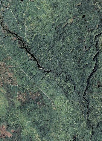
Sawtelle Falls sits at 600 feet along the Seboeis River, in the foothills of Maine.
Trail & Hike Details
The Approach
The moderate 2.4-mile out-and-back trail gains 350 feet of elevation on the way to the falls.
Trail Description
Out-and-back trail, approximately 2.4 miles with about 350 feet of elevation gain; rated moderate. The route follows a natural forest footpath that winds through wooded terrain and drops toward the falls. Surface is unimproved dirt with exposed roots and occasional uneven tread; sections can be steeper in places but there are no technical moves. Wear sturdy shoes, take care on the descent to the water, and be prepared for typical woods conditions (roots, leaf litter, and occasional slick rock near the stream).
What to Expect
Dogs are welcome.
Accessibility
The trail is not wheelchair accessible. Uneven terrain and elevation changes require steady footing.
Frequently Asked Questions
🐶 Are Dogs Allowed at Sawtelle Falls?
✅ Dogs are allowed
Are There Any Fees or Permits Required?
🆖 No fees required
🏊 Is There Swimming at Sawtelle Falls?
❌ Swimming is not allowed
When to Visit
Spring and early summer are the best times to visit, as the water flow is typically strongest during these seasons.
Seasonal Access
The best time to visit is Spring, Summer, and Fall. Winter access may be limited.
Safety Information
Be cautious of slippery rocks near the falls, especially after rain. Always supervise children and pets near the water. Cell service may be limited in the area, so plan accordingly.
Current Water Conditions
198 ft³/s
Current discharge — how much water is flowing
Higher than usual for this time of year
Based on 28 years of record
5.50 ft
Water depth at gauge
7-Day Discharge Trend
What does this mean for your visit?
The water is flowing higher than usual for this time of year.
About This Gauge
7-Day Flow Outlook
Based on the USGS gauge Seboeis River near Shin Pond, Maine (2 km away).
Today
Barely Flowing
214 cfs
3/10Tomorrow
Barely Flowing
238 cfs
4/10Tue
Barely Flowing
204 cfs
5/10Wed
Low
208 cfs
3/10Thu
Low
217 cfs
3/10Fri
Low
205 cfs
4/10Sat
Low
185 cfs
4/10Best window: Tue — barely flowing flow, mostly sunny (trip score 5/10).
Best time of year: this gauge typically runs highest from late March to late May, peaking in April.
How we calculate this
This is a transparent outlook, not a precise forecast. We take the waterfall's current flow strength (how it ranks against its historical normal for today, from the nearest USGS stream gauge), carry that ranking forward along the gauge's seasonal curve, and nudge it for forecast rain. Confidence is highest for the next day or two and falls further out. Always check official conditions and your own judgment before visiting — high flows can be dangerous.
Know when to go.
Get a free email alert when waterfalls near Patten hit peak flow. We only send when conditions are worth the trip — no weekly newsletters, no spam.
Weather Forecast
Location & Access
Getting There
Sawtelle Falls is located near the town of Jackman, Maine. Access typically involves driving on local roads, and the falls may be reached via a short walk from a nearby parking area.
Get Directions on Google MapsParking
Parking is available near the trailhead, but spaces may be limited depending on the season.
Elevation
600 feet above sea level
Coordinates
46.154213° N, -68.649763° W
Visitor Tips & Gear
Visit during the spring or early summer for the best water flow. Bring insect repellent during warmer months, as mosquitoes and other insects may be present. Be cautious of slippery rocks near the falls.
As an Amazon Associate, we earn from qualifying purchases.
With 2.4 miles and 350 ft of elevation gain, sturdy boots and trekking poles will help on this moderate trail. Sun exposure on the trail makes good sun protection a must in summer.

Polarized Sunglasses (Knockaround)
Cuts glare off the water so you actually see the falls — and your photos turn out better too.

Columbia Watertight II Rain Jacket
Packs into its own pocket, seam-sealed, and keeps you dry from spray and surprise rain.

Earth Pak Waterproof Dry Bag
Keeps your phone and gear dry when waterfall mist soaks everything else.

Waterproof Phone Pouch (AiRunTech)
Cheap insurance — take photos right next to the falls without killing your phone.

Timberland Euro Sprint Mid Waterproof
Trusted waterproof boot with premium leather and grippy rubber sole — reliable on rocky, wet trails.

TrailBuddy Trekking Poles
Lightweight aluminum, cork grips, and flip-locks that actually hold — a best-seller for good reason.
Where to Stay

All Season Fun and Cozy Home in Island Falls, ME

Mattawamkeag River Cottage

Sewall House Yoga Retreat

Black Bear Dens
Browse vacation cabins and private rentals nearby
Unique outdoor stays — tents, yurts, and treehouses
Rent a campervan or RV for your waterfall road trip
Some links are affiliate links. We may earn a commission at no extra cost to you.
Nearby Campground
Katahdin Woods and Waters National Monument Camping and Huts
7.5 miles away · 27 sites
Overview Katahdin Woods and Waters National Monument is located in Maine’s north woods. Katahdin Woods and Waters protects part of an extraordinary natural and cultural landscape: the mountains, woods, and waters where the East Branch of the Penobscot River and its tributaries, including the Wassataquoik Stream and the Seboeis River, run freely. Campsites, lean-tos and huts located throughout the monument provide opportunities to stay overnight while hiking, biking, paddling and enjoying other re
Book on Recreation.govAdditional Information
Nearby Attractions
Nearby attractions include Moose River and the town of Jackman, which offers additional outdoor activities such as hiking and fishing.
Wildlife
The area is home to a variety of wildlife, including birds, deer, and occasionally moose. Visitors should remain cautious and respectful of wildlife.
Cities near Sawtelle Falls
Nearby Waterfalls
Writing about Sawtelle Falls? Embed this waterfall on your site for free.