Photo Credits (5)
Difficulty
Moderate
Trail Length
2.4 miles
Trail Type
Out And Back
Elevation Gain
350 ft
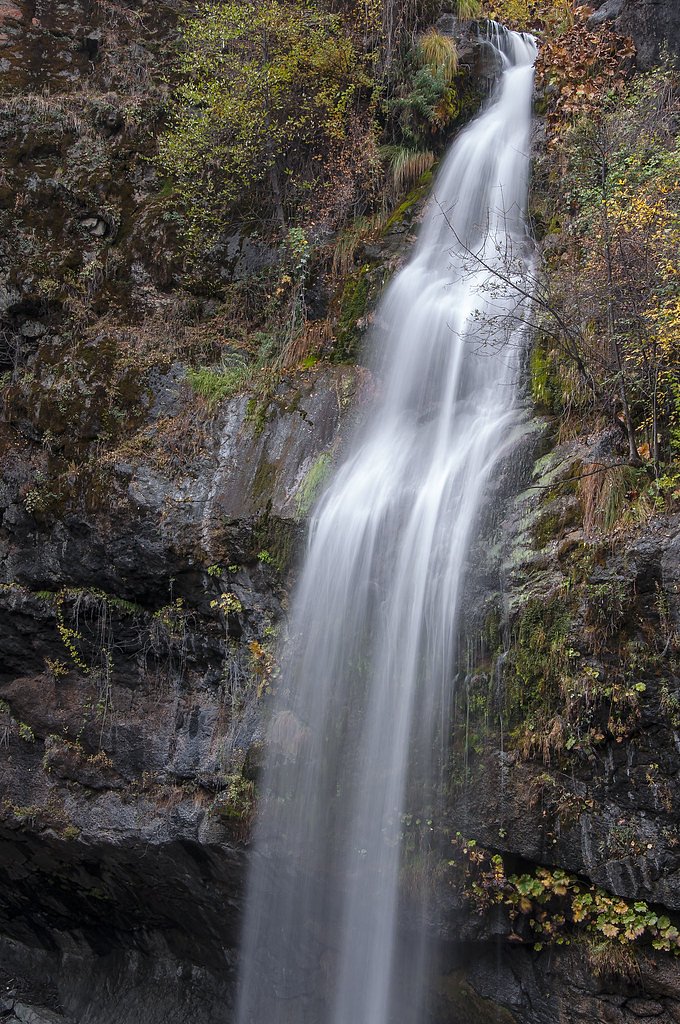
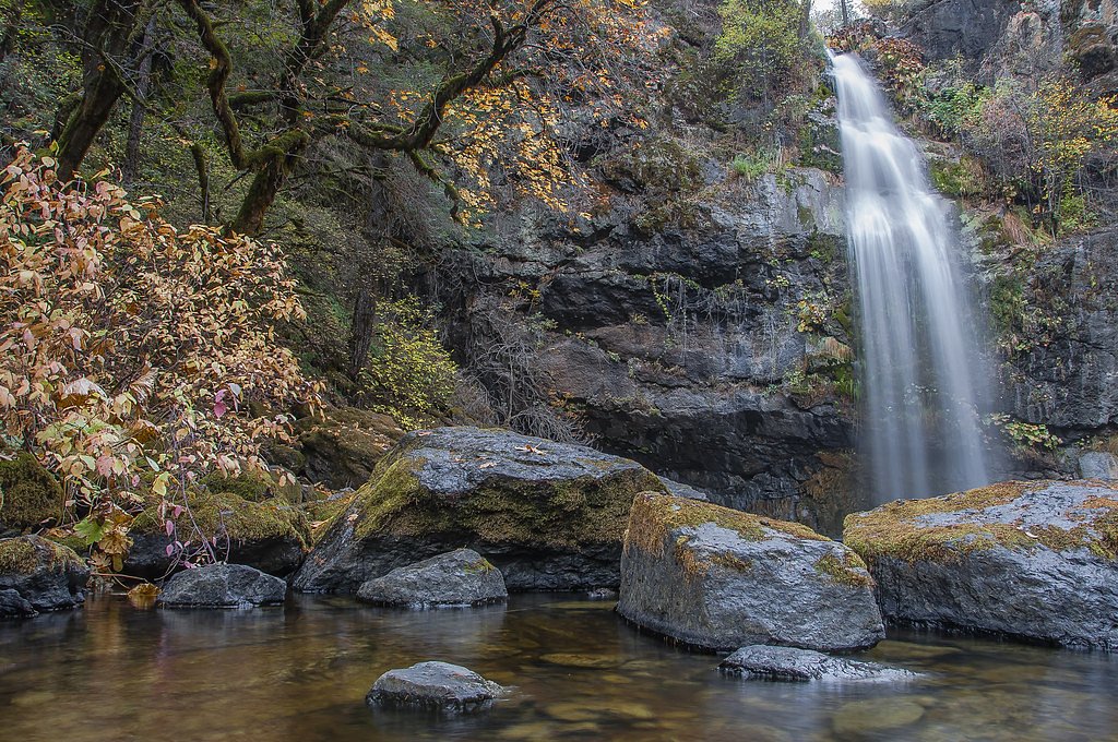
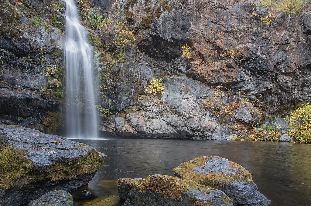
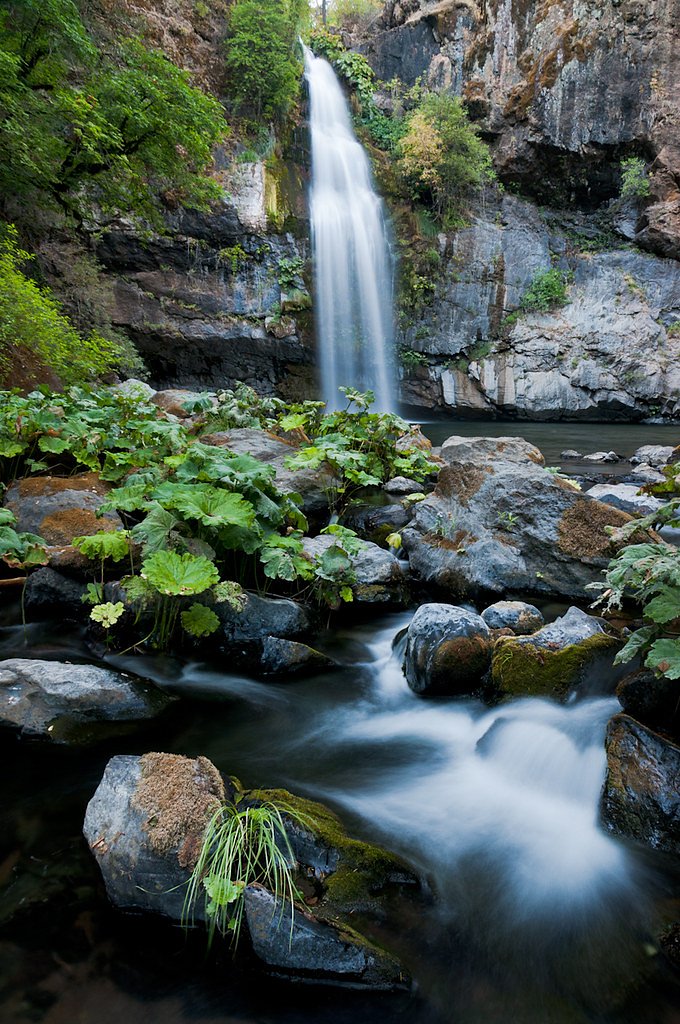
About Montgomery Creek Falls
Montgomery Creek Falls is a quietly scenic cascade tucked into the forested hills of Shasta County, California. The falls reward photographers and day-hikers with a peaceful setting where water tumbles into a rocky plunge pool framed by conifers and understory vegetation. The approach is intimate rather than grand — the setting feels like a tucked-away local gem rather than a heavily developed park.
Nearby Falls Worth Visiting
Potem Falls (70 ft) lies 5.2 miles to the west. Also nearby: Hatchet Creek Falls (30 ft, 2.7 mi).
Trail & Hike Details
The Approach
The moderate 2.4-mile out-and-back trail gains 350 feet of elevation on the way to the falls.
Trail Description
The route to Montgomery Creek Falls is a moderate 2.4-mile out-and-back with roughly 350 feet of elevation gain. The trail winds through forested terrain on a single, unpaved footpath and leads to a viewing spot near the base of the falls; the grade is generally steady but never technical, making it suitable for hikers comfortable with moderate climbs. There are no nearby developed campgrounds within 10 km—the nearest developed camping is at the Shasta Lake area about 21.2 km (≈13.2 miles) away.
What to Expect
Dogs are welcome.
Accessibility
The trail is not wheelchair accessible. Uneven terrain and elevation changes require steady footing.
Frequently Asked Questions
🐶 Are Dogs Allowed at Montgomery Creek Falls?
✅ Dogs are allowed
Are There Any Fees or Permits Required?
🆖 No fees required
🏊 Is There Swimming at Montgomery Creek Falls?
❌ Swimming is not allowed
When to Visit
Spring and early summer are the best times to visit, as the water flow is typically strongest during these seasons.
Seasonal Access
The best time to visit is Spring, Summer, and Fall. Winter access may be limited.
Safety Information
The rocks near the falls can be slippery, and the water flow may be strong. Visitors should exercise caution and avoid climbing on wet rocks. Be aware of potential wildlife encounters and stay on designated trails.
Know when to go.
Get a free email alert when waterfalls near Montgomery Creek hit peak flow. We only send when conditions are worth the trip — no weekly newsletters, no spam.
Weather Forecast
Location & Access
Getting There
Montgomery Creek Falls is located near the town of Montgomery Creek, California, along Highway 299. The falls are accessible via a short walk from a nearby parking area.
Get Directions on Google MapsParking
There is limited parking available near the trailhead along Highway 299. Visitors should plan to arrive early, especially during peak seasons, to secure a spot.
Elevation
2,041 feet above sea level
Coordinates
40.837934° N, -121.928330° W
Visitor Tips & Gear
Wear sturdy shoes with good grip, as the area near the falls can be wet and slippery. Arrive early to avoid crowds and secure parking. Bring a camera to capture the beauty of the falls.
As an Amazon Associate, we earn from qualifying purchases.
With 2.4 miles and 350 ft of elevation gain, sturdy boots and trekking poles will help on this moderate trail. Sun exposure on the trail makes good sun protection a must in summer.

Polarized Sunglasses (Knockaround)
Cuts glare off the water so you actually see the falls — and your photos turn out better too.

Columbia Watertight II Rain Jacket
Packs into its own pocket, seam-sealed, and keeps you dry from spray and surprise rain.

Earth Pak Waterproof Dry Bag
Keeps your phone and gear dry when waterfall mist soaks everything else.

Waterproof Phone Pouch (AiRunTech)
Cheap insurance — take photos right next to the falls without killing your phone.

Timberland Euro Sprint Mid Waterproof
Trusted waterproof boot with premium leather and grippy rubber sole — reliable on rocky, wet trails.

TrailBuddy Trekking Poles
Lightweight aluminum, cork grips, and flip-locks that actually hold — a best-seller for good reason.
Where to Stay

Green Gables Motel & Suites

Millz Manor

Burrowdale Inn

Shasta Pines Motel & Suites
Browse vacation cabins and private rentals nearby
Unique outdoor stays — tents, yurts, and treehouses
Rent a campervan or RV for your waterfall road trip
Some links are affiliate links. We may earn a commission at no extra cost to you.
Nearby Campground
Shasta Lake Area
13.2 miles away · 0 sites
** Due to fluctuating water levels on Shasta Lake, visitors are encouraged to contact the Shasta Recreation Company (concessionaire to the Forest Service) @ 530-275-8113 or the Shasta-Triinity National Forest, Shasta Lake Ranger Station at (530) 275-1587 for possible temporary campground closures. **The Shasta Unit is one of three units that comprise the Whiskeytown - Shasta-Trinity National Recreation Area. It was established by Congress in 1965. These areas were recognized for their unique and
Book on Recreation.govNearby Hot Springs
Hot springs near Montgomery Creek, California
Big Bend Hot Springs
Big Bend Hot Springs surges at a scalding 180 degrees Fahrenheit from volcanic terrain at just 1,644 feet elevation, creating o...
Big Bend, California
Big Bend sits along a dramatic curve of the Pit River in Shasta County at 1,720 feet elevation, occupying territory historicall...
Hunt Hot Spring
Hunt Hot Spring produces 136-degree water from the forested slopes near McCloud in Siskiyou County at just 1,712 feet elevation...

Mill Creek Springs
Mill Creek Springs flows at a spectacular 150°F within Lassen Volcanic National Park, making it one of California's hottest spr...

Sulphur Works, Tophet Hot Springs
Sulphur Works and Tophet Hot Springs emerge at a dramatic 199°F at 6,932 feet elevation within Lassen Volcanic National Park, o...
Hot Springs
Hot Springs emerge from the canyon walls of the Pit River in Shasta County at 3,310 feet elevation, their thermal nature docume...
Looking for a soak after your hike? Explore more hot springs near Montgomery Creek, California on SoakingSprings.
Explore California springsAdditional Information
Nearby Attractions
Burney Falls, Lassen Volcanic National Park, and McArthur-Burney Falls Memorial State Park are located within driving distance.
Wildlife
The area is home to various wildlife, including birds, deer, and small mammals. Visitors should be cautious of poison oak in the surrounding vegetation.
Cities near Montgomery Creek Falls
Nearby Waterfalls
Writing about Montgomery Creek Falls? Embed this waterfall on your site for free.