Difficulty
Moderate
Trail Length
4.0 miles
Trail Type
Out And Back
Elevation Gain
500 ft
About Mōhihi Falls
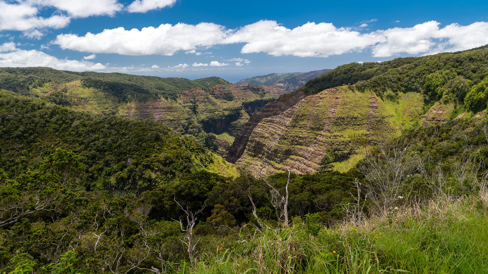
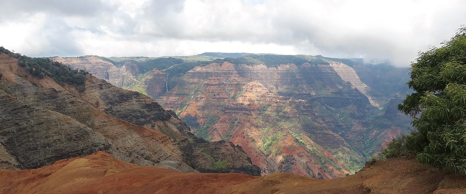
Mōhihi Falls is a tucked-away cascade on the island of Kauai that rewards hikers with a quiet, jungle-shrouded destination far from the busier tourist trails. Nestled within the Na Pali-kona Forest Reserve and managed by SDNR, the falls sit in a densely vegetated stretch of protected forest (designation: SCA), so visitors should expect a true backcountry feel and respect for the fragile surroundings. The hike to the falls is a moderate, out-and-back route of about 4.0 miles round trip with roughly 500 feet of elevation gain, making it a satisfying half-day excursion for fit day-hikers. Because Mōhihi Falls sees relatively few visitors, the setting is exceptionally serene — mossy rocks, thick understory, and the steady soundtrack of tropical birds and falling water. The remote nature of the site means trailfinding and leave-no-trace practices matter: bring sturdy footwear, ample water, and the expectation of narrow, sometimes indistinct tread through the forest. This is a great pick for hikers seeking solitude and a verdant Kauai waterfall experience under SDNR stewardship.
The Setting
Mōhihi Falls sits at 2,349 feet within Na Pali-kona Forest Reserve, fed by the Kawaikoi Stream, in the hills of Hawaii.
Trail & Hike Details
The Approach
The moderate 4.0-mile out-and-back trail gains 500 feet of elevation on the way to the falls.
Trail Description
Trail length: 4.0 miles (out-and-back). Elevation gain: ~500 feet. Difficulty: moderate. The route to Mōhihi Falls winds through dense tropical forest inside the Na Pali-kona Forest Reserve (managed by SDNR). Expect natural tread that can become muddy and slippery after rain, with sections that are narrow and not always well-marked — a map or GPS and basic route-finding skills are recommended. The final approach may require negotiating uneven terrain and crossing small streams, so waterproof boots or quick-drying footwear and caution near wet rock are wise. No formal trail surface or numbered agency trail designation is posted; plan for a true backcountry hike and allow extra time for slower footing and navigation.
What to Expect
Visitors can expect a peaceful and secluded waterfall surrounded by lush greenery. The area is rich in natural beauty, with the sound of cascading water and the possibility of spotting native birds and plants.
Accessibility
The trail is not wheelchair accessible. Uneven terrain and elevation changes require steady footing.
Frequently Asked Questions
🐶 Are Dogs Allowed at Mōhihi Falls?
❌ Dogs are not allowed
Are There Any Fees or Permits Required?
🆖 No fees required
🏊 Is There Swimming at Mōhihi Falls?
❌ Swimming is not allowed
When to Visit
The waterfall is typically accessible year-round, but the best time to visit is during the drier months (May to September) to avoid muddy trail conditions.
Seasonal Access
The best time to visit is Spring, Summer, Fall, and Winter. Heavy rains during wet season (November through March) bring higher flow but can make trails slippery.
Safety Information
The trail can be slippery and muddy, especially after rain. Stream crossings may be required, and flash flooding is a potential hazard during heavy rain. Visitors should check weather conditions and avoid hiking alone.
Current Water Conditions
7 ft³/s
Current discharge — how much water is flowing
About average for this time of year
Based on 111 years of record
2.12 ft
Water depth at gauge
7-Day Discharge Trend
What does this mean for your visit?
Flow is about average for this time of year.
About This Gauge
7-Day Flow Outlook
Based on the USGS gauge Kawaikoi Stream nr Waimea, Kauai, HI (2 km away).
Today
Barely Flowing
7 cfs
3/10Tomorrow
Low
8 cfs
4/10Tue
Low
7 cfs
4/10Wed
Low
8 cfs
4/10Thu
Low
8 cfs
4/10Fri
Low
10 cfs
4/10Sat
Low
8 cfs
4/10Best window: Tomorrow — low flow, scattered rain showers (trip score 4/10).
Best time of year: this gauge typically runs highest from late February to late April, peaking in March.
How we calculate this
This is a transparent outlook, not a precise forecast. We take the waterfall's current flow strength (how it ranks against its historical normal for today, from the nearest USGS stream gauge), carry that ranking forward along the gauge's seasonal curve, and nudge it for forecast rain. Confidence is highest for the next day or two and falls further out. Always check official conditions and your own judgment before visiting — high flows can be dangerous.
Know when to go.
Get a free email alert when waterfalls near Wainiha hit peak flow. We only send when conditions are worth the trip — no weekly newsletters, no spam.
Weather Forecast
Location & Access
Getting There
Mōhihi Falls is located in the Kōkeʻe State Park area on the island of Kauai. Access typically involves navigating unpaved roads and hiking through forested trails. A 4WD vehicle may be required to reach the trailhead, especially during wet conditions.
Get Directions on Google MapsParking
Parking is available near the trailhead, but spaces may be limited. Visitors should check local conditions and park regulations before arriving.
Elevation
2,349 feet above sea level
Coordinates
22.114889° N, -159.621650° W
Land Management
Managed by SDNR
Visitor Tips & Gear
Wear sturdy hiking shoes with good traction, as the trail can be muddy and slippery. Bring plenty of water, snacks, and insect repellent. Check weather conditions before heading out, as heavy rain can make the trail hazardous.
As an Amazon Associate, we earn from qualifying purchases.
With 4.0 miles and 500 ft of elevation gain, sturdy boots and trekking poles will help on this moderate trail. Icy conditions are common in winter — traction cleats are a smart addition.

Columbia Watertight II Rain Jacket
Packs into its own pocket, seam-sealed, and keeps you dry from spray and surprise rain.

Earth Pak Waterproof Dry Bag
Keeps your phone and gear dry when waterfall mist soaks everything else.

Waterproof Phone Pouch (AiRunTech)
Cheap insurance — take photos right next to the falls without killing your phone.

Timberland Euro Sprint Mid Waterproof
Trusted waterproof boot with premium leather and grippy rubber sole — reliable on rocky, wet trails.

TrailBuddy Trekking Poles
Lightweight aluminum, cork grips, and flip-locks that actually hold — a best-seller for good reason.

Kahtoola MICROspikes
Cult-favorite traction cleats that grip ice and wet rock — essential for winter waterfall hikes.
Where to Stay

Hanalei Bay Resort

Makai Club Resort

Kauai Shores Hotel

Poipu Plantation Vacation Rentals
Browse vacation cabins and private rentals nearby
Unique outdoor stays — tents, yurts, and treehouses
Rent a campervan or RV for your waterfall road trip
Some links are affiliate links. We may earn a commission at no extra cost to you.
Additional Information
Nearby Attractions
Kōkeʻe State Park, Waimea Canyon, and other waterfalls in the area such as Waipo'o Falls.
Wildlife
The area is home to native Hawaiian birds, such as the ʻapapane and ʻiʻiwi, as well as a variety of tropical plants.
Cities near Mōhihi Falls
Nearby Waterfalls

Writing about Mōhihi Falls? Embed this waterfall on your site for free.