Difficulty
Moderate
Trail Length
2.4 miles
Trail Type
Out And Back
Elevation Gain
350 ft
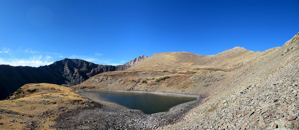
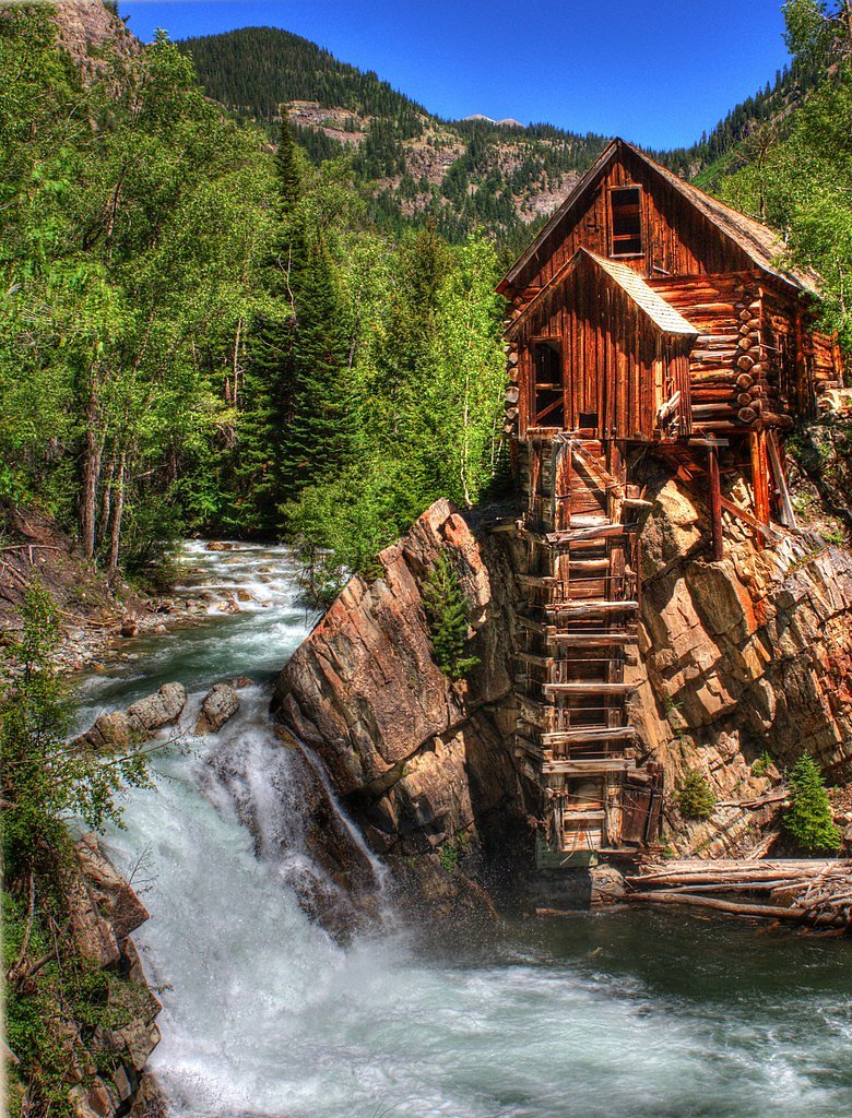
About Macey Falls
Macey Falls tumbles through a forested draw in the Sangre de Cristo Mountains and is tucked inside San Isabel National Forest, managed by the U.S. Forest Service. The falls are reached via the USFS MACEY SPUR (Trail #1341.A), a short native-surface spur to the cascade; many visitors combine that spur with the broader approach to make a rewarding 2.4-mile out-and-back hike with about 350 feet of elevation gain. The route’s moderate rating and handful of rocky, steeper sections make it a popular choice for day hikers looking for a relatively short outing with scenic payoff. Plan your visit for spring and early summer when snowmelt boosts the flow and the surrounding conifers and understory are especially lush. Camping is convenient enough for an overnight trip: Alvarado Campground lies about 8.29 km away, offering a nearby basecamp. Because the official spur (USFS GIS 0.32 miles) is native-material surface and class 3, bring sturdy footwear and basic route awareness—the setting is tranquil, but the approach rewards caution and curiosity alike.
The Setting
Macey Falls sits at 11,329 feet within San Isabel National Forest, in the high alpine of Colorado.
Trail & Hike Details
The Approach
The moderate hike follows Macey Spur (#1341.A), a 2.4-mile out-and-back trail over natural surface. Expect 350 feet of elevation gain. The trail is developed (Class 3).
USFS Trail
MACEY SPUR #1341.A
Trail Class
Developed
Surface
USFS Segment
0.32 miTrail Description
Trail type: out-and-back. Total logged distance: 2.4 miles round trip with ~350 feet elevation gain; difficulty: moderate. The U.S. Forest Service route to the falls is MACEY SPUR (Trail #1341.A) — the USFS GIS length for that spur is 0.32 miles. Surface: native material. Class: 3 (per USFS trail data). Expect short rocky and steeper sections on native soil; proper footwear and attention on steeper pitches are recommended. The waterfall’s flow is most impressive in spring and early summer during snowmelt.
What to Expect
Dogs are welcome.
Accessibility
The trail is not wheelchair accessible. Uneven terrain and elevation changes require steady footing.
Frequently Asked Questions
🐶 Are Dogs Allowed at Macey Falls?
✅ Dogs are allowed
Are There Any Fees or Permits Required?
🆖 No fees required
🏊 Is There Swimming at Macey Falls?
❌ Swimming is not allowed
When to Visit
The best time to visit Macey Falls is in late spring or early summer when the waterfall is at its fullest due to snowmelt. Fall is also a great time to visit for cooler weather and colorful foliage.
Seasonal Access
The best time to visit is Spring, Summer, and Fall. Access roads and trails may close during winter due to snow. Check with San Isabel National Forest for seasonal road closures.
Safety Information
Be prepared for sudden weather changes and carry sufficient water. Watch for loose rocks on the trail, and be cautious of wildlife. Cell phone service may be limited in the area.
Know when to go.
Get a free email alert when waterfalls near Crestone hit peak flow. We only send when conditions are worth the trip — no weekly newsletters, no spam.
Weather Forecast
Location & Access
Getting There
Macey Falls is located near Westcliffe, Colorado, in the San Isabel National Forest. The trailhead can be accessed via County Road 140, which leads to the Macey Lakes Trailhead. A high-clearance vehicle may be recommended for the last stretch of the road.
Get Directions on Google MapsParking
Parking is available at the Macey Lakes Trailhead, but spaces may be limited, especially during peak seasons.
Elevation
11,329 feet above sea level
Coordinates
38.004444° N, -105.567785° W
Land Management
Managed by USFS
Visitor Tips & Gear
Start your hike early to avoid crowds and ensure you have enough daylight for the return trip. Bring plenty of water, snacks, and layers, as weather conditions can change quickly in the mountains.
This trail sits at 11,329 ft — roughly 30% less oxygen than sea level
Extreme AltitudeAt this elevation, altitude sickness is a real concern. Monitor how you feel, take frequent rest breaks, and descend if symptoms worsen. Visitors arriving from lower elevations should allow time to acclimatize.
As an Amazon Associate, we earn from qualifying purchases.

Coppertone Sport SPF 50 Sunscreen
UV intensity jumps ~4% per 1,000 ft — at this elevation you can burn in half the time.

Sun Bum SPF 30 Lip Balm (3-Pack)
Lips have almost no natural UV protection and burn fast in thin, dry mountain air.

Liquid I.V. Electrolyte Packets
You lose moisture ~2x faster at elevation — electrolytes help you absorb water efficiently.

ROCKNIGHT Polarized UV400 Sunglasses
High-altitude glare off rock and water is intense — UV400 lenses block 99%+ of UVA/UVB.

Boost Oxygen 10L Canister (2-Pack)
Portable supplemental oxygen for quick relief from headaches and shortness of breath.

Altitude Rx OxyBoost Complex
Antioxidant formula designed to support your body's natural altitude acclimation.

Fingertip Pulse Oximeter
Monitor blood oxygen in real time — SpO2 commonly drops to 85–90% above 10,000 ft.
As an Amazon Associate, we earn from qualifying purchases.
With 2.4 miles and 350 ft of elevation gain, sturdy boots and trekking poles will help on this moderate trail. Sun exposure on the trail makes good sun protection a must in summer.

Columbia Watertight II Rain Jacket
Packs into its own pocket, seam-sealed, and keeps you dry from spray and surprise rain.

Earth Pak Waterproof Dry Bag
Keeps your phone and gear dry when waterfall mist soaks everything else.

Waterproof Phone Pouch (AiRunTech)
Cheap insurance — take photos right next to the falls without killing your phone.

Timberland Euro Sprint Mid Waterproof
Trusted waterproof boot with premium leather and grippy rubber sole — reliable on rocky, wet trails.

TrailBuddy Trekking Poles
Lightweight aluminum, cork grips, and flip-locks that actually hold — a best-seller for good reason.

Polarized Sunglasses (Knockaround)
Cuts glare off the water so you actually see the falls — and your photos turn out better too.
Where to Stay

Crestone Adobe Vista Manor

High Mountain Desert Earthship with Stunning Views

Hillside Colorado Cottages

Cozy Remote Retreat • Mountain Views • Stargazing
Browse vacation cabins and private rentals nearby
Unique outdoor stays — tents, yurts, and treehouses
Rent a campervan or RV for your waterfall road trip
Some links are affiliate links. We may earn a commission at no extra cost to you.
Nearby Campground
ALVARADO CAMPGROUND
5.2 miles away · 51 sites
Overview Alvarado Campground, located at an elevation of 9,000 ft., is a prime location for accessing easy to challenging hikes in the Sangre de Cristo Wilderness. The variety of trails lead to high elevation lakes, picturesque waterfalls, and a number of stunning scenic overlooks. Alvarado is designed for a range of campers, with facilities for tent, RV and equestrian campers. Pike-San Isabel National Forests include over a million acres of wilderness and over half of Colorado's mountain peaks t
Book on Recreation.govNearby Hot Springs
Hot springs near Crestone, Colorado

Valley View Hot Springs
Valley View Hot Springs flows at 99 degrees Fahrenheit from the eastern slopes of the Sangre de Cristo Range at 8,850 feet elev...

Mineral Hot Springs
Mineral Hot Springs emerges at 140°F in Saguache County at 7,744 feet elevation in the northern San Luis Valley, where thermal ...
Sand Dunes Pool
Sand Dunes Pool sits at 7,539 feet in Colorado's San Luis Valley, just eight meters from a gravel road. At this remote, high-el...

Canon City Hot Springs
Canon City Hot Springs emerges at an impressive 104 degrees Fahrenheit near Canon City in Fremont County, just 31 meters from R...
Swissvale Warm Springs
Swissvale Warm Springs reaches 82 degrees Fahrenheit along Swissvale Road near Salida, providing easy roadside access at just 1...
Splashland Hot Springs
Splashland Hot Springs reaches 40.5 degrees Celsius (105 degrees Fahrenheit) at just 13 meters from a gravel road near Alamosa ...
Looking for a soak after your hike? Explore more hot springs near Crestone, Colorado on SoakingSprings.
Explore Colorado springsAdditional Information
Nearby Attractions
Nearby attractions include the town of Westcliffe, the Sangre de Cristo Wilderness, and other hiking trails in the San Isabel National Forest.
Wildlife
The area is home to wildlife such as deer, elk, and various bird species. Be cautious of bears and mountain lions, which may inhabit the region.
Cities near Macey Falls
Nearby Waterfalls
Writing about Macey Falls? Embed this waterfall on your site for free.