Photo Credits (1)
Difficulty
Moderate
Trail Length
4.5 miles
Trail Type
Out And Back
Elevation Gain
500 ft
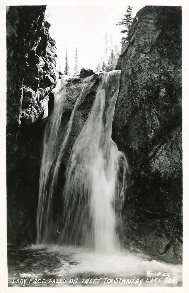
About Lady Face Falls
Lady Face Falls is a scenic cascade tucked into Idaho’s Challis National Forest and managed by the U.S. Forest Service. The waterfall sits along the Iron Creek - Stanley Lake route (USFS Trail #7640), and the Forest Service’s maps show a short mapped segment of roughly 0.11 miles in the immediate falls area. The setting is a pleasant forested stretch of trail that makes the falls a popular reward on a day hike through the national forest. The approach is a moderately paced out-and-back route — about 4.5 miles with roughly 500 feet of elevation gain — that suits most hikers who are comfortable on uneven ground. The USFS lists Trail #7640 as Class 3 with a native-material surface and typical grades of 12–20%, so expect some steeper pitches and sections with roots and rocks; sturdy footwear and steady footing make the visit more enjoyable. The route is managed by the U.S. Forest Service within Challis National Forest, making it an easy-to-find, well-documented outing for hikers exploring the area.
The Setting
Lady Face Falls sits at 6,617 feet within Challis National Forest, fed by the Valley Creek, in the high mountains of Idaho.
Trail & Hike Details
The Approach
The moderate hike follows Iron Creek Stanley Lake (#7640), a 4.5-mile out-and-back trail over natural surface. Expect 500 feet of elevation gain with grades of 12-20%. The trail is developed (Class 3).
USFS Trail
IRON CREEK - STANLEY LAKE #7640
Trail Class
Developed
Surface
Avg Grade
USFS Segment
0.11 miTrail Description
Trail begins from the Tin Cup area and follows the Iron Creek - Stanley Lake Trail (USFS Trail #7640). The hike is an out-and-back of about 4.5 miles total with approximately 500 feet of elevation gain and is rated moderate. According to USFS data, Trail #7640 is Class 3, has a native-material surface, and features typical grades of 12–20%, with a short USFS-mapped segment of about 0.11 miles near the falls. Expect uneven footing, intermittent steep pitches, and natural surface tread—good hiking shoes and caution on steeper sections are recommended.
What to Expect
Dogs are welcome.
Accessibility
The trail is not wheelchair accessible. Uneven terrain and elevation changes require steady footing.
Frequently Asked Questions
🐶 Are Dogs Allowed at Lady Face Falls?
✅ Dogs are allowed
Are There Any Fees or Permits Required?
🆖 No fees required
🏊 Is There Swimming at Lady Face Falls?
❌ Swimming is not allowed
When to Visit
The best time to visit Lady Face Falls is during late spring or early summer when the waterfall is at its fullest due to snowmelt. Fall also offers beautiful foliage, making it a great time for photography.
Seasonal Access
The best time to visit is Spring, Summer, and Fall. Access roads and trails may close during winter due to snow. Check with Challis National Forest for seasonal road closures.
Safety Information
Be prepared for changing weather conditions, as temperatures can drop quickly in the mountains. Carry a first aid kit and let someone know your hiking plans. Watch for loose rocks and slippery sections on the trail.
Current Water Conditions
351 ft³/s
Current discharge — how much water is flowing
About average for this time of year
Based on 88 years of record
1.60 ft
Water depth at gauge
7-Day Discharge Trend
What does this mean for your visit?
Flow is about average for this time of year.
About This Gauge
This gauge is on a nearby waterway and may not reflect exact conditions at the falls.
7-Day Flow Outlook
Based on the USGS gauge VALLEY CREEK AT STANLEY ID (13 km away).
Today
Roaring
396 cfs
6/10Tomorrow
Roaring
388 cfs
6/10Tue
Roaring
373 cfs
6/10Wed
Roaring
368 cfs
6/10Thu
Roaring
338 cfs
6/10Fri
Roaring
341 cfs
6/10Sat
Roaring
314 cfs
9/10Best window: Sat — roaring flow, sunny (trip score 9/10).
Best time of year: this gauge typically runs highest from mid April to mid July, peaking in June.
How we calculate this
This is a transparent outlook, not a precise forecast. We take the waterfall's current flow strength (how it ranks against its historical normal for today, from the nearest USGS stream gauge), carry that ranking forward along the gauge's seasonal curve, and nudge it for forecast rain. Confidence is highest for the next day or two and falls further out. Always check official conditions and your own judgment before visiting — high flows can be dangerous.
Know when to go.
Get a free email alert when waterfalls near Stanley hit peak flow. We only send when conditions are worth the trip — no weekly newsletters, no spam.
Weather Forecast
Location & Access
Getting There
Lady Face Falls is located near the Tin Cup Trailhead, which is accessible via Forest Road 208. The trailhead is approximately 20 miles from Stanley, Idaho. A high-clearance vehicle may be recommended for the last stretch of the road.
Get Directions on Google MapsParking
Parking is available at the Tin Cup Trailhead, but spaces may be limited during peak seasons.
Elevation
6,617 feet above sea level
Coordinates
44.231573° N, -115.095926° W
Land Management
Managed by USFS
Visitor Tips & Gear
Start your hike early in the day to avoid crowds and ensure you have enough daylight for the return trip. Wear sturdy hiking shoes and bring plenty of water, as the trail can be rocky in places. Check weather conditions before heading out, as the trail may be muddy or slippery after rain.
This trail sits at 6,617 ft above sea level
Elevated TrailUV radiation is roughly 26% stronger at this elevation than at sea level, and the dry air accelerates dehydration. Extra sun protection and fluids go a long way.
As an Amazon Associate, we earn from qualifying purchases.

Coppertone Sport SPF 50 Sunscreen
UV intensity jumps ~4% per 1,000 ft — at this elevation you can burn in half the time.

Sun Bum SPF 30 Lip Balm (3-Pack)
Lips have almost no natural UV protection and burn fast in thin, dry mountain air.

Liquid I.V. Electrolyte Packets
You lose moisture ~2x faster at elevation — electrolytes help you absorb water efficiently.

ROCKNIGHT Polarized UV400 Sunglasses
High-altitude glare off rock and water is intense — UV400 lenses block 99%+ of UVA/UVB.
As an Amazon Associate, we earn from qualifying purchases.
With 4.5 miles and 500 ft of elevation gain, sturdy boots and trekking poles will help on this moderate trail. Sun exposure on the trail makes good sun protection a must in summer.

Polarized Sunglasses (Knockaround)
Cuts glare off the water so you actually see the falls — and your photos turn out better too.

Columbia Watertight II Rain Jacket
Packs into its own pocket, seam-sealed, and keeps you dry from spray and surprise rain.

Earth Pak Waterproof Dry Bag
Keeps your phone and gear dry when waterfall mist soaks everything else.

Waterproof Phone Pouch (AiRunTech)
Cheap insurance — take photos right next to the falls without killing your phone.

Timberland Euro Sprint Mid Waterproof
Trusted waterproof boot with premium leather and grippy rubber sole — reliable on rocky, wet trails.

TrailBuddy Trekking Poles
Lightweight aluminum, cork grips, and flip-locks that actually hold — a best-seller for good reason.
Where to Stay

Redfish Riverside Inn

Stanley High Country Inn

Stanley Spacious Home with Panoramic Views

Timberhaven Cabin
Browse vacation cabins and private rentals nearby
Unique outdoor stays — tents, yurts, and treehouses
Rent a campervan or RV for your waterfall road trip
Some links are affiliate links. We may earn a commission at no extra cost to you.
Nearby Campground
CAPE HORN WINTER RENTAL
9.8 miles away · 1 sites
Overview Cape Horn Winter Rental is located in beautiful Elk Meadow, approximately 16 miles northwest of Stanley, in central Idaho. It sits at an elevation of 6,660 feet. Guests enjoy the area for its endless winter recreation opportunities, including cross-country skiing, back country downhill skiing, snowshoeing and snowmobiling.Recreation The Cape Horn area offers unlimited cross-country skiing, snowshoeing, and snowmobiling opportunities in the surrounding meadows, and downhill skiing is avai
Book on Recreation.govNearby Hot Springs
Hot springs near Stanley, Idaho
Grandjean Hot Spring
Grandjean Hot Spring sits at 5,000 feet in the Boise National Forest, just 60 feet from the road in some of the most dramatic h...
Sacajawea Hot Springs
Sacajawea Hot Springs blasts out at 153 degrees Fahrenheit at 5,000 feet elevation in the Boise National Forest, making it dang...

Stanley Hot Spring
Stanley Hot Spring sits just 66 feet from the Salmon River Scenic Byway at 6,220 feet elevation, making it one of the easiest t...
Elkhorn Hot Spring
Elkhorn Hot Spring, better known locally as Boat Box Hot Spring, delivers 136-degree water into a metal soaking tub built into ...
Cape Horn Warm Springs
Cape Horn Warm Springs sits at 6,555 feet in Boise County, one of the higher thermal features near Idaho City, producing 95-deg...

Mormon Bend Hot Spring
Mormon Bend Hot Spring flows at exactly 100 degrees Fahrenheit along the Salmon River Scenic Byway in Custer County, hitting th...
Looking for a soak after your hike? Explore more hot springs near Stanley, Idaho on SoakingSprings.
Explore Idaho springsAdditional Information
Nearby Attractions
Other nearby attractions include Alice Lake and Pettit Lake, both of which offer additional hiking and camping opportunities.
Wildlife
The area is home to a variety of wildlife, including deer, squirrels, and birds. Be cautious of bears and carry bear spray if hiking in the area.
Cities near Lady Face Falls
Nearby Waterfalls
Writing about Lady Face Falls? Embed this waterfall on your site for free.