Difficulty
Moderate
Trail Length
2.0 miles
Trail Type
Out And Back
Elevation Gain
300 ft
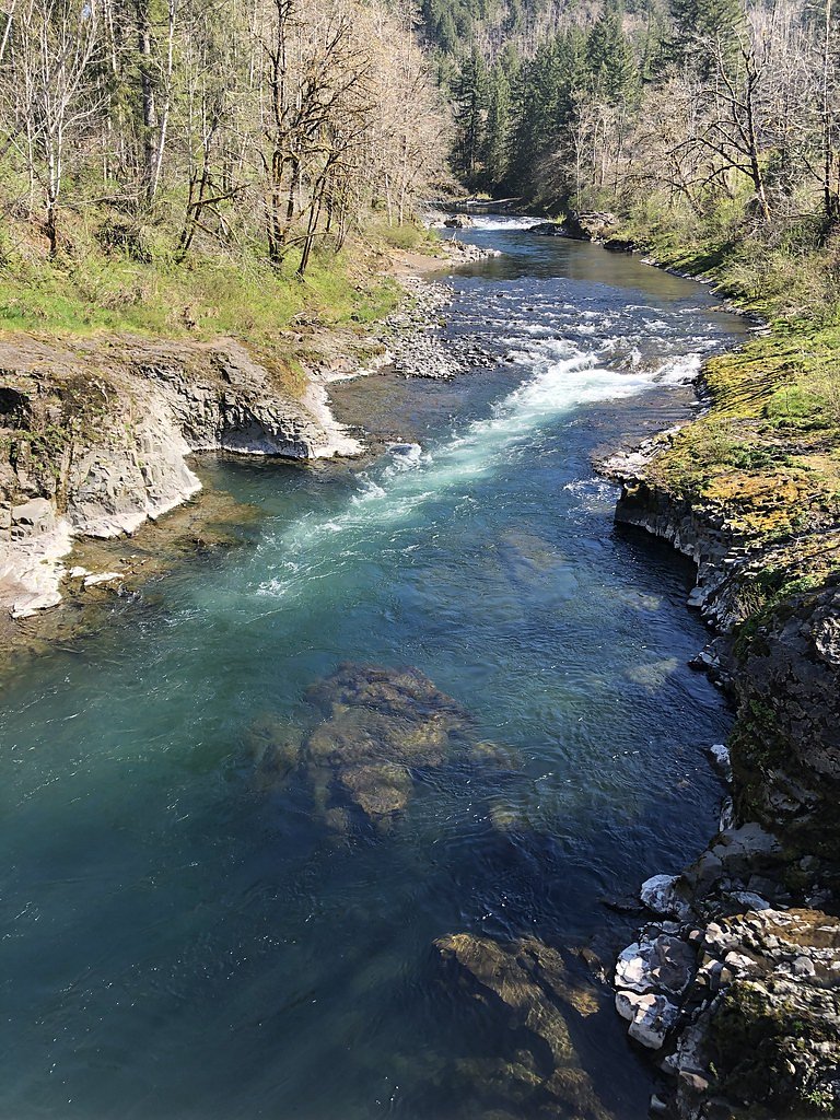
About Kilchis Falls
Kilchis Falls is a remote, lesser-known cascade tucked into the dense timber of Tillamook State Forest along the Kilchis River, offering a peaceful, secluded stop for hikers who prefer quieter trails. The falls sit on state-managed forestland and are framed by mossy rock and coastal timber, creating a picture-perfect spot for a short nature outing. The site lies on lands owned by SDNR and managed by SLB under the Forest Development Fund (Board of Forestry), and the area carries an SRMA designation. The hike to the falls is short but rewarding: expect a roughly 2.0-mile out-and-back with about 300 feet of elevation gain. The route is rated moderate and is not heavily trafficked, so it’s a great option for a tranquil day hike; however, some sections are narrow and uneven, so sturdy footwear and careful footing are recommended.
The Setting
Kilchis Falls sits at 1,332 feet within Forest Development Fund (Board Of Forestry), fed by the Nehalem River, in the foothills of Oregon.
Trail & Hike Details
The Approach
The moderate 2.0-mile out-and-back trail gains 300 feet of elevation on the way to the falls.
Trail Description
Out-and-back trail approximately 2.0 miles in length with about 300 feet of elevation gain; difficulty: moderate. The path winds through dense forest and is generally a natural, single-route tread—narrow and uneven in places—which keeps the experience feeling remote and peaceful. Formal USFS trail surface/grade/class data are not provided for this route; based on conditions, the trail is non-technical but requires steady footing and attention on steeper or constricted sections. The route traverses SDNR lands managed under the Forest Development Fund (Board of Forestry) with SLB as manager and is within an SRMA.
What to Expect
Dogs are welcome.
Accessibility
The trail is not wheelchair accessible. Uneven terrain and elevation changes require steady footing.
Frequently Asked Questions
🐶 Are Dogs Allowed at Kilchis Falls?
✅ Dogs are allowed
Are There Any Fees or Permits Required?
🆖 No fees required
🏊 Is There Swimming at Kilchis Falls?
❌ Swimming is not allowed
When to Visit
Spring and early summer are ideal times to visit, as the waterfall flow is typically strongest due to seasonal rainfall and snowmelt.
Seasonal Access
The best time to visit is Spring, Summer, and Fall. Winter access may be limited.
Safety Information
The trail can be slippery and muddy, especially after rain. Visitors should exercise caution and avoid hiking alone. Cell service is limited, so inform someone of your plans before heading out.
Current Water Conditions
283 ft³/s
Current discharge — how much water is flowing
Lower than usual for this time of year
Based on 84 years of record
2.08 ft
Water depth at gauge
68°F
CoolRefreshing for swimming
7-Day Discharge Trend
What does this mean for your visit?
Flow is lower than usual for this time of year. Water temperature is a refreshing 68 degrees F, good for a quick swim.
About This Gauge
This gauge is on a nearby waterway and may not reflect exact conditions at the falls.
7-Day Flow Outlook
Based on the USGS gauge NEHALEM RIVER NEAR FOSS, OR (14 km away).
Today
Low
306 cfs
4/10Tomorrow
Low
317 cfs
4/10Sun
Low
317 cfs
4/10Mon
Low
317 cfs
4/10Tue
Low
317 cfs
4/10Wed
Low
317 cfs
4/10Thu
Low
317 cfs
4/10Best window: Today — low flow, rain showers (trip score 4/10).
How we calculate this
This is a transparent outlook, not a precise forecast. We take the waterfall's current flow strength (how it ranks against its historical normal for today, from the nearest USGS stream gauge), carry that ranking forward along the gauge's seasonal curve, and nudge it for forecast rain. Confidence is highest for the next day or two and falls further out. Always check official conditions and your own judgment before visiting — high flows can be dangerous.
Know when to go.
Get a free email alert when waterfalls near Barnesdale hit peak flow. We only send when conditions are worth the trip — no weekly newsletters, no spam.
Weather Forecast
Location & Access
Getting There
Kilchis Falls is located in the Tillamook State Forest, Oregon. Accessing the falls typically requires navigating forest roads, which may be unpaved and rough. Visitors should use a reliable map or GPS, as signage is limited.
Get Directions on Google MapsParking
Parking is limited and may involve roadside parking near the trailhead. Visitors should ensure they do not block access roads.
Elevation
1,332 feet above sea level
Coordinates
45.605387° N, -123.651233° W
Land Management
Managed by SLB
Visitor Tips & Gear
Wear sturdy hiking shoes, as the trail can be uneven and muddy, especially after rain. Bring plenty of water and snacks, as there are no facilities nearby. A GPS device or offline map is recommended due to limited cell service in the area.
As an Amazon Associate, we earn from qualifying purchases.
With 2.0 miles and 300 ft of elevation gain, sturdy boots and trekking poles will help on this moderate trail. Sun exposure on the trail makes good sun protection a must in summer.

Columbia Watertight II Rain Jacket
Packs into its own pocket, seam-sealed, and keeps you dry from spray and surprise rain.

Earth Pak Waterproof Dry Bag
Keeps your phone and gear dry when waterfall mist soaks everything else.

Waterproof Phone Pouch (AiRunTech)
Cheap insurance — take photos right next to the falls without killing your phone.

Timberland Euro Sprint Mid Waterproof
Trusted waterproof boot with premium leather and grippy rubber sole — reliable on rocky, wet trails.

TrailBuddy Trekking Poles
Lightweight aluminum, cork grips, and flip-locks that actually hold — a best-seller for good reason.

Polarized Sunglasses (Knockaround)
Cuts glare off the water so you actually see the falls — and your photos turn out better too.
Where to Stay

2 Bed 2 Bath Vacation home in Rockaway Beach

The Tillamook Inn

Inn at Cannon Beach

Rockaway oceanview condo,Steps to the beach & Downtown,W&D, WiFi
Browse vacation cabins and private rentals nearby
Unique outdoor stays — tents, yurts, and treehouses
Rent a campervan or RV for your waterfall road trip
Some links are affiliate links. We may earn a commission at no extra cost to you.
Nearby Campground
Dovre Recreation Site
21.7 miles away · 11 sites
Overview Want to camp? Camping season is generally May-September, with Alder Glen and Elk Bend remaining open through the weekend following General Western Oregon Coast 2nd Season for elk. During months with reduced sunlight, potable water may be turned off. Be prepared to bring your own wash and drinking water. Reserve a site at one of our four campgrounds on recreation.gov or pay when you arrive for non-reserved campsites using the Recreation.gov Mobile App. You must download before you reach t
Book on Recreation.govAdditional Information
Nearby Attractions
Nearby attractions include the Tillamook Forest Center and other hiking trails in the Tillamook State Forest.
Wildlife
The area is home to a variety of wildlife, including deer, birds, and small mammals. Visitors should be cautious of potential encounters with bears or cougars.
Cities near Kilchis Falls
Nearby Waterfalls
Writing about Kilchis Falls? Embed this waterfall on your site for free.