Difficulty
Moderate
Trail Length
2.0 miles
Trail Type
Out And Back
Elevation Gain
300 ft
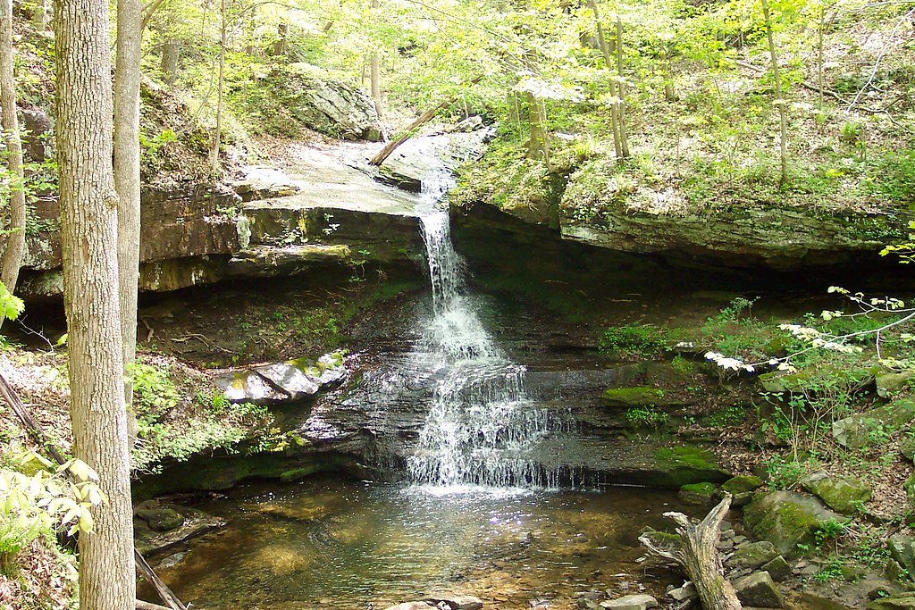
About Jumpoff Falls
Jumpoff Falls is a lesser-known waterfall located in Tennessee, offering a serene and secluded experience for visitors. It is surrounded by lush forest and is part of the Cumberland Plateau region, known for its rugged terrain and natural beauty.
The Setting
Jumpoff Falls sits at 1,716 feet along the Elk River, in the hills of Tennessee.
Nearby Falls Worth Visiting
Foster Falls (60 ft) lies 9.8 miles to the east. Also nearby: Deer Lick Falls (15 ft, 9.3 mi).
Trail & Hike Details
The Approach
The moderate 2.0-mile out-and-back trail gains 300 feet of elevation on the way to the falls.
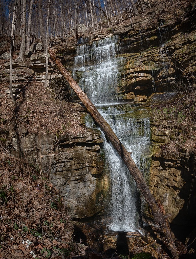
Trail Description
The trail to Jumpoff Falls winds through dense forest and features rocky terrain typical of the Cumberland Plateau. Hikers may encounter uneven paths and some steep sections, making sturdy footwear essential.
What to Expect
Visitors can expect a peaceful hike through a forested area leading to a picturesque waterfall. The falls may vary in flow depending on recent rainfall, with spring and early summer offering the best water levels.
Accessibility
The trail is not wheelchair accessible. Uneven terrain and elevation changes require steady footing.
Frequently Asked Questions
🐶 Are Dogs Allowed at Jumpoff Falls?
❌ Dogs are not allowed
Are There Any Fees or Permits Required?
🆖 No fees required
🏊 Is There Swimming at Jumpoff Falls?
❌ Swimming is not allowed
When to Visit
Spring and early summer are ideal for visiting Jumpoff Falls, as the water flow is typically strongest during these seasons.
Seasonal Access
The best time to visit is Spring, Summer, and Fall. Winter access may be limited.
Safety Information
The trail can be slippery after rain, and there may be steep drop-offs near the falls. Exercise caution and stay on marked trails. Cell phone service may be limited in the area.
Current Water Conditions
16 ft³/s
Current discharge — how much water is flowing
About average for this time of year
Based on 61 years of record
1.81 ft
Water depth at gauge
7-Day Discharge Trend
What does this mean for your visit?
Flow is about average for this time of year.
About This Gauge
This gauge is on a nearby waterway and may not reflect exact conditions at the falls.
7-Day Flow Outlook
Based on the USGS gauge ELK RIVER NEAR PELHAM, TN (17 km away).
Today
Low
19 cfs
3/10Tomorrow
Low
23 cfs
3/10Sat
Low
21 cfs
3/10Sun
Low
23 cfs
3/10Mon
Low
23 cfs
3/10Tue
Low
20 cfs
3/10Wed
Low
20 cfs
3/10Best window: Today — low flow, patchy fog then chance showers and thunderstorms (trip score 3/10).
Best time of year: this gauge typically runs highest from mid February to late March, peaking in January.
How we calculate this
This is a transparent outlook, not a precise forecast. We take the waterfall's current flow strength (how it ranks against its historical normal for today, from the nearest USGS stream gauge), carry that ranking forward along the gauge's seasonal curve, and nudge it for forecast rain. Confidence is highest for the next day or two and falls further out. Always check official conditions and your own judgment before visiting — high flows can be dangerous.
Know when to go.
Get a free email alert when waterfalls near Monteagle hit peak flow. We only send when conditions are worth the trip — no weekly newsletters, no spam.
Weather Forecast
Location & Access
Getting There
Jumpoff Falls is located near Sewanee, Tennessee, within the South Cumberland State Park area. Access may require navigating forest roads or trails, so visitors should check local maps and trail guides for the most accurate directions.
Get Directions on Google MapsParking
Parking availability is unclear, but visitors may need to park at nearby trailheads or designated areas within South Cumberland State Park.
Elevation
1,716 feet above sea level
Coordinates
35.142855° N, -85.842459° W
Visitor Tips & Gear
Start your hike early to avoid crowds and ensure you have enough daylight. Bring plenty of water, as the trail can be moderately challenging. Check weather conditions before your visit, as rain can make the trail slippery.
As an Amazon Associate, we earn from qualifying purchases.
With 2.0 miles and 300 ft of elevation gain, sturdy boots and trekking poles will help on this moderate trail. Sun exposure on the trail makes good sun protection a must in summer.

Columbia Watertight II Rain Jacket
Packs into its own pocket, seam-sealed, and keeps you dry from spray and surprise rain.

Earth Pak Waterproof Dry Bag
Keeps your phone and gear dry when waterfall mist soaks everything else.

Waterproof Phone Pouch (AiRunTech)
Cheap insurance — take photos right next to the falls without killing your phone.

Timberland Euro Sprint Mid Waterproof
Trusted waterproof boot with premium leather and grippy rubber sole — reliable on rocky, wet trails.

TrailBuddy Trekking Poles
Lightweight aluminum, cork grips, and flip-locks that actually hold — a best-seller for good reason.

Polarized Sunglasses (Knockaround)
Cuts glare off the water so you actually see the falls — and your photos turn out better too.
Where to Stay

Spark by Hilton Kimball

Hampton Inn Kimball

Quality Inn Monteagle

Quality Inn & Suites Jasper - Kimball
Browse vacation cabins and private rentals nearby
Unique outdoor stays — tents, yurts, and treehouses
Rent a campervan or RV for your waterfall road trip
Some links are affiliate links. We may earn a commission at no extra cost to you.
Additional Information
Nearby Attractions
Nearby attractions include other waterfalls and trails within South Cumberland State Park, such as Foster Falls and the Fiery Gizzard Trail.
Wildlife
The area is home to a variety of wildlife, including deer, birds, and small mammals. Visitors should also be aware of snakes and other potentially hazardous animals.
Cities near Jumpoff Falls
Nearby Waterfalls
Writing about Jumpoff Falls? Embed this waterfall on your site for free.