
Photo Credits (1)
Difficulty
Moderate
Trail Length
2.4 miles
Trail Type
Out And Back
Elevation Gain
350 ft
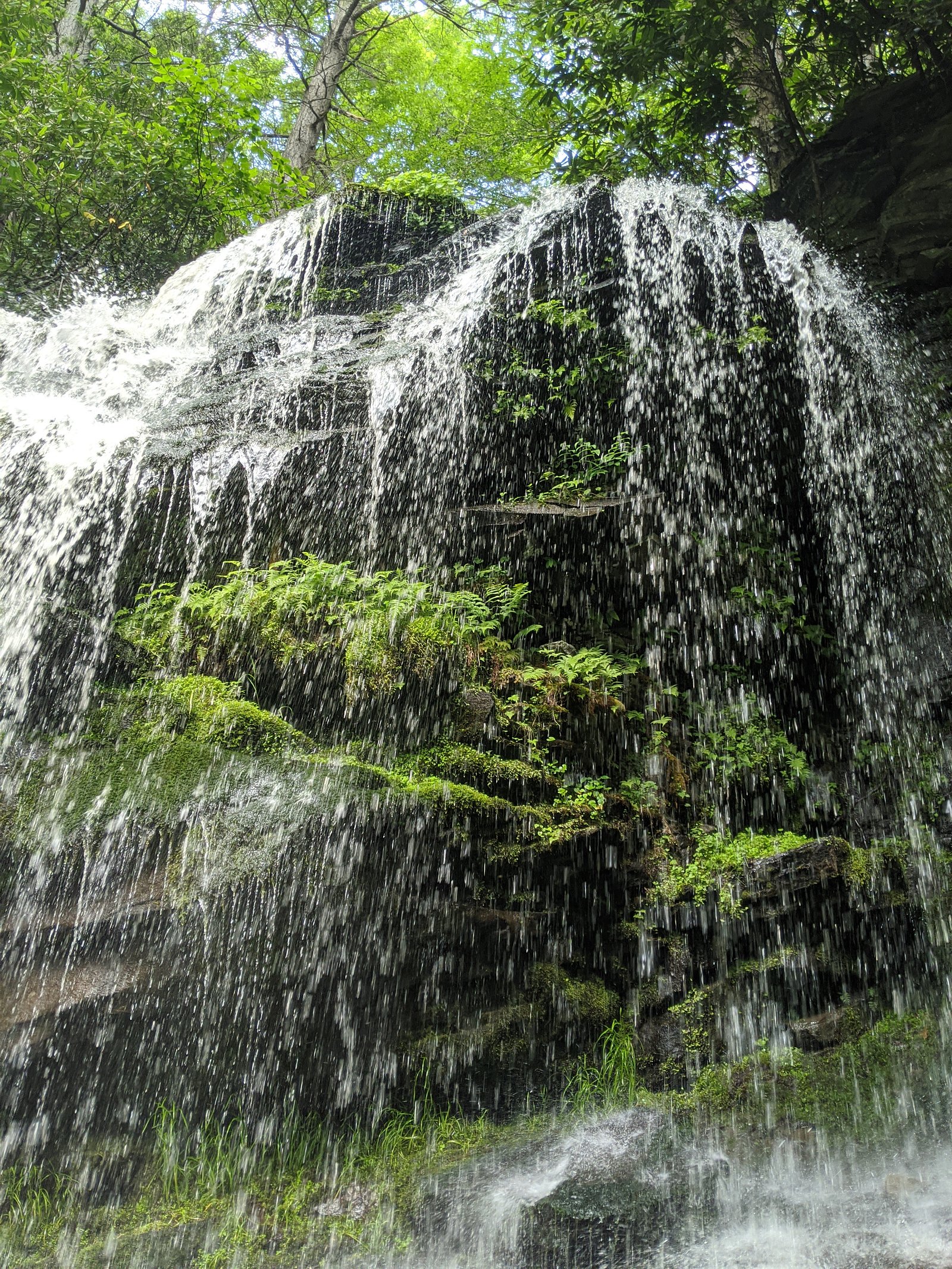
About Denton Falls
Denton Falls is a quietly scenic cascade tucked inside the Neversink River Unique Area in New York. Owned and managed by OTHS, the falls are a lesser-known gem set among riparian forest and shaded banks, making it a peaceful destination for photographers, birders, and hikers who prefer a more secluded outdoor experience. Access to the falls is via a roughly 2.4-mile out-and-back route that climbs about 350 feet and is generally rated moderate. Official USFS trail surface, grade, and class data are not available for this access route, so come prepared with sturdy footwear, basic navigation aids, and a leave-no-trace mindset when exploring this pleasant, tucked-away spot.
The Setting
Denton Falls sits at 935 feet within Neversink River Unique Area, fed by the Neversink River, in the foothills of New York.
Trail & Hike Details
The Approach
The moderate 2.4-mile out-and-back trail gains 350 feet of elevation on the way to the falls.
Trail Description
This approach to Denton Falls is a 2.4-mile out-and-back hike with approximately 350 feet of elevation gain and a moderate difficulty rating. Detailed USFS trail surface, grade, and trail class information is not available for this route; the hike is best treated as a natural-surface forest path with potentially uneven sections. Hikers should plan for steady climbs on the outbound leg, bring proper footwear and navigation, and expect some informal or lightly marked stretches along the way.
What to Expect
Visitors can expect a peaceful and scenic waterfall surrounded by natural beauty. The area is relatively quiet and less crowded compared to more popular waterfalls. However, access may be challenging due to the lack of formal trails.
Accessibility
The trail is not wheelchair accessible. Uneven terrain and elevation changes require steady footing.
Frequently Asked Questions
🐶 Are Dogs Allowed at Denton Falls?
❌ Dogs are not allowed
Are There Any Fees or Permits Required?
🆖 No fees required
🏊 Is There Swimming at Denton Falls?
❌ Swimming is not allowed
When to Visit
Spring and early summer are ideal times to visit Denton Falls, as the water flow is typically stronger due to snowmelt and rainfall.
Seasonal Access
The best time to visit is Spring, Summer, and Fall. Winter access may be limited.
Safety Information
Exercise caution near the water, as rocks may be slippery and the river currents can be strong. Cell phone service may be limited in the area, so plan accordingly.
Current Water Conditions
133 ft³/s
Current discharge — how much water is flowing
About average for this time of year
Based on 33 years of record
4.90 ft
Water depth at gauge
62°F
CoolRefreshing for swimming
7-Day Discharge Trend
What does this mean for your visit?
Flow is about average for this time of year. Water temperature is a refreshing 62 degrees F, good for a quick swim.
About This Gauge
7-Day Flow Outlook
Based on the USGS gauge NEVERSINK RIVER AT BRIDGEVILLE NY (8 km away).
Today
Moderate
144 cfs
6/10Tomorrow
Strong
163 cfs
7/10Mon
Moderate
141 cfs
9/10Tue
Strong
148 cfs
7/10Wed
Moderate
133 cfs
9/10Thu
Moderate
133 cfs
9/10Fri
Strong
150 cfs
7/10Best window: Mon — moderate flow, sunny (trip score 9/10).
Best time of year: this gauge typically runs highest from early March to mid April, peaking in April.
How we calculate this
This is a transparent outlook, not a precise forecast. We take the waterfall's current flow strength (how it ranks against its historical normal for today, from the nearest USGS stream gauge), carry that ranking forward along the gauge's seasonal curve, and nudge it for forecast rain. Confidence is highest for the next day or two and falls further out. Always check official conditions and your own judgment before visiting — high flows can be dangerous.
Know when to go.
Get a free email alert when waterfalls near Bridgeville hit peak flow. We only send when conditions are worth the trip — no weekly newsletters, no spam.
Weather Forecast
Location & Access
Getting There
Denton Falls is located near the town of Hancock, New York. Access is typically via local roads, and visitors should use GPS or maps to navigate to the area. The falls are situated along the Delaware River, and access may require walking along unmarked paths or riverbanks.
Get Directions on Google MapsParking
Parking availability is limited and may be informal, such as roadside pull-offs. Visitors should plan accordingly and ensure they are not blocking traffic or private property.
Elevation
935 feet above sea level
Coordinates
41.566481° N, -74.632383° W
Land Management
Managed by OTHS
Visitor Tips & Gear
Wear sturdy footwear as the terrain may be uneven. Bring a map or GPS device as the area is not well-marked. Be cautious of slippery rocks near the water.
As an Amazon Associate, we earn from qualifying purchases.
With 2.4 miles and 350 ft of elevation gain, sturdy boots and trekking poles will help on this moderate trail. Sun exposure on the trail makes good sun protection a must in summer.

Polarized Sunglasses (Knockaround)
Cuts glare off the water so you actually see the falls — and your photos turn out better too.

Columbia Watertight II Rain Jacket
Packs into its own pocket, seam-sealed, and keeps you dry from spray and surprise rain.

Earth Pak Waterproof Dry Bag
Keeps your phone and gear dry when waterfall mist soaks everything else.

Waterproof Phone Pouch (AiRunTech)
Cheap insurance — take photos right next to the falls without killing your phone.

Timberland Euro Sprint Mid Waterproof
Trusted waterproof boot with premium leather and grippy rubber sole — reliable on rocky, wet trails.

TrailBuddy Trekking Poles
Lightweight aluminum, cork grips, and flip-locks that actually hold — a best-seller for good reason.
Where to Stay

Hampton Inn Monticello, Ny

Days Inn by Wyndham Wurtsboro

Best Western Monticello

Sleep Inn & Suites Middletown - Goshen
Browse vacation cabins and private rentals nearby
Unique outdoor stays — tents, yurts, and treehouses
Rent a campervan or RV for your waterfall road trip
Some links are affiliate links. We may earn a commission at no extra cost to you.
Additional Information
Nearby Attractions
The town of Hancock offers small-town charm and access to the Delaware River for fishing and kayaking.
Wildlife
The area around Denton Falls is home to various bird species, deer, and other wildlife typical of the region.
Cities near Denton Falls
Nearby Waterfalls
Writing about Denton Falls? Embed this waterfall on your site for free.