Difficulty
Moderate
Trail Length
2.4 miles
Trail Type
Out And Back
Elevation Gain
350 ft
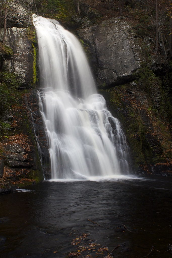
About Bass Lake Falls
Bass Lake Falls is a peaceful, lesser-known cascade tucked into the Princeton Blairstown Center (PCON), a conservation parcel owned and managed by a nonprofit organization. The falls sit amid quiet woodland and offer a serene destination for hikers seeking a short nature escape—ideal for photographers, birders, and anyone wanting a low-key waterfall visit without the crowds. Access to the falls and surrounding trails is provided on land stewarded by the Princeton Blairstown Center (managed by an NGO), and primitive camping is nearby at Alosa Campsites, roughly 6.98 km from the trailhead for those who want to extend their visit. The setting invites a relaxed outing while supporting local conservation efforts that protect the watershed and trails in this pocket of New Jersey countryside.
The Setting
Bass Lake Falls sits at 755 feet within Princeton Blairstown Center, fed by the Paulins Kill, in the foothills of New Jersey.
Trail & Hike Details
The Approach
The moderate 2.4-mile out-and-back trail gains 350 feet of elevation on the way to the falls.
Trail Description
The hike to Bass Lake Falls is an out-and-back route of about 2.4 miles round trip with roughly 350 feet of elevation gain, rated moderate. The route follows a natural, wooded footpath with a steady moderate grade—suitable for hikers who are comfortable with uneven, non-paved terrain and short climbs. Trail signage and conditions can vary, so plan for basic trail navigation and wear sturdy footwear; the relatively short distance makes this a good half-day option from nearby Alosa Campsites (≈6.98 km).
What to Expect
Dogs are welcome.
Accessibility
The trail is not wheelchair accessible. Uneven terrain and elevation changes require steady footing.
Frequently Asked Questions
🐶 Are Dogs Allowed at Bass Lake Falls?
✅ Dogs are allowed
Are There Any Fees or Permits Required?
🆖 No fees required
🏊 Is There Swimming at Bass Lake Falls?
❌ Swimming is not allowed
When to Visit
Spring and early summer are ideal for visiting, as the waterfall flow is typically strongest during these seasons.
Seasonal Access
The best time to visit is Spring, Summer, and Fall. Winter access may be limited.
Safety Information
Exercise caution near the waterfall, as rocks can be slippery. Be aware of ticks and other wildlife. Avoid visiting during heavy rain or icy conditions.
Current Water Conditions
74 ft³/s
Current discharge — how much water is flowing
About average for this time of year
Based on 103 years of record
1.63 ft
Water depth at gauge
7-Day Discharge Trend
What does this mean for your visit?
Flow is about average for this time of year.
About This Gauge
7-Day Flow Outlook
Based on the USGS gauge Paulins Kill at Blairstown NJ (5 km away).
Today
Moderate
74 cfs
8/10Tomorrow
Moderate
71 cfs
8/10Thu
Moderate
72 cfs
8/10Fri
Moderate
86 cfs
6/10Sat
Moderate
83 cfs
6/10Sun
Moderate
82 cfs
6/10Mon
Moderate
82 cfs
6/10Best window: Today — moderate flow, mostly sunny (trip score 8/10).
Best time of year: this gauge typically runs highest from mid February to early May, peaking in March.
How we calculate this
This is a transparent outlook, not a precise forecast. We take the waterfall's current flow strength (how it ranks against its historical normal for today, from the nearest USGS stream gauge), carry that ranking forward along the gauge's seasonal curve, and nudge it for forecast rain. Confidence is highest for the next day or two and falls further out. Always check official conditions and your own judgment before visiting — high flows can be dangerous.
Know when to go.
Get a free email alert when waterfalls near Marksboro hit peak flow. We only send when conditions are worth the trip — no weekly newsletters, no spam.
Weather Forecast
Location & Access
Getting There
Bass Lake Falls is located near the Delaware Water Gap area in New Jersey. Access typically involves driving to a nearby parking area and hiking a short trail to the falls.
Get Directions on Google MapsParking
Parking is available near the trailhead, but spaces may be limited during peak seasons.
Elevation
755 feet above sea level
Coordinates
41.023153° N, -74.952950° W
Land Management
Managed by NGO
Visitor Tips & Gear
Visit early in the day to avoid crowds and secure parking. Wear sturdy shoes as the trail may be muddy or slippery after rain.
As an Amazon Associate, we earn from qualifying purchases.
With 2.4 miles and 350 ft of elevation gain, sturdy boots and trekking poles will help on this moderate trail. Sun exposure on the trail makes good sun protection a must in summer.

Columbia Watertight II Rain Jacket
Packs into its own pocket, seam-sealed, and keeps you dry from spray and surprise rain.

Earth Pak Waterproof Dry Bag
Keeps your phone and gear dry when waterfall mist soaks everything else.

Waterproof Phone Pouch (AiRunTech)
Cheap insurance — take photos right next to the falls without killing your phone.

Timberland Euro Sprint Mid Waterproof
Trusted waterproof boot with premium leather and grippy rubber sole — reliable on rocky, wet trails.

TrailBuddy Trekking Poles
Lightweight aluminum, cork grips, and flip-locks that actually hold — a best-seller for good reason.

Polarized Sunglasses (Knockaround)
Cuts glare off the water so you actually see the falls — and your photos turn out better too.
Where to Stay

Pocono Mountain Villas MOD Collection by Sonesta

Serenity Falls - Stylish 4Bdr Mountain Retreat, Hot Tub, Pool

The Penn Stroud, Stroudsburg - Poconos, an Ascend Collection Hotel

Hampton Inn & Suites Stroudsburg Bartonsville Poconos
Browse vacation cabins and private rentals nearby
Unique outdoor stays — tents, yurts, and treehouses
Rent a campervan or RV for your waterfall road trip
Some links are affiliate links. We may earn a commission at no extra cost to you.
Nearby Campground
Alosa Campsites
4.3 miles away · 6 sites
Overview The Alosa Campsites are boat-in only sites located on the west (Pennsylvanian) shore of the Delaware River near Bushkill, Pennsylvania. The side of the river with the campsites will be on your right while traveling downstream. This section of the river offers unspoiled views, excellent boating, fishing, and birding opportunities within the Delaware Water Gap National Recreation Area and the Middle Delaware National Scenic and Recreational River. These reservation-only campsites are avail
Book on Recreation.govAdditional Information
Nearby Attractions
The Delaware Water Gap National Recreation Area offers additional hiking trails, scenic overlooks, and waterfalls to explore.
Wildlife
The area is home to various bird species, deer, and small mammals. Visitors may also encounter insects such as mosquitoes and ticks.
Cities near Bass Lake Falls
Nearby Waterfalls
Writing about Bass Lake Falls? Embed this waterfall on your site for free.