Bailey Falls
By Armen Suny · Last verified May 2026
Difficulty
Moderate
Trail Length
2.4 miles
Trail Type
Out And Back
Elevation Gain
350 ft
About Bailey Falls
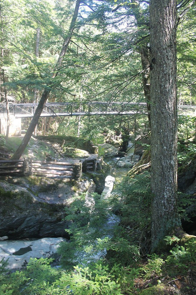
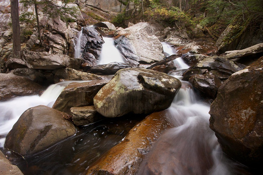
Bailey Falls is a peaceful, lesser-known cascade tucked into Vermont’s forested hills, reached by a short, rewarding hike that threads through leafy woods. The falls make a lovely early-morning or late-afternoon destination for photographers and anyone seeking a gentle nature escape — the sound of tumbling water and a quiet viewing spot reward the modest effort. The approach is a 2.4-mile out-and-back trail with about 350 feet of elevation gain and a moderate rating, a manageable day hike for most walkers who are comfortable with some uphill and uneven footing. If you want to turn the visit into an overnight trip, Bingo Campground sits about 6.1 km (under 4 miles) from the falls, offering nearby camping for those who want to stay close and explore more of the surrounding woods.
The Setting
Bailey Falls sits at 1,657 feet along the Otter Creek, in the hills of Vermont.
Nearby Falls Worth Visiting
Moss Glen Falls (35 ft) lies 7.9 miles to the northeast.
Trail & Hike Details
The Approach
The moderate 2.4-mile out-and-back trail gains 350 feet of elevation on the way to the falls.
Trail Description
Trail type: out-and-back. Distance: 2.4 miles (round trip). Elevation gain: ~350 feet. Difficulty: moderate. The route follows a wooded footpath with natural tread—expect roots, rocks and occasional uneven or muddy sections rather than paved or heavily maintained surfacing. The grade is generally moderate rather than steep, so sturdy footwear and basic trail awareness are recommended. The trail leads directly to a small viewing area at the falls; return the same way.
What to Expect
Dogs are welcome.
Accessibility
The trail is not wheelchair accessible. Uneven terrain and elevation changes require steady footing.
Frequently Asked Questions
🐶 Are Dogs Allowed at Bailey Falls?
✅ Dogs are allowed
Are There Any Fees or Permits Required?
🆖 No fees required
🏊 Is There Swimming at Bailey Falls?
❌ Swimming is not allowed
When to Visit
Spring and early summer are the best times to visit, as the waterfall is typically at its fullest due to snowmelt and rainfall.
Seasonal Access
The best time to visit is Spring, Summer, and Fall. Winter access may be limited.
Safety Information
Exercise caution near the waterfall, as rocks can be slippery. Be aware of changing weather conditions and avoid visiting during heavy rain or storms.
Current Water Conditions
1,790 ft³/s
Current discharge — how much water is flowing
Much higher than usual for this time of year
Based on 110 years of record
3.55 ft
Water depth at gauge
7-Day Discharge Trend
What does this mean for your visit?
The water is flowing much higher than usual, expect an impressive display.
About This Gauge
This gauge is on a nearby waterway and may not reflect exact conditions at the falls.
7-Day Flow Outlook
Based on the USGS gauge OTTER CREEK AT MIDDLEBURY, VT (20 km away).
Today
Low
1790 cfs
6/10Tomorrow
Moderate
1889 cfs
4/10Wed
Moderate
2052 cfs
4/10Thu
Moderate
1910 cfs
4/10Fri
Moderate
1792 cfs
4/10Sat
Moderate
1812 cfs
4/10Sun
Moderate
1673 cfs
5/10Best window: Today — low flow, sunny (trip score 6/10).
Best time of year: this gauge typically runs highest from early March to late May, peaking in April.
How we calculate this
This is a transparent outlook, not a precise forecast. We take the waterfall's current flow strength (how it ranks against its historical normal for today, from the nearest USGS stream gauge), carry that ranking forward along the gauge's seasonal curve, and nudge it for forecast rain. Confidence is highest for the next day or two and falls further out. Always check official conditions and your own judgment before visiting — high flows can be dangerous.
Know when to go.
Get a free email alert when waterfalls near South Lincoln hit peak flow. We only send when conditions are worth the trip — no weekly newsletters, no spam.
Weather Forecast
Location & Access
Getting There
Bailey Falls is located near the town of Jamaica, Vermont. Access may require driving on rural roads, and visitors should check local maps or GPS for the most accurate directions.
Get Directions on Google MapsParking
Parking availability is limited and may consist of roadside pull-offs or small parking areas. Visitors should plan accordingly and avoid blocking traffic.
Elevation
1,657 feet above sea level
Coordinates
43.925897° N, -72.943167° W
Visitor Tips & Gear
Visit early in the day to avoid crowds and ensure parking availability. Bring insect repellent during warmer months, as bugs may be present. Be cautious of slippery rocks near the waterfall.
As an Amazon Associate, we earn from qualifying purchases.
With 2.4 miles and 350 ft of elevation gain, sturdy boots and trekking poles will help on this moderate trail. Sun exposure on the trail makes good sun protection a must in summer.

Columbia Watertight II Rain Jacket
Packs into its own pocket, seam-sealed, and keeps you dry from spray and surprise rain.

Earth Pak Waterproof Dry Bag
Keeps your phone and gear dry when waterfall mist soaks everything else.

Waterproof Phone Pouch (AiRunTech)
Cheap insurance — take photos right next to the falls without killing your phone.

Timberland Euro Sprint Mid Waterproof
Trusted waterproof boot with premium leather and grippy rubber sole — reliable on rocky, wet trails.

TrailBuddy Trekking Poles
Lightweight aluminum, cork grips, and flip-locks that actually hold — a best-seller for good reason.

Polarized Sunglasses (Knockaround)
Cuts glare off the water so you actually see the falls — and your photos turn out better too.
Where to Stay

Cedarbrook Queen Studio 110

Cedarbrook Queen Suite 108

Ski in/out Spruce Glen Townhomes on Great Eastern Trail

Cedarbrook Queen Studio 210
Browse vacation cabins and private rentals nearby
Unique outdoor stays — tents, yurts, and treehouses
Rent a campervan or RV for your waterfall road trip
Some links are affiliate links. We may earn a commission at no extra cost to you.
Nearby Campground
Bingo
3.8 miles away · 0 sites
General Forest Camping Recreational Opportunity Guide
Book on Recreation.govAdditional Information
Nearby Attractions
Jamaica State Park, which offers additional hiking trails and outdoor activities.
Wildlife
The area is home to various bird species, small mammals, and forest flora.
Cities near Bailey Falls
Nearby Waterfalls

Other waterfalls named Bailey Falls
1 other waterfall shares this name across the U.S.
Writing about Bailey Falls? Embed this waterfall on your site for free.