White Otter Falls
By Armen Suny · Last verified Jun 2026
Photo Credits (1)
Difficulty
Hard
About White Otter Falls
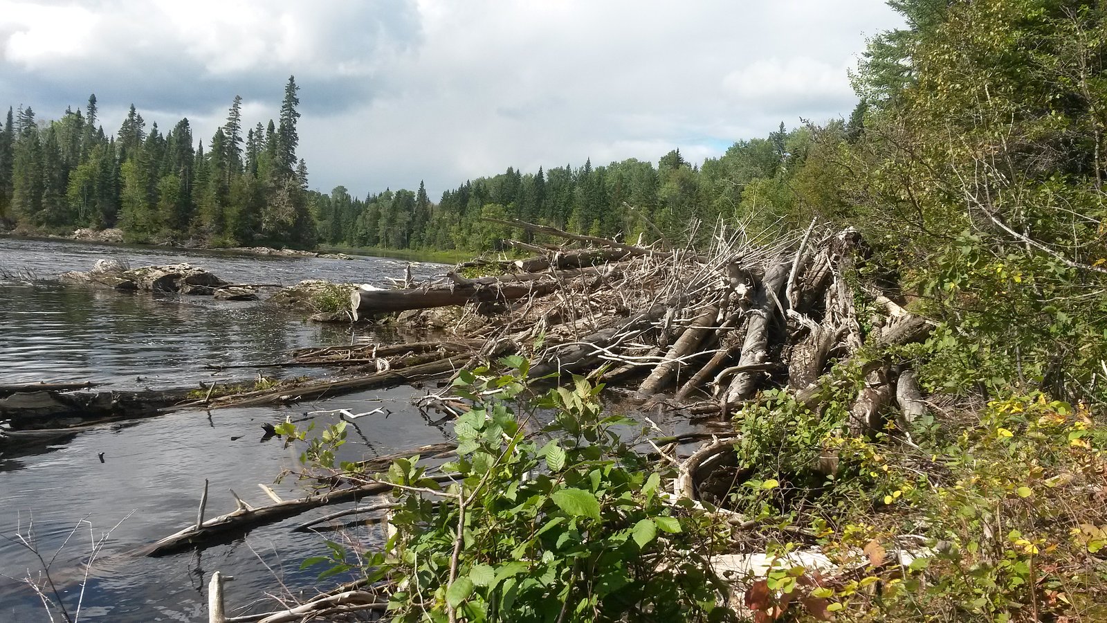
White Otter Falls is a remote northern Ontario waterfall located at approximately 49.2196, -82.688, roughly 20–65 miles from the nearest larger towns (Kapuskasing and Hearst). It is set in boreal forest and is known for a substantial single drop and scenic rugged surroundings. Access is typically into backcountry terrain and may require travel on unmaintained roads, canoe/river travel, floatplane, or extended hiking. Specific on-site facilities are minimal or nonexistent. Exact height and some access details are not confirmed and may vary by source.
Why This Waterfall Exists
White Otter Falls flows over hard intrusive rock, primarily granodiorite and tonalite, laid down over 2.5-3.2 billion years ago. These resistant rocks form a durable ledge that water cannot easily wear away, creating the falls where softer material downstream has already eroded.
Trail & Hike Details
Trail Description
Approaches to White Otter Falls are typically into remote, undeveloped terrain. Trails, if present, may be unmarked, rough, and include wet or boggy sections and river travel. Some reports for remote Ontario falls indicate travel by canoe/portage or logging road + bushwhack; specific trail routing and distance for this location are not confidently confirmed. Hikers should be prepared for route finding and variable conditions.
What to Expect
Boreal forest setting, moss-covered rock, a prominent waterfall with splash pools and cliffs. Spring melt and heavy rain produce the highest flows; late summer may reduce flow. No visitor services on site, no toilets, potable water, or signage expected. Wildlife common to northern Ontario (moose, black bear, beavers, migratory birds). Bugs (black flies, mosquitoes) can be heavy in late spring and summer.
Accessibility
The trail involves steep, uneven terrain with significant elevation change and is not accessible to mobility devices.
Frequently Asked Questions
🐶 Are Dogs Allowed at White Otter Falls?
❌ Dogs are not allowed
Are There Any Fees or Permits Required?
🆖 No fees required
🏊 Is There Swimming at White Otter Falls?
❌ Swimming is not allowed
When to Visit
Spring (high flows and dramatic water volume) or early fall (lower bugs and fall colors). Summer offers easier travel conditions but flow may be reduced. Winter access may be possible for experienced winter travelers (snowmobile/ski/snowshoe) but is often more hazardous.
Seasonal Access
The best time to visit is Spring, Summer, and Fall. Winter access may be limited. Check with the managing park or local authority for current conditions.
Safety Information
Remote location means longer emergency response times. Hazards include slippery and unstable rock near the falls, strong currents, cold water, steep banks, insects, and changing weather. Check river conditions and resource road status before travel. Carry emergency communications and a plan for evacuation. If unsure of route or conditions, consider hiring a local guide.
Current Water Conditions
Based on a Water Survey of Canada gauge 28.2 km away
31.7 m³/s
Current discharge — how much water is flowing
About average for this time of year
Based on 93 years of record
4.65 m
Water depth at gauge
7-Day Discharge Trend
What does this mean for your visit?
Flow is about average for this time of year.
About This Gauge
This gauge is on a regional waterway. Conditions at the falls may differ, especially after local rain.
7-Day Flow Outlook
Based on the WSC gauge KAPUSKASING RIVER AT KAPUSKASING (28 km away).
Today
Moderate
32 m³/s
6/10Tomorrow
Moderate
33 m³/s
5/10Tue
Moderate
35 m³/s
5/10Wed
Moderate
33 m³/s
5/10Thu
Moderate
32 m³/s
5/10Fri
Moderate
31 m³/s
5/10Sat
Moderate
28 m³/s
6/10Best window: Today — moderate flow, cloudy (trip score 6/10).
Best time of year: this gauge typically runs highest from mid April to mid July, peaking in May.
How we calculate this
This is a transparent outlook, not a precise forecast. We take the waterfall's current flow strength (how it ranks against its historical normal for today, from the nearest WSC stream gauge), carry that ranking forward along the gauge's seasonal curve, and nudge it for forecast rain. Confidence is highest for the next day or two and falls further out. Always check official conditions and your own judgment before visiting — high flows can be dangerous.
Know when to go.
Get a free email alert when waterfalls near Kapuskasing hit peak flow. We only send when conditions are worth the trip — no weekly newsletters, no spam.
Weather Forecast
Location & Access
Getting There
Nearest service towns: Kapuskasing (about 20.4 miles) and Hearst (about 64.9 miles). The falls are in a remote area of northern Ontario (coordinates 49.2196, -82.688). Expect unpaved logging or secondary roads, seasonal closures, and likely sections requiring off-road travel, canoe/river approach, or aircraft access. Cell service is likely unreliable; use topographic maps, GPS, or local guide information. Confirm access with local forest/park offices or resource roads operators before travel.
Get Directions on Google MapsParking
Parking and trailhead facilities are likely primitive or nonexistent. If there is a roadside pullout it may be unmarked and not maintained. Park only where legal and safe; avoid blocking gates or resource roads.
Elevation
239 metres above sea level
Coordinates
49.219613° N, -82.687989° W
Visitor Tips & Gear
1) Tell someone your route and expected return time; remote rescues can be delayed. 2) Carry map, compass and GPS; don’t rely on cell coverage. 3) Wear sturdy waterproof footwear and bring insect protection. 4) Be cautious on wet, slippery rocks near the falls and stay back from edges. 5) Check local resource road conditions and permissions (some roads may be private or gated). 6) Pack out everything you bring; no facilities for waste disposal.
Where to Stay
Browse vacation cabins and private rentals nearby
Unique outdoor stays — tents, yurts, and treehouses
Rent a campervan or RV for your waterfall road trip
Some links are affiliate links. We may earn a commission at no extra cost to you.
Additional Information
Nearby Attractions
Services and lodging in Kapuskasing and Hearst. The surrounding region offers typical northern Ontario outdoor activities (fishing, canoeing, hunting, wildlife viewing). Specific nearby park names or maintained trail systems are not confirmed for this exact coordinate.
Wildlife
Typical boreal species: moose, black bear, white-tailed deer, beaver, wolves (rare), lynx (rare), and many songbird and waterfowl species. Take standard wildlife precautions.
Cities near White Otter Falls
Nearby Waterfalls
Writing about White Otter Falls? Embed this waterfall on your site for free.