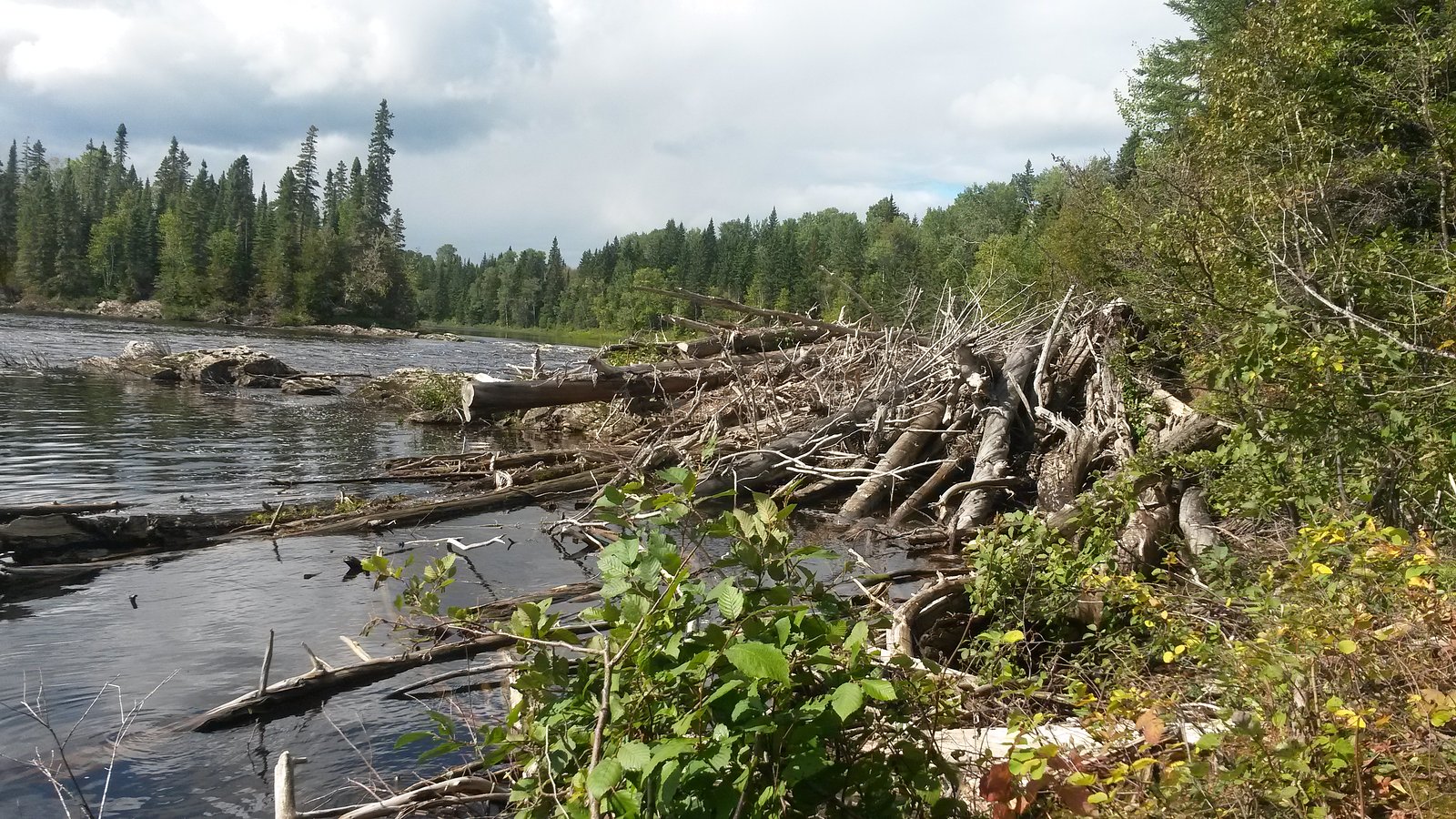
About Big Beaver Falls
Big Beaver Falls (coordinates 49.2993, -82.5284) is a remote cascade on a Big Beaver drainage near Kapuskasing, Ontario (approximately 9.8 miles / ~16 km from Kapuskasing by road). This waterfall appears to be a natural, forested cascade rather than a developed tourist site. Flow is typically highest in spring snowmelt and after heavy rain; in winter the falls may be partially or fully frozen. There is limited official infrastructure or signage at the site and access may require travel on forestry or gravel roads and a short off-trail approach or scramble to the riverbank. Information below is conservative where specific local trail details are not confirmed.
Why This Waterfall Exists
Big Beaver Falls flows over hard intrusive rock, primarily granodiorite and tonalite, laid down over 2.5-3.2 billion years ago. These resistant rocks form a durable ledge that water cannot easily wear away, creating the falls where softer material downstream has already eroded.
Trail & Hike Details
Trail Description
There does not appear to be a developed, maintained trail to the falls. Access likely involves walking from a forestry road pullout along a game trail or cross-country through mixed boreal forest to the riverbank, possibly including a short scramble down to the water. Expect uneven ground, roots, muskeg or wet sections and damp, rocky approaches near the falls. Use caution on banks and wet rock near cascades.
What to Expect
A natural, relatively small cascade set in boreal forest. Expect native forest (spruce, pine, birch), typical northern Ontario undergrowth, and a rocky river corridor. Flow varies by season, peak in spring and after heavy rain; reduced flow in late summer dry periods; ice formations in winter. Little to no visitor infrastructure (no boardwalks, restrooms, or official viewpoints). Cell service may be unreliable.
Accessibility
Site is likely not accessible for visitors with limited mobility. Expect uneven, unmaintained terrain, steep or slippery approaches and no constructed access features.
Frequently Asked Questions
🐶 Are Dogs Allowed at Big Beaver Falls?
❌ Dogs are not allowed
Are There Any Fees or Permits Required?
🆖 No fees required
🏊 Is There Swimming at Big Beaver Falls?
❌ Swimming is not allowed
When to Visit
Late spring (snowmelt) for highest flows and strong visuals; early summer for easier access once roads dry; fall for foliage color and cooler temperatures. Winter can offer dramatic ice formations but requires winter travel skills and equipment and awareness of icy/unstable banks.
Seasonal Access
The best time to visit is Spring, Summer, Fall, and Winter. Check with the managing park or local authority for current conditions.
Safety Information
Hazards include slippery rocks and steep banks near the falls, cold and fast-moving water, changing flow conditions, remoteness and limited cell coverage, insects (black flies, mosquitoes) in warm months, ticks and potential wildlife encounters. Forestry roads may be rough, gated or closed; avoid travel at night and inform someone of your route and expected return. Check local conditions and land ownership before visiting.
Current Water Conditions
31.3 m³/s
Current discharge — how much water is flowing
About average for this time of year
Based on 93 years of record
4.64 m
Water depth at gauge
7-Day Discharge Trend
What does this mean for your visit?
Flow is about average for this time of year.
About This Gauge
This gauge is on a nearby waterway and may not reflect exact conditions at the falls.
7-Day Flow Outlook
Based on the WSC gauge KAPUSKASING RIVER AT KAPUSKASING (14 km away).
Today
Moderate
31 m³/s
6/10Tomorrow
Moderate
33 m³/s
5/10Tue
Moderate
34 m³/s
5/10Wed
Moderate
32 m³/s
5/10Thu
Moderate
33 m³/s
4/10Fri
Moderate
29 m³/s
8/10Sat
Moderate
28 m³/s
5/10Best window: Fri — moderate flow, mainly sunny (trip score 8/10).
Best time of year: this gauge typically runs highest from mid April to mid July, peaking in May.
How we calculate this
This is a transparent outlook, not a precise forecast. We take the waterfall's current flow strength (how it ranks against its historical normal for today, from the nearest WSC stream gauge), carry that ranking forward along the gauge's seasonal curve, and nudge it for forecast rain. Confidence is highest for the next day or two and falls further out. Always check official conditions and your own judgment before visiting — high flows can be dangerous.
Know when to go.
Get a free email alert when waterfalls near Kapuskasing hit peak flow. We only send when conditions are worth the trip — no weekly newsletters, no spam.
Weather Forecast
Location & Access
Getting There
From Kapuskasing drive approximately 9–12 miles (route distance varies with exact approach) on regional/forestry roads toward the Big Beaver watershed. The provided coordinates (49.2993, -82.5284) give the approximate location; expect travel on gravel or seasonal logging roads and limited or no signage. Confirm current road conditions and land access before travelling.
Get Directions on Google MapsParking
No formal parking lot is known. Visitors should plan to park safely on a wide shoulder or at an informal pullout off the forestry or gravel road. Avoid blocking gates or private access roads. Parking may be muddy or uneven.
Elevation
221 metres above sea level
Coordinates
49.299309° N, -82.528442° W
Visitor Tips & Gear
1) Confirm land access and road conditions before you go, forestry roads can be closed for logging or impassable after rain. 2) Wear sturdy, waterproof boots and insect protection in warm months. 3) Bring a map, compass or GPS and download offline maps; coordinates are 49.2993, -82.5284. 4) Do not assume maintained trails or overlooks, use caution near cliff edges and wet rock. 5) Practice Leave No Trace; pack out what you pack in. 6) If you encounter private property or active logging operations, do not trespass and turn back.
Where to Stay
Browse vacation cabins and private rentals nearby
Unique outdoor stays — tents, yurts, and treehouses
Rent a campervan or RV for your waterfall road trip
Some links are affiliate links. We may earn a commission at no extra cost to you.
Additional Information
Nearby Attractions
Town of Kapuskasing (services and information), local rivers and lakes in the region used for fishing and boating. For specific nearby parks or maintained hiking areas, check with local tourism or the Ontario provincial park system.
Wildlife
Typical northern Ontario wildlife may include moose, white-tailed deer, black bear, beaver, and a variety of birds and small mammals. Take standard wildlife precautions and store food securely.
Cities near Big Beaver Falls
Nearby Waterfalls
Writing about Big Beaver Falls? Embed this waterfall on your site for free.