Upper Skookum Falls
British Columbia • 10 m
By Armen Suny · Last verified Jun 2026
About Upper Skookum Falls
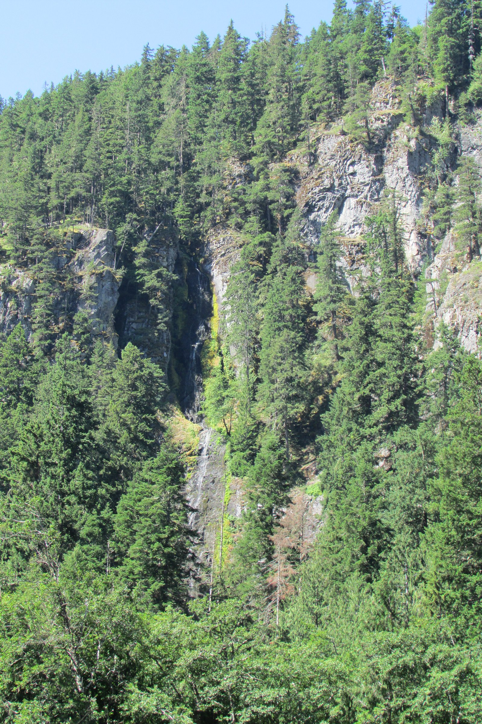
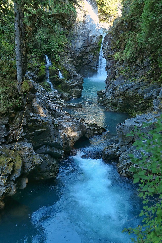
Upper Skookum Falls is a forested, relatively remote waterfall site in the Fraser Valley region of southwestern British Columbia. The falls are reached via unpaved/forest roads and short, often unmaintained footpaths that drop into a narrow creek canyon. Flow and appearance vary seasonally, highest in spring runoff and after heavy rains, lower in late summer. Facilities are minimal or nonexistent and access may require some off-trail scrambling. Exact site features may differ between visitor reports; check recent trail reports before visiting.
The Setting
Upper Skookum Falls sits at 553 metres in the hills of British Columbia. The falls drop 10 metres.
Why This Waterfall Exists
Upper Skookum Falls flows over hard volcanic rock laid down about 101-145 million years ago. These resistant rocks form a durable ledge that water cannot easily wear away, creating a 32-foot drop where softer material downstream has already eroded.
Nearby Falls Worth Visiting
Skookum Falls (20 m) lies 0.6 kilometres to the west. Also nearby: Mamquam Falls (19 m, 7.6 km).
Trail & Hike Details
Trail Description
Approach usually follows a short, informal path from a roadside pullout down into a narrow creek corridor. Trails may be steep, rooty, and poorly maintained; some route-finding and scrambling over rocks and fallen trees may be required. Expect limited signage and a natural, undeveloped setting. If there are multiple cascades or pools, the "Upper" designation indicates this site is above lower cascades on the same creek, so approaches to higher viewpoints may be steeper.
What to Expect
The falls drop 10 metres over hard volcanic rock.
Accessibility
Access is likely not wheelchair accessible and may be unsuitable for visitors with limited mobility due to unmaintained trails, steep sections, and scrambling. No developed facilities or accessible viewpoints are expected.
Frequently Asked Questions
🐶 Are Dogs Allowed at Upper Skookum Falls?
❌ Dogs are not allowed
Are There Any Fees or Permits Required?
🆖 No fees required
🏊 Is There Swimming at Upper Skookum Falls?
❌ Swimming is not allowed
When to Visit
Spring (late melt/runoff) for highest flows and dramatic water volume; late spring to early summer often offers comfortable hiking conditions. Fall can provide colorful foliage and good water levels after seasonal rains. Winter and periods of heavy rain can make access hazardous due to muddy roads, high water, and ice, use extra caution or avoid if conditions are severe.
Seasonal Access
The best time to visit is Spring, Summer, and Fall. Winter access may be limited. Check with the managing park or local authority for current conditions.
Safety Information
Hazards include slippery rocks and trails, steep drop-offs, variable water flows and strong currents near cascades, unstable banks, and limited or intermittent cell service. Weather can change quickly; roads and trails may become muddy or impassable after heavy rain. Logging activity or private land boundaries may affect access, respect signage and closures. Bring navigation aids and a first-aid kit, and avoid solo trips if unfamiliar with the area.
Current Water Conditions
16.1 m³/s
Current discharge — how much water is flowing
Lower than usual for this time of year
Based on 33 years of record
1.58 m
Water depth at gauge
7-Day Discharge Trend
What does this mean for your visit?
Flow is lower than usual for this time of year.
About This Gauge
This gauge is on a nearby waterway and may not reflect exact conditions at the falls.
7-Day Flow Outlook
Based on the WSC gauge MAMQUAM RIVER ABOVE RING CREEK (8 km away).
Today
Low
16 m³/s
6/10Tomorrow
Low
16 m³/s
5/10Tue
Low
16 m³/s
5/10Wed
Low
17 m³/s
5/10Thu
Low
14 m³/s
5/10Fri
Moderate
17 m³/s
5/10Sat
Moderate
15 m³/s
5/10Best window: Today — low flow, sunny (trip score 6/10).
Best time of year: this gauge typically runs highest from late April to mid July, peaking in June.
How we calculate this
This is a transparent outlook, not a precise forecast. We take the waterfall's current flow strength (how it ranks against its historical normal for today, from the nearest WSC stream gauge), carry that ranking forward along the gauge's seasonal curve, and nudge it for forecast rain. Confidence is highest for the next day or two and falls further out. Always check official conditions and your own judgment before visiting — high flows can be dangerous.
Know when to go.
Get a free email alert when waterfalls near Vancouver hit peak flow. We only send when conditions are worth the trip — no weekly newsletters, no spam.
Weather Forecast
Location & Access
Getting There
Upper Skookum Falls is located in the Fraser Valley / Harrison area (coordinates: 49.7263, -122.9864). The site sits in a forested valley and is typically reached from local secondary or forest service roads branching off the Lougheed Highway (Highway 7) or nearby local roads. Final approach frequently involves driving on unpaved roads and walking on an unmarked or lightly marked footpath/track. Visitors should consult recent trip reports, local forest service maps, or community trail resources before heading out.
Get Directions on Google MapsParking
Parking is typically limited to a roadside pullout or small informal parking area; there are no developed parking lots, restrooms, or visitor services. Park legally and avoid blocking gates or logging entrances. Conditions of roadside parking can change with logging activity or weather.
Elevation
553 metres above sea level
Coordinates
49.726314° N, -122.986422° W
Visitor Tips & Gear
1) Check recent trip reports or local resources before you go, access can change with logging or private land closures. 2) Wear sturdy footwear with good traction; expect wet, muddy and rooty trails. 3) Bring a map/GPS and let someone know your plan, approach routes can be confusing. 4) Pack out everything you bring in; there are no facilities. 5) Avoid cliff edges and slippery rocks near the water; currents can be stronger than they appear. 6) Be prepared for insects in summer and variable weather in shoulder seasons.
Where to Stay
Browse vacation cabins and private rentals nearby
Unique outdoor stays — tents, yurts, and treehouses
Rent a campervan or RV for your waterfall road trip
Some links are affiliate links. We may earn a commission at no extra cost to you.
Nearby Campground
Raffuse Creek Recreation Area
4.5 km away
Additional Information
Nearby Attractions
Harrison Hot Springs and Fraser Valley attractions are in the broader region. Nearby points of interest that are often visited in the same general area include Harrison Hot Springs, Kilby Historic Site, Bridal Veil Falls (in the greater Fraser Valley), and local lakes and hiking areas. Distances and accessibility vary, plan extra time if visiting multiple sites.
Wildlife
Expect typical lower-elevation coastal British Columbia wildlife: deer, small mammals, a variety of birds, and possibly black bears and cougars. Also be aware of ticks in warmer months. Practice standard wildlife awareness: store food securely, keep distance, and know how to respond to encounters.
Cities near Upper Skookum Falls
Nearby Waterfalls

Writing about Upper Skookum Falls? Embed this waterfall on your site for free.