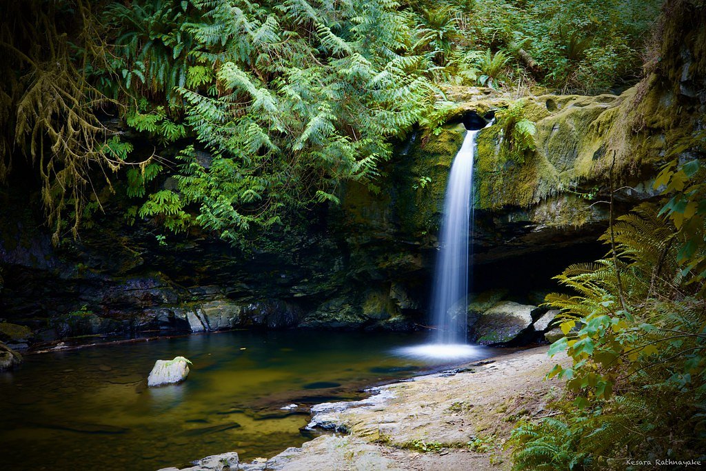
Upper Banon Creek Falls
By Armen Suny · Last verified Jun 2026
Difficulty
Moderate
Trail Length
9.8 km
Trail Type
Out And Back
Elevation Gain
405 m
About Upper Banon Creek Falls
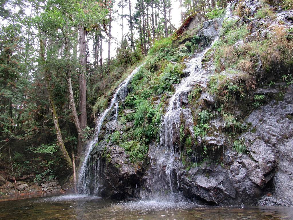
Upper Banon Creek Falls is a small, forested waterfall on southern Vancouver Island near Nanaimo. Coordinates given (48.9438, -123.8303) place it in a wooded creek valley typical of the region: coniferous forest, ferns, and moss-covered rock. Specific published information about the falls is limited; access appears to be via unpaved/forestry roads and short trails or cross-country routes rather than a developed park trail. Water flow is typically highest in spring and after heavy rain.
Why This Waterfall Exists
Upper Banon Creek Falls flows over hard volcanic rock laid down about 252-419 million years ago. These resistant rocks form a durable ledge that water cannot easily wear away, creating the falls where softer material downstream has already eroded.
Nearby Falls Worth Visiting
Stocking Creek Falls (15 m) lies 4.3 kilometres to the east.
Trail & Hike Details
The Approach
The moderate 9.8-km out-and-back trail gains 405 metres of elevation on the way to the falls.
Trail Description
There is little formally published trail information for Upper Banon Creek Falls. Reports for similar small, off-the-beaten-path falls on Vancouver Island indicate routes that are short but can be steep, poorly marked, and may require scrambling or brief bushwhacking to reach the creek and falls. Expect a natural, unmaintained path through second-growth and native forest with roots and uneven footing. Because reliable trail descriptions and distances are not publicly documented, plan for variable conditions and limited signage.
What to Expect
Woodland creek setting with mossy rocks and steep banks near the falls. Seasonal streamflow: highest in spring and after rainfall, lower in late summer. Minimal visitor infrastructure (no viewing platforms, railings, or restrooms). Narrow, possibly muddy trails; slippery rock and steep edges near the water. Limited cell reception is possible in valleys and forested areas.
Accessibility
The trail involves steep, uneven terrain with significant elevation change and is not accessible to mobility devices.
Frequently Asked Questions
🐶 Are Dogs Allowed at Upper Banon Creek Falls?
❌ Dogs are not allowed
Are There Any Fees or Permits Required?
🆖 No fees required
🏊 Is There Swimming at Upper Banon Creek Falls?
❌ Swimming is not allowed
When to Visit
Spring for peak flow and lush green moss; summer for easier access and drier trails; fall for color and lower but still scenic flow. Winter can be wet, muddy, and may reduce safe access, check conditions before attempting a visit.
Seasonal Access
The best time to visit is Spring, Summer, and Fall. Winter access may be limited. Check with the managing park or local authority for current conditions.
Safety Information
Hazards include slippery rocks, fast-flowing water after rain, steep and unstable banks, poor trail markings, limited cell service, and possible active forestry operations. Wear appropriate footwear, stay off wet rocks near the falls, avoid getting too close to edges, and do not attempt to cross swollen creeks. If bears or other large wildlife are known in the area, carry bear spray and know how to use it. Check local forest service or regional district notices for road closures or logging activity.
Current Water Conditions
0.4 m³/s
Current discharge — how much water is flowing
Much lower than usual for this time of year
Based on 75 years of record
0.55 m
Water depth at gauge
7-Day Discharge Trend
What does this mean for your visit?
Flow is well below normal for this time of year, so the waterfall may be a trickle.
About This Gauge
This gauge is on a nearby waterway and may not reflect exact conditions at the falls.
7-Day Flow Outlook
Based on the WSC gauge CHEMAINUS RIVER NEAR WESTHOLME (12 km away).
Today
Barely Flowing
0.4 m³/s
4/10Tomorrow
Barely Flowing
0.4 m³/s
4/10Tue
Barely Flowing
0.4 m³/s
4/10Wed
Barely Flowing
0.3 m³/s
4/10Thu
Barely Flowing
0.3 m³/s
4/10Fri
Barely Flowing
0.3 m³/s
4/10Sat
Barely Flowing
0.3 m³/s
4/10Best window: Today — barely flowing flow, partly cloudy (trip score 4/10).
Best time of year: this gauge typically runs highest from early January to late January, peaking in December.
How we calculate this
This is a transparent outlook, not a precise forecast. We take the waterfall's current flow strength (how it ranks against its historical normal for today, from the nearest WSC stream gauge), carry that ranking forward along the gauge's seasonal curve, and nudge it for forecast rain. Confidence is highest for the next day or two and falls further out. Always check official conditions and your own judgment before visiting — high flows can be dangerous.
Know when to go.
Get a free email alert when waterfalls near Nanaimo hit peak flow. We only send when conditions are worth the trip — no weekly newsletters, no spam.
Weather Forecast
Location & Access
Getting There
Located on southern Vancouver Island near Nanaimo (approximately 13.7 miles away), Point Roberts (approx. 34.9 miles), and Vancouver (approx. 44.5 miles). Coordinates: 48.9438, -123.8303. Access likely requires driving on secondary or forest/industrial roads followed by an unsigned or lightly signed forest trail; exact public access points and parking are not well documented. Visitors should consult local maps, the regional district, or local hiking resources before travelling.
Get Directions on Google MapsParking
Parking is likely informal (roadside pullouts or small gravel parking areas). Expect limited or no marked parking, no formal facilities, and possible private/industrial access restrictions near logging roads. Park legally and avoid blocking gates or driveways.
Elevation
535 metres above sea level
Coordinates
48.943753° N, -123.830297° W
Visitor Tips & Gear
1) Use sturdy, grippy footwear and be prepared for muddy or wet conditions. 2) Bring a map and GPS (use the coordinates) and tell someone your plans. 3) Stay back from cliff edges and wet rocks, they are slippery. 4) Respect private property and active forestry operations; obey signs and gates. 5) Pack out all trash and follow Leave No Trace. 6) Check current conditions with local outdoor groups, regional district, or forestry offices before you go.
As an Amazon Associate, we earn from qualifying purchases.
With 9.8 km and 405 m of elevation gain, sturdy boots and trekking poles will help on this moderate trail. Sun exposure on the trail makes good sun protection a must in summer.

Columbia Watertight II Rain Jacket
Packs into its own pocket, seam-sealed, and keeps you dry from spray and surprise rain.

Earth Pak Waterproof Dry Bag
Keeps your phone and gear dry when waterfall mist soaks everything else.

Waterproof Phone Pouch (AiRunTech)
Cheap insurance — take photos right next to the falls without killing your phone.

Timberland Euro Sprint Mid Waterproof
Trusted waterproof boot with premium leather and grippy rubber sole — reliable on rocky, wet trails.

TrailBuddy Trekking Poles
Lightweight aluminum, cork grips, and flip-locks that actually hold — a best-seller for good reason.

Sawyer Squeeze Water Filter
The backcountry standard — filters 99.9% of bacteria and weighs just 3 oz.
Where to Stay
Browse vacation cabins and private rentals nearby
Unique outdoor stays — tents, yurts, and treehouses
Rent a campervan or RV for your waterfall road trip
Some links are affiliate links. We may earn a commission at no extra cost to you.
Nearby Campground
Campers Corner
4 km away
Additional Information
Nearby Attractions
Nanaimo and surrounding coastal parks and recreation areas on southern Vancouver Island. Other regional attractions (depending on route and distance) may include local rivers, viewpoints, and island marine parks near Nanaimo.
Wildlife
Typical coastal Vancouver Island species may be present: black-tailed deer, black bears (occasional), cougars (rare), bald eagles, songbirds, and salmon in some streams. Standard wildlife precautions (store food, give animals space) apply.
Cities near Upper Banon Creek Falls
Nearby Waterfalls

Writing about Upper Banon Creek Falls? Embed this waterfall on your site for free.