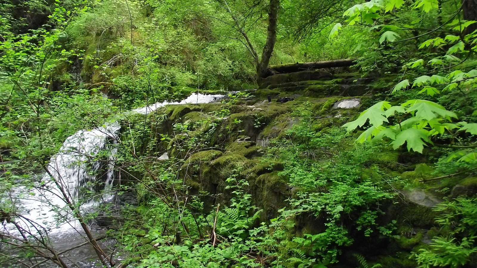
Triple Falls
By Armen Suny · Last verified Jun 2026
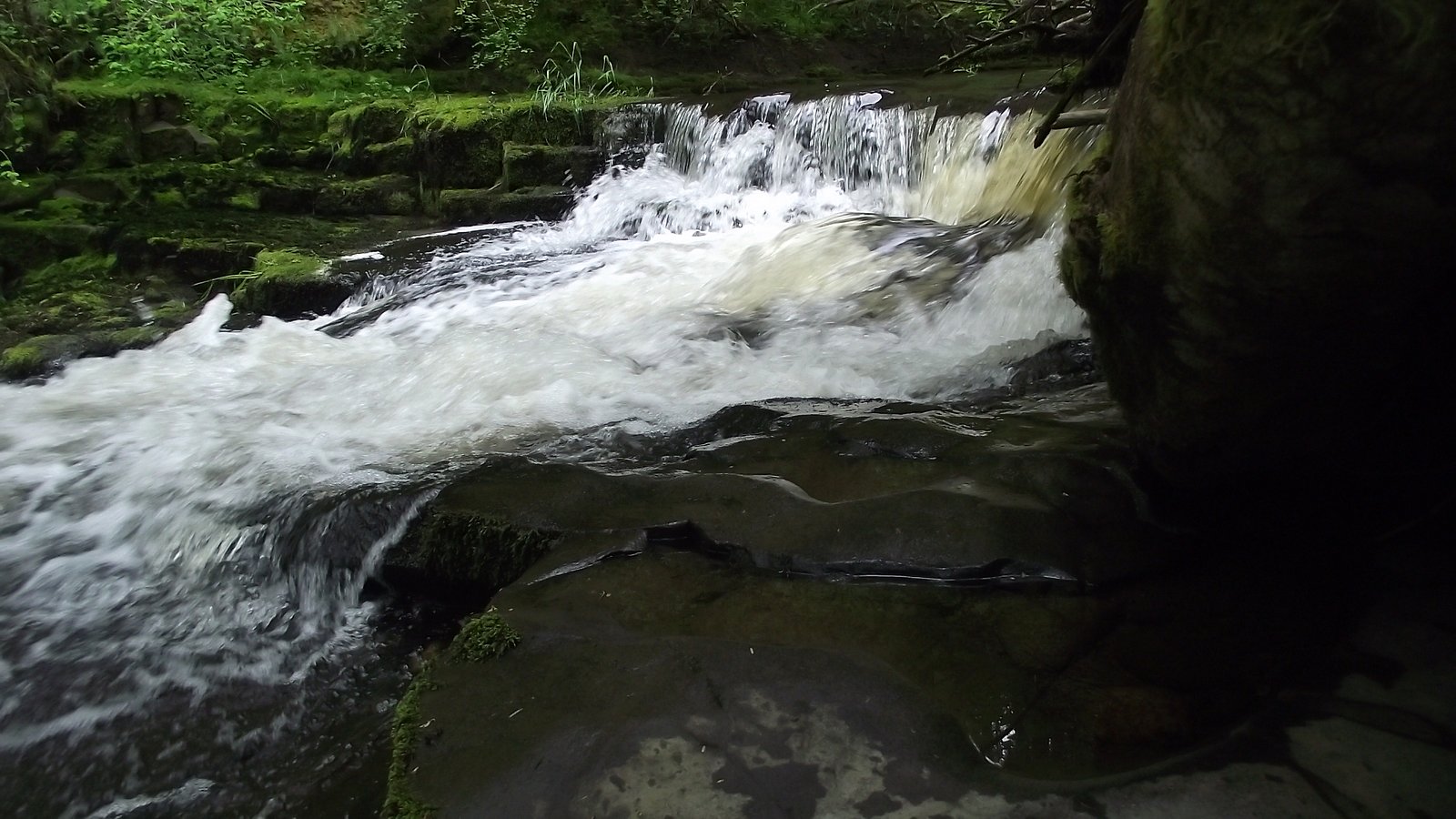
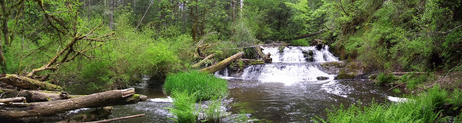
Photo Credits (4)
Difficulty
Easy
Trail Length
1.1 km
Trail Type
Out And Back
Elevation Gain
22 m
About Triple Falls
Triple Falls is a multi-tiered waterfall located on Vancouver Island in British Columbia, roughly southwest of Nanaimo (coordinates approximately 49.2788, -124.3285). The falls are described in local reports as a series of cascades or tiers that create a visually striking set of drops through coastal temperate rainforest. Specifics about official park boundaries, managed trailhead names, and the exact measured height are not clearly documented in major trail databases available to me; details below err on the side of caution and include uncertainty where appropriate.
The Setting
Triple Falls sits at 105 metres within PARKSVILLE-QUALICUM BEACH WILDLIFE MANAGEMENT AREA, in the coastal lowlands of British Columbia.
Why This Waterfall Exists
Triple Falls flows over Nanaimo Group, a layered sedimentary rock layer deposited about 66-101 million years ago. Over time, the stream has worn through these layers at different rates, creating the step that forms the waterfall.
Nearby Falls Worth Visiting
Englishman River Upper Falls (24 m) lies 4.2 kilometres to the southwest. Also nearby: Englishman River Falls (24 m, 4.2 km) and Knarston Waterfall (12 m, 15.6 km).
Trail & Hike Details
The Approach
The easy 1.1-km out-and-back trail gains 22 metres of elevation on the way to the falls.
Trail Description
Reliable, detailed trail descriptions for Triple Falls at these coordinates are limited. Local visitor reports suggest a relatively short approach in forested terrain with uneven, potentially steep or rocky sections near the cascades. Trails may be unmaintained or partially informal (use of boot paths), and approaches could include short scrambles to multiple viewing points. Conditions can change quickly with seasonal weather and logging activity; confirm current trail status with local authorities or recent visitor reports before setting out.
What to Expect
Expect a coastal temperate rainforest setting: dense evergreen trees, ferns, moss, and wet, slippery rock surfaces. Water flow will vary seasonally, typically highest in late fall through spring after rain and snowmelt, and lower in late summer. There may be several cascades or tiers, hence the name 'Triple Falls.' Facilities (toilets, potable water, maintained viewpoints) are unlikely unless the falls are inside a formally managed park; assume minimal infrastructure.
Accessibility
The trail is short and relatively flat, but the surface may be uneven. Contact the managing agency for accessibility details.
Frequently Asked Questions
🐶 Are Dogs Allowed at Triple Falls?
❌ Dogs are not allowed
Are There Any Fees or Permits Required?
🆖 No fees required
🏊 Is There Swimming at Triple Falls?
❌ Swimming is not allowed
When to Visit
Late fall through spring (after rain and during snowmelt) generally produces the most impressive flows. Late spring and early summer may offer pleasant hiking conditions with full flows and greener surroundings. Summer can be drier and reduce flow; winter visits may be icy and slippery, exercise extra caution.
Seasonal Access
The best time to visit is Spring, Summer, Fall, and Winter. Check with the managing park or local authority for current conditions.
Safety Information
• Trails and rocks near waterfalls are frequently slippery; wear appropriate footwear and avoid getting too close to the edge. • Watch for loose rock, sudden drop-offs, and unstable banks. • River currents and undercut ledges can be deadly; never underestimate water strength. • Weather on Vancouver Island can change quickly, bring rain protection and warm layers. • Mobile phone reception may be unreliable; tell someone your route and expected return time. • Be cautious of seasonal hazards such as high flows in spring, icy sections in winter, and active logging roads.
Current Water Conditions
0.9 m³/s
Current discharge — how much water is flowing
Much lower than usual for this time of year
Based on 53 years of record
0.89 m
Water depth at gauge
7-Day Discharge Trend
What does this mean for your visit?
Flow is well below normal for this time of year, so the waterfall may be a trickle.
About This Gauge
7-Day Flow Outlook
Based on the WSC gauge ENGLISHMAN RIVER NEAR PARKSVILLE (5 km away).
Today
Barely Flowing
0.9 m³/s
4/10Tomorrow
Barely Flowing
0.9 m³/s
4/10Tue
Barely Flowing
0.8 m³/s
4/10Wed
Barely Flowing
0.8 m³/s
4/10Thu
Barely Flowing
0.8 m³/s
4/10Fri
Barely Flowing
0.8 m³/s
4/10Sat
Barely Flowing
0.8 m³/s
4/10Best window: Today — barely flowing flow, cloudy (trip score 4/10).
Best time of year: this gauge typically runs highest from early January to mid February, peaking in January.
How we calculate this
This is a transparent outlook, not a precise forecast. We take the waterfall's current flow strength (how it ranks against its historical normal for today, from the nearest WSC stream gauge), carry that ranking forward along the gauge's seasonal curve, and nudge it for forecast rain. Confidence is highest for the next day or two and falls further out. Always check official conditions and your own judgment before visiting — high flows can be dangerous.
Know when to go.
Get a free email alert when waterfalls near Nanaimo hit peak flow. We only send when conditions are worth the trip — no weekly newsletters, no spam.
Weather Forecast
Location & Access
Getting There
The falls are located on central Vancouver Island near the provided coordinates and are generally reached by driving from Nanaimo or other nearby towns, then following local access roads and a short hiking approach. Exact directions, road names, and GPS-accessible trailheads are not consistently documented in public trail databases; visitors should consult local maps or park/forest service information and verify access before travel.
Get Directions on Google MapsParking
Parking information is not consistently documented. Expect limited or informal roadside parking at or near the trail access; some approaches may use unpaved forest service/forestry roads with small pullouts. Park only where permitted and avoid blocking gates or private driveways.
Elevation
105 metres above sea level
Coordinates
49.278778° N, -124.328513° W
Land Management
Managed by Government of British Columbia
Visitor Tips & Gear
• Wear sturdy, waterproof footwear with good traction; rocks and roots near the falls are often slippery. • Use caution when approaching the water or cliff edges, wet rocks and vegetation hide drop-offs. • Check recent trip reports or contact local visitor centres (e.g., Nanaimo area) for up-to-date access and parking info. • Carry insect repellent in spring/summer and be prepared for muddy trail conditions after rain. • Pack out all garbage; facilities are likely limited or absent. • If you plan to use forest service roads, check for seasonal closures or gates and respect private property.
As an Amazon Associate, we earn from qualifying purchases.
For this easy 1.1 km trail, lightweight trail shoes and a water bottle are usually sufficient. Icy conditions are common in winter — traction cleats are a smart addition.

Columbia Watertight II Rain Jacket
Packs into its own pocket, seam-sealed, and keeps you dry from spray and surprise rain.

Polarized Sunglasses (Knockaround)
Cuts glare off the water so you actually see the falls — and your photos turn out better too.

Earth Pak Waterproof Dry Bag
Keeps your phone and gear dry when waterfall mist soaks everything else.

Waterproof Phone Pouch (AiRunTech)
Cheap insurance — take photos right next to the falls without killing your phone.

Kahtoola MICROspikes
Cult-favorite traction cleats that grip ice and wet rock — essential for winter waterfall hikes.

JOBY GorillaPod Starter Kit
Wraps around railings and rocks for long-exposure waterfall shots — no flat surface needed.
Where to Stay
Browse vacation cabins and private rentals nearby
Unique outdoor stays — tents, yurts, and treehouses
Rent a campervan or RV for your waterfall road trip
Some links are affiliate links. We may earn a commission at no extra cost to you.
Nearby Campground
Pathfinder Camp Resorts - Parksville
5 km away
Additional Information
Nearby Attractions
Nanaimo attractions (Harbour, Newcastle Island Marine Provincial Park), Englishman River Falls Provincial Park, Little Qualicum Falls Provincial Park, and other coastal and forest recreation areas on central Vancouver Island. Exact proximity depends on the specific access route to Triple Falls.
Wildlife
Typical coastal Vancouver Island wildlife may be present: black bears, cougars (remnants), black-tailed deer, birds such as bald eagles and various songbirds, and salmon in nearby streams in season. Practice standard wildlife safety: store food securely, make noise on the trail, and keep distance from animals.
Cities near Triple Falls
Nearby Waterfalls

Other waterfalls named Triple Falls
4 other waterfalls share this name across Canada.
Writing about Triple Falls? Embed this waterfall on your site for free.