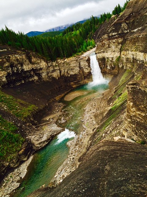
Tapestry Falls
Alberta • 25 m
By Armen Suny · Last verified Jun 2026
About Tapestry Falls
Tapestry Falls is a lesser-known mountain stream waterfall located in the eastern slopes of the Canadian Rockies in Alberta (coordinates: 52.1628, -115.7468). It appears to sit in a remote, wooded alpine/subalpine setting and is likely fed by seasonal snowmelt and mountain tributaries. There is limited published information from major park sources and trail guides, so many specifics (exact height, developed trail infrastructure) are not well documented and may vary by year.
The Setting
Tapestry Falls sits at 1,461 metres in the mountains of Alberta. The falls drop 25 metres.
Why This Waterfall Exists
Tapestry Falls flows over Alberta Group; Smoky Group, a layered sedimentary rock layer deposited about 66-101 million years ago. These soft rocks erode readily, allowing the stream to carve a 82-foot drop into the landscape.
Nearby Falls Worth Visiting
Ram Falls (29 m) lies 10.3 kilometres to the southwest. Also nearby: Table Rock Falls (11 m, 1.1 km).
Trail & Hike Details
Trail Description
There is no widely published, maintained trail description for Tapestry Falls from major trail services. Approaches may be unmarked or follow game/creek routes and can involve uneven terrain, bushwhacking, and stream crossings. Trail conditions and length likely vary by chosen approach and starting point.
What to Expect
The falls cascade 25 metres over soft layered mudrock.
Accessibility
The site is likely not wheelchair accessible. Expect rough, uneven, and potentially steep terrain; mobility-limited visitors may not be able to reach the falls safely.
Frequently Asked Questions
🐶 Are Dogs Allowed at Tapestry Falls?
❌ Dogs are not allowed
Are There Any Fees or Permits Required?
🆖 No fees required
🏊 Is There Swimming at Tapestry Falls?
❌ Swimming is not allowed
When to Visit
Late spring to early summer for highest flow (snowmelt). Early fall may offer lower water levels but good colours and cooler weather. Winter visits are possible but may require snow travel skills; ice and avalanche hazards may be present.
Seasonal Access
The best time to visit is Spring, Summer, and Fall. Winter access may be limited. Check with the managing park or local authority for current conditions.
Safety Information
Hazards may include steep, slippery rocks and riverbanks, cold water and strong currents (especially during snowmelt), sudden weather changes, falling rocks or tree debris, limited or no cell service, and wildlife encounters. In winter and shoulder seasons, expect snow, ice, and potential avalanche risk in steep terrain. Use caution near cliff edges and avoid getting too close to the falls or fast-moving water. Bring navigation tools and emergency supplies and err on the side of caution if conditions are uncertain.
Current Water Conditions
3.0 m³/s
Current discharge — how much water is flowing
About average for this time of year
Based on 50 years of record
0.93 m
Water depth at gauge
7-Day Discharge Trend
What does this mean for your visit?
Flow is about average for this time of year.
About This Gauge
This gauge is on a nearby waterway and may not reflect exact conditions at the falls.
7-Day Flow Outlook
Based on the WSC gauge NORTH RAM RIVER AT FORESTRY ROAD (22 km away).
Today
Moderate
3.3 m³/s
5/10Tomorrow
Moderate
3.3 m³/s
5/10Tue
Moderate
3.1 m³/s
5/10Wed
Moderate
2.8 m³/s
8/10Thu
Moderate
2.9 m³/s
5/10Fri
Moderate
2.9 m³/s
5/10Sat
Moderate
2.5 m³/s
8/10Best window: Wed — moderate flow, mainly sunny (trip score 8/10).
Best time of year: this gauge typically runs highest from early June to mid July, peaking in June.
How we calculate this
This is a transparent outlook, not a precise forecast. We take the waterfall's current flow strength (how it ranks against its historical normal for today, from the nearest WSC stream gauge), carry that ranking forward along the gauge's seasonal curve, and nudge it for forecast rain. Confidence is highest for the next day or two and falls further out. Always check official conditions and your own judgment before visiting — high flows can be dangerous.
Weather Forecast
Location & Access
Getting There
The falls are at the provided coordinates in a remote area of Alberta's mountain foothills. Access is likely via secondary or forest service roads followed by a hike; exact approach routes are not well documented in major public trail databases. Visitors should consult detailed topographic maps, local land managers (Alberta Parks, municipal/forest authorities), or recent trip reports before traveling.
Get Directions on Google MapsParking
Formal parking information is not available. Expect limited or informal roadside pullouts or small parking areas near trailheads; avoid blocking gates or driveways and use established pullouts where present.
Elevation
1,461 metres above sea level
Coordinates
52.162778° N, -115.746846° W
Visitor Tips & Gear
1) Confirm land ownership and access before you go (provincial public land vs. private). 2) Use a GPS device or topographic map with the provided coordinates. 3) Wear sturdy, waterproof footwear and be prepared for wet, uneven terrain. 4) Tell someone your route and expected return time; solo travel in remote areas raises risk. 5) Carry bear safety equipment and know how to use it. 6) Leave no trace and avoid disturbing fragile vegetation or riverbanks.
Where to Stay
Browse vacation cabins and private rentals nearby
Unique outdoor stays — tents, yurts, and treehouses
Rent a campervan or RV for your waterfall road trip
Some links are affiliate links. We may earn a commission at no extra cost to you.
Nearby Campground
Ram River Falls Provincial Campground
10.4 km away
Additional Information
Nearby Attractions
This area is within the broader Alberta Rockies region; there may be other trails, viewpoints, and alpine attractions in the general region. Visitors should consult regional guidebooks or provincial park information for confirmed nearby destinations.
Wildlife
Potential wildlife includes black and grizzly bears, elk, deer, moose, wolves, and small mammals. Birdlife and amphibians may be present near streams. Always maintain distance and follow wildlife-safety best practices.
Nearby Waterfalls

Writing about Tapestry Falls? Embed this waterfall on your site for free.