
Ram Falls
Alberta • 29 m
By Armen Suny · Last verified Jun 2026
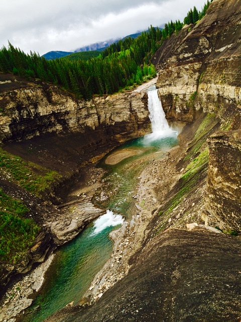
Photo Credits (2)
Difficulty
Easy
Trail Length
0.8 km
Trail Type
Out And Back
Elevation Gain
18 m
About Ram Falls
Ram Falls is a scenic waterfall on the Ram River in west‑central Alberta. It drops through a rocky, often steep canyon and is set in a remote, rugged landscape. The site is popular with hikers, photographers, and visitors seeking a quieter, more off‑the‑beaten‑path waterfall experience. Exact height measurements are not consistently reported; conditions and water volume vary seasonally.
The Setting
Ram Falls sits at 1,610 metres within Ram Falls Provincial Park, in the high mountains of Alberta. The falls drop 29 metres.
Why This Waterfall Exists
Ram Falls flows over Alberta Group; Smoky Group, a layered sedimentary rock layer deposited about 66-101 million years ago. These soft rocks erode readily, allowing the stream to carve a 95-foot drop into the landscape.
Nearby Falls Worth Visiting
Tapestry Falls (25 m) lies 10.3 kilometres to the northeast. Also nearby: Table Rock Falls (11 m, 10.6 km).
Trail & Hike Details
The Approach
The easy 0.8-km out-and-back trail gains 18 metres of elevation on the way to the falls.
Trail Description
Approach to Ram Falls generally involves a short to moderate walk from an informal parking area to viewpoints above the falls and along the canyon rim. Trails may be singletrack, uneven, and can include rocky or muddy sections. There may be no formal boardwalks, guardrails or maintained viewing platforms; some visitors scramble closer to the water or down to the riverbank where safe. Trail signage and maintenance levels can vary; follow obvious game/visitor paths if a formal trail is not present.
What to Expect
The falls cascade 29 metres over soft layered mudrock.
Accessibility
The trail is short and relatively flat, but the surface may be uneven. Contact the managing agency for accessibility details.
Frequently Asked Questions
🐶 Are Dogs Allowed at Ram Falls?
❌ Dogs are not allowed
Are There Any Fees or Permits Required?
🆖 No fees required
🏊 Is There Swimming at Ram Falls?
❌ Swimming is not allowed
When to Visit
Late spring to early summer for higher flows and dramatic water; summer and early fall for more reliable road access and milder weather. Avoid winter unless experienced in winter backcountry travel, roads and trails can be snowed in and icy.
Seasonal Access
The best time to visit is Spring, Summer, and Fall. Access roads and trails may close during winter due to snow. Check with the managing park or local authority for current conditions.
Safety Information
Hazards include slippery and unstable rock near the canyon rim, steep drop‑offs, rapidly changing water levels (especially during spring melt), remote location with limited cell service, and variable road conditions. Do not approach cliff edges, supervise children closely, and avoid visiting alone if possible. In winter, avalanche and ice hazards may exist. Carry emergency supplies and tell someone your route and expected return time.
Current Water Conditions
Based on a Water Survey of Canada gauge 24.3 km away
3.0 m³/s
Current discharge — how much water is flowing
About average for this time of year
Based on 50 years of record
0.93 m
Water depth at gauge
7-Day Discharge Trend
What does this mean for your visit?
Flow is about average for this time of year.
About This Gauge
This gauge is on a regional waterway. Conditions at the falls may differ, especially after local rain.
7-Day Flow Outlook
Based on the WSC gauge NORTH RAM RIVER AT FORESTRY ROAD (24 km away).
Today
Moderate
3.3 m³/s
5/10Tomorrow
Moderate
3.3 m³/s
5/10Tue
Moderate
3.2 m³/s
6/10Wed
Moderate
3.0 m³/s
5/10Thu
Moderate
2.8 m³/s
6/10Fri
Moderate
2.8 m³/s
5/10Sat
Moderate
2.5 m³/s
8/10Best window: Sat — moderate flow, sunny (trip score 8/10).
Best time of year: this gauge typically runs highest from early June to mid July, peaking in June.
How we calculate this
This is a transparent outlook, not a precise forecast. We take the waterfall's current flow strength (how it ranks against its historical normal for today, from the nearest WSC stream gauge), carry that ranking forward along the gauge's seasonal curve, and nudge it for forecast rain. Confidence is highest for the next day or two and falls further out. Always check official conditions and your own judgment before visiting — high flows can be dangerous.
Know when to go.
Get a free email alert when waterfalls near Lake Louise hit peak flow. We only send when conditions are worth the trip — no weekly newsletters, no spam.
Weather Forecast
Location & Access
Getting There
Located at approximately 52.0884, -115.8386. Access typically requires driving on a combination of paved highways and secondary gravel/forest roads; a high‑clearance vehicle is often recommended. The trailhead/parking area is reached from regional roads (the area is remote, expect long driving distances from major centres such as Lake Louise). Cell service may be limited.
Get Directions on Google MapsParking
There is usually a small, informal parking area near the trailhead. Parking may be unmarked and limited; park considerately to avoid blocking access roads. In busy times or in winter these areas can fill quickly or be snow‑covered.
Elevation
1,610 metres above sea level
Coordinates
52.088376° N, -115.838618° W
Land Management
Managed by Parks Division, Alberta Forestry and Parks
Visitor Tips & Gear
- Use a high‑clearance vehicle if venturing on gravel/forest roads and check local road reports before travel. - Wear sturdy footwear, rocks and trails can be slippery, especially near the water. - If you plan to scramble closer to the falls, go with a partner and avoid wet, mossy rock. - Leave no trace: pack out all garbage and avoid disturbing vegetation or cliff edges. - Cell service can be unreliable; bring a paper map, GPS coordinates, or offline maps.
This trail sits at 5,282 ft above sea level
Elevated TrailUV radiation is roughly 21% stronger at this elevation than at sea level, and the dry air accelerates dehydration. Extra sun protection and fluids go a long way.
As an Amazon Associate, we earn from qualifying purchases.

Coppertone Sport SPF 50 Sunscreen
UV intensity jumps ~4% per 1,000 ft — at this elevation you can burn in half the time.

Sun Bum SPF 30 Lip Balm (3-Pack)
Lips have almost no natural UV protection and burn fast in thin, dry mountain air.

Liquid I.V. Electrolyte Packets
You lose moisture ~2x faster at elevation — electrolytes help you absorb water efficiently.

ROCKNIGHT Polarized UV400 Sunglasses
High-altitude glare off rock and water is intense — UV400 lenses block 99%+ of UVA/UVB.
As an Amazon Associate, we earn from qualifying purchases.
For this easy 0.8 km trail, lightweight trail shoes and a water bottle are usually sufficient. Sun exposure on the trail makes good sun protection a must in summer.

Polarized Sunglasses (Knockaround)
Cuts glare off the water so you actually see the falls — and your photos turn out better too.

Columbia Watertight II Rain Jacket
Packs into its own pocket, seam-sealed, and keeps you dry from spray and surprise rain.

Earth Pak Waterproof Dry Bag
Keeps your phone and gear dry when waterfall mist soaks everything else.

Waterproof Phone Pouch (AiRunTech)
Cheap insurance — take photos right next to the falls without killing your phone.

JOBY GorillaPod Starter Kit
Wraps around railings and rocks for long-exposure waterfall shots — no flat surface needed.

Osprey Daylite Daypack
Light, organized, and just the right size for a day hike — fits water, snacks, and layers.
Where to Stay
Browse vacation cabins and private rentals nearby
Unique outdoor stays — tents, yurts, and treehouses
Rent a campervan or RV for your waterfall road trip
Some links are affiliate links. We may earn a commission at no extra cost to you.
Nearby Campground
Ram River Falls Provincial Campground
0.4 km away
Additional Information
Nearby Attractions
The Ram River corridor and nearby public lands offer hiking, wildlife viewing, and scenic drives. Nearby regional attractions may include portions of the Bighorn or David Thompson area, provincial recreation sites, and mountain scenery, verify exact distances and directions from your start point.
Wildlife
The area supports typical Alberta foothills and subalpine wildlife such as deer, elk, moose, and smaller mammals; predators (wolves, cougars, bears) are present in some regions. Always store food securely and be bear aware when recreating in bear country.
Cities near Ram Falls
Nearby Waterfalls

Writing about Ram Falls? Embed this waterfall on your site for free.