
Photo Credits (1)
Difficulty
Easy
Trail Length
7.2 km
Trail Type
Out And Back
Elevation Gain
298 m
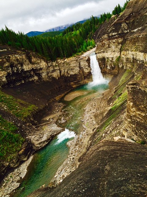
About Hummingbird Falls
Hummingbird Falls is a lesser-known alpine/foothills cascade located in western Alberta (approximate coordinates: 52.0758, -115.969). It appears to be a relatively small, steep waterfall or series of cascades fed by seasonal runoff. The feature is not widely documented in major recreational guides, and detailed trail information is scarce; descriptions below rely on general knowledge of similar remote Alberta waterfalls and the provided coordinates. Visitors should treat this as a semi-remote natural feature where access may be unmarked, involve rough terrain, and have limited facilities.
Why This Waterfall Exists
Hummingbird Falls flows over hard intrusive rock laid down about 359-419 million years ago. These resistant rocks form a durable ledge that water cannot easily wear away, creating the falls where softer material downstream has already eroded.
Nearby Falls Worth Visiting
Ram Falls (29 m) lies 9.0 kilometres to the east. Also nearby: Tapestry Falls (25 m, 18.0 km) and Table Rock Falls (11 m, 17.7 km).
Trail & Hike Details
The Approach
The easy 7.2-km out-and-back trail gains 298 metres of elevation on the way to the falls.
Trail Description
There is no widely published, maintained trail description for Hummingbird Falls in major guide sources. If a route exists it may be an unmaintained path or cross-country route that requires route-finding, scrambling over talus or logs, and stream crossings. Expect limited or no signage; follow established boot paths where present, and use map/GPS and topographic references to plan your approach. If you find a local trailhead, typical approaches to similar waterfalls in the region range from short off-trail scrambles to multi-kilometre hikes depending on where parking is available.
What to Expect
A small to moderate cascade or series of drops fed by mountain runoff. Flow will be highest in late spring/early summer from snowmelt and lower in late summer/fall unless fed by a robust watershed. Terrain around the falls may be steep and rocky with slippery surfaces near the water. Vegetation typical of subalpine and montane zones (spruce, fir, alder) and possible talus slopes. Little to no infrastructure (railings, bridges, boardwalks). Cell service may be intermittent or unavailable.
Accessibility
The trail is not wheelchair accessible. Uneven terrain and elevation changes require steady footing.
Frequently Asked Questions
🐶 Are Dogs Allowed at Hummingbird Falls?
❌ Dogs are not allowed
Are There Any Fees or Permits Required?
🆖 No fees required
🏊 Is There Swimming at Hummingbird Falls?
❌ Swimming is not allowed
When to Visit
Late spring to early summer for peak runoff and fuller waterfall flows; early fall can offer lower crowds and good weather. Winter access may be difficult and the falls may be icy or frozen.
Seasonal Access
The best time to visit is Spring, Summer, and Fall. Access roads and trails may close during winter due to snow. Check with the managing park or local authority for current conditions.
Safety Information
Potential hazards include steep and slippery rock, fast or cold water, unmarked or unmaintained approaches, stream crossings, changing mountain weather, limited or no cell reception, and wildlife encounters (bears). Use caution near the water's edge, rocks can be very slick and currents deceptively strong. Carry bear spray where appropriate, tell someone your route and expected return time, and check local advisories for road or trail closures before you go.
Current Water Conditions
3.0 m³/s
Current discharge — how much water is flowing
About average for this time of year
Based on 50 years of record
0.93 m
Water depth at gauge
7-Day Discharge Trend
What does this mean for your visit?
Flow is about average for this time of year.
About This Gauge
This gauge is on a nearby waterway and may not reflect exact conditions at the falls.
7-Day Flow Outlook
Based on the WSC gauge NORTH RAM RIVER AT FORESTRY ROAD (23 km away).
Today
Moderate
3.3 m³/s
5/10Tomorrow
Moderate
3.3 m³/s
5/10Tue
Moderate
3.1 m³/s
5/10Wed
Moderate
2.8 m³/s
8/10Thu
Moderate
2.7 m³/s
6/10Fri
Moderate
2.8 m³/s
5/10Sat
Moderate
2.5 m³/s
8/10Best window: Wed — moderate flow, mainly sunny (trip score 8/10).
Best time of year: this gauge typically runs highest from early June to mid July, peaking in June.
How we calculate this
This is a transparent outlook, not a precise forecast. We take the waterfall's current flow strength (how it ranks against its historical normal for today, from the nearest WSC stream gauge), carry that ranking forward along the gauge's seasonal curve, and nudge it for forecast rain. Confidence is highest for the next day or two and falls further out. Always check official conditions and your own judgment before visiting — high flows can be dangerous.
Know when to go.
Get a free email alert when waterfalls near Lake Louise hit peak flow. We only send when conditions are worth the trip — no weekly newsletters, no spam.
Weather Forecast
Location & Access
Getting There
Coordinates provided (52.0758, -115.969). The waterfall is in a mountainous/foothill area of western Alberta. The nearest well-known destination noted is Lake Louise (approx. 40.5 miles away). Access likely requires travel on secondary or forest roads and then a hike; road and trail conditions can vary seasonally. Confirm road access and parking with local land management agencies before visiting.
Get Directions on Google MapsParking
Not well documented. There may be limited or informal parking at a trailhead or pullout on a nearby forest road; do not rely on paved lots, toilets, or other facilities. Park only where permitted and avoid blocking gates or private driveways.
Elevation
1,709 metres above sea level
Coordinates
52.075809° N, -115.968999° W
Visitor Tips & Gear
1) Confirm access and road conditions with local land management (provincial parks, forest service) before going. 2) Wear sturdy waterproof hiking boots and expect slippery rocks near the falls. 3) Bring a map, compass/GPS and be prepared for unmarked routes. 4) Practice Leave No Trace: pack out everything, avoid disturbing vegetation and streambanks. 5) Be bear-aware: carry bear spray, make noise, and store food appropriately. 6) Do not rely on signage or facilities, plan as for a backcountry visit. 7) If you encounter private property, respect boundaries and obtain permission if required.
This trail sits at 5,607 ft above sea level
Elevated TrailUV radiation is roughly 22% stronger at this elevation than at sea level, and the dry air accelerates dehydration. Extra sun protection and fluids go a long way.
As an Amazon Associate, we earn from qualifying purchases.

Coppertone Sport SPF 50 Sunscreen
UV intensity jumps ~4% per 1,000 ft — at this elevation you can burn in half the time.

Sun Bum SPF 30 Lip Balm (3-Pack)
Lips have almost no natural UV protection and burn fast in thin, dry mountain air.

Liquid I.V. Electrolyte Packets
You lose moisture ~2x faster at elevation — electrolytes help you absorb water efficiently.

ROCKNIGHT Polarized UV400 Sunglasses
High-altitude glare off rock and water is intense — UV400 lenses block 99%+ of UVA/UVB.
As an Amazon Associate, we earn from qualifying purchases.
This easy 7.2 km hike is straightforward — comfortable trail shoes and plenty of water should do. Sun exposure on the trail makes good sun protection a must in summer.

Polarized Sunglasses (Knockaround)
Cuts glare off the water so you actually see the falls — and your photos turn out better too.

Columbia Watertight II Rain Jacket
Packs into its own pocket, seam-sealed, and keeps you dry from spray and surprise rain.

Earth Pak Waterproof Dry Bag
Keeps your phone and gear dry when waterfall mist soaks everything else.

Waterproof Phone Pouch (AiRunTech)
Cheap insurance — take photos right next to the falls without killing your phone.

Sawyer Squeeze Water Filter
The backcountry standard — filters 99.9% of bacteria and weighs just 3 oz.

JOBY GorillaPod Starter Kit
Wraps around railings and rocks for long-exposure waterfall shots — no flat surface needed.
Where to Stay
Browse vacation cabins and private rentals nearby
Unique outdoor stays — tents, yurts, and treehouses
Rent a campervan or RV for your waterfall road trip
Some links are affiliate links. We may earn a commission at no extra cost to you.
Nearby Campground
Please Pack Out Your Garbage
0.3 km away
Additional Information
Nearby Attractions
Lake Louise (approx. 40.5 miles from the provided coordinates), and general access to the Canadian Rockies and provincial forest/backcountry areas. Exact nearby named trails or attractions at the coordinates are not well-documented in major public trail databases.
Wildlife
Typical Alberta mountain and foothills wildlife, black bears (and possibly grizzly depending on exact location), elk, deer, mountain goats, moose, wolves, and a variety of smaller mammals and birds. Practice wildlife safety and store food properly.
Cities near Hummingbird Falls
Nearby Waterfalls
Writing about Hummingbird Falls? Embed this waterfall on your site for free.