Spencer Brrok Falls
Nova Scotia • 15 m
By Armen Suny · Last verified Jun 2026
Difficulty
Easy
Trail Length
1.6 km
Trail Type
Out And Back
Elevation Gain
31 m
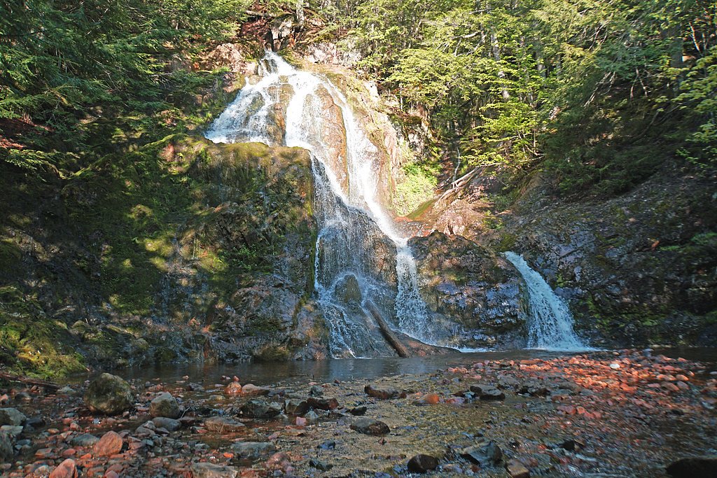
About Spencer Brrok Falls
Spencer Brook Falls (sometimes spelled Spencer Brrok Falls in informal references) is a small, local cascade on Spencer Brook in central Nova Scotia. The falls are described in visitor reports as a modest multi-step drop with rocky banks and a narrow stream channel. Water flow is highly seasonal, typically strongest during spring snowmelt and after heavy rains, and reduced to a trickle in late summer and drought conditions. The site appears to be accessed via local roads and an unmarked or lightly maintained trail; exact amenities (boardwalks, railings, formal viewpoints) are not confirmed and may be minimal or absent.
The Setting
Spencer Brrok Falls sits at 160 metres in the foothills of Nova Scotia. The falls drop 15 metres.
Height: 49 feet
Trail & Hike Details
The Approach
The easy 1.6-km out-and-back trail gains 31 metres of elevation on the way to the falls.
Trail Description
Trail access is likely a short, unmaintained footpath from a roadside pullout to the brook. Expect uneven, rocky terrain, tree roots, and possibly wet or muddy sections near the water. There may be no wayfinding signs, boardwalks, or built viewpoints. Route-finding skills and sturdy footwear are recommended. In winter the approach may be icy or snow-covered and not maintained.
What to Expect
The falls drop 15 metres.
Accessibility
The trail is not wheelchair accessible. Uneven terrain and elevation changes require steady footing.
Frequently Asked Questions
🐶 Are Dogs Allowed at Spencer Brrok Falls?
❌ Dogs are not allowed
Are There Any Fees or Permits Required?
🆖 No fees required
🏊 Is There Swimming at Spencer Brrok Falls?
❌ Swimming is not allowed
When to Visit
Spring (late March to June) for highest flows and full cascades; early morning on weekdays for solitude. Late summer and early fall may have lower flows but provide better footing and fewer insects. Winter visits are possible but bring winter traction gear and expect hazardous icy conditions.
Seasonal Access
The best time to visit is Spring, Summer, and Fall. Winter access may be limited. Check with the managing park or local authority for current conditions.
Safety Information
• Slippery rocks and unstable banks are the primary hazards, maintain good footing and keep a safe distance from edges. • Water currents and submerged hazards can be dangerous; do not assume shallow water is safe. • Winter conditions (ice, snow, hidden hazards) make the site more hazardous; use proper traction devices. • Limited or no cell coverage is possible, tell someone your plans and expected return time. • Respect private property and active forestry operations; roads may be closed during logging. • Watch for insects and ticks in warmer months; check for ticks after visiting.
Current Water Conditions
7.7 m³/s
Current discharge — how much water is flowing
Much higher than usual for this time of year
Based on 31 years of record
1.55 m
Water depth at gauge
7-Day Discharge Trend
What does this mean for your visit?
The water is flowing much higher than usual, expect an impressive display.
About This Gauge
7-Day Flow Outlook
Based on the WSC gauge GREAT VILLAGE RIVER NEAR SCRABBLE HILL (6 km away).
Today
Roaring
20 m³/s
6/10Tomorrow
Roaring
19 m³/s
8/10Tue
Roaring
17 m³/s
8/10Wed
Roaring
22 m³/s
6/10Thu
Roaring
23 m³/s
6/10Fri
Roaring
25 m³/s
6/10Sat
Roaring
23 m³/s
6/10Best window: Tomorrow — roaring flow, cloudy (trip score 8/10).
Best time of year: this gauge typically runs highest from late March to early May, peaking in April.
How we calculate this
This is a transparent outlook, not a precise forecast. We take the waterfall's current flow strength (how it ranks against its historical normal for today, from the nearest WSC stream gauge), carry that ranking forward along the gauge's seasonal curve, and nudge it for forecast rain. Confidence is highest for the next day or two and falls further out. Always check official conditions and your own judgment before visiting — high flows can be dangerous.
Know when to go.
Get a free email alert when waterfalls near Amherst hit peak flow. We only send when conditions are worth the trip — no weekly newsletters, no spam.
Weather Forecast
Location & Access
Getting There
Coordinates provided: 45.4766, -63.6568. The falls are reached from local roads off the nearest regional routes; expect a short drive on paved and possibly gravel forestry roads. Public directions are not standardized, use the coordinates for navigation. Visitors should confirm local road conditions (seasonal mud, logging activity) before travel.
Get Directions on Google MapsParking
Parking appears to be informal and limited, likely a small roadside pullout or an unpaved parking area. There may be no designated lot, signage, or facilities. Park only where permitted and avoid blocking access roads.
Elevation
160 metres above sea level
Coordinates
45.476561° N, -63.656812° W
Visitor Tips & Gear
• Use the provided coordinates and a reliable map/GPS; roads and trails may be unmarked. • Wear sturdy, closed-toe shoes with good traction; rocks are slippery when wet. • Bring insect repellent in spring and summer (black flies and mosquitoes can be significant). • Avoid walking on wet or algae-covered rocks; jump/cold water hazards are present. • Pack out all trash and respect private property, sections of the approach may cross private land or logging roads. • Check local conditions (weather, logging activity) before visiting and consider contacting local municipal offices for access details if unsure.
As an Amazon Associate, we earn from qualifying purchases.
This easy 1.6 km hike is straightforward — comfortable trail shoes and plenty of water should do. Sun exposure on the trail makes good sun protection a must in summer.

Columbia Watertight II Rain Jacket
Packs into its own pocket, seam-sealed, and keeps you dry from spray and surprise rain.

Earth Pak Waterproof Dry Bag
Keeps your phone and gear dry when waterfall mist soaks everything else.

Waterproof Phone Pouch (AiRunTech)
Cheap insurance — take photos right next to the falls without killing your phone.

Polarized Sunglasses (Knockaround)
Cuts glare off the water so you actually see the falls — and your photos turn out better too.

Osprey Daylite Daypack
Light, organized, and just the right size for a day hike — fits water, snacks, and layers.

OR Sombriolet Sun Hat
UPF 50+ sun protection with vents so your head doesn't cook on exposed trail sections.
Where to Stay
Browse vacation cabins and private rentals nearby
Unique outdoor stays — tents, yurts, and treehouses
Rent a campervan or RV for your waterfall road trip
Some links are affiliate links. We may earn a commission at no extra cost to you.
Nearby Campground
Hidden Hilltop Family Campground
10.4 km away
Additional Information
Nearby Attractions
Nearest population centers referenced by the requester: Amherst (~40.7 miles), Windsor (~45.9 miles), New Glasgow (~48.5 miles). Local attractions and services will be in these towns and smaller nearby communities; confirm distances and directions before planning a visit.
Wildlife
Expect typical Nova Scotia forest wildlife: songbirds, waterfowl, white-tailed deer, beaver, and small mammals. Black bears and moose are possible in the region, exercise normal wildlife precautions. Spring/summer insect activity (black flies, mosquitoes, ticks) can be significant.
Cities near Spencer Brrok Falls
Nearby Waterfalls
Writing about Spencer Brrok Falls? Embed this waterfall on your site for free.