Martin Brook Falls
By Armen Suny · Last verified Jun 2026
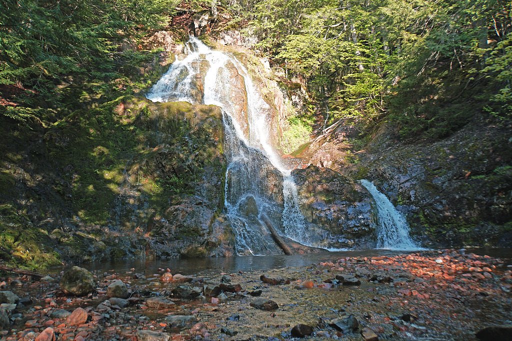
About Martin Brook Falls
Martin Brook Falls is a small, forested cascade in Nova Scotia near the coordinates 45.479, -63.6391. The falls appear as a modest multi-step drop over bedrock into a shallow pool and are set in a largely rural, wooded landscape. Information about formal facilities, official trailheads, and management is limited; visitors should plan for an informal, low‑development visit and verify local access before traveling.
Nearby Falls Worth Visiting
Spencer Brrok Falls (15 m) lies 1.4 kilometres to the west.
Trail & Hike Details
Trail Description
Reports about the route to Martin Brook Falls are sparse. Expect an unmarked or lightly marked path through mixed woodland, possibly over uneven, rooty terrain. The approach may be short (often typical for small brook waterfalls), but trail conditions, steepness, and exact routing are not consistently documented. Use caution on slippery or muddy sections and be prepared for basic bushwhack-style footing where a formal trail is absent.
What to Expect
A modest, scenic brook cascade set among trees and exposed bedrock. Flow will vary seasonally, higher in spring and after rains, lower in late summer. There may be no built viewpoints, railings, or developed facilities. Expect forest smells, insects (black flies and mosquitoes in warm months), and typical Nova Scotia woodland flora. Cell reception may be limited depending on provider and exact location.
Accessibility
The site is likely not wheelchair accessible. Expect uneven, potentially steep or muddy ground and no developed boardwalks or railings.
Frequently Asked Questions
🐶 Are Dogs Allowed at Martin Brook Falls?
❌ Dogs are not allowed
Are There Any Fees or Permits Required?
🆖 No fees required
🏊 Is There Swimming at Martin Brook Falls?
❌ Swimming is not allowed
When to Visit
Late spring for higher flows and fewer biting insects than early summer; summer and early fall offer milder weather and scenic forest conditions. Avoid visiting after heavy rain without caution, short-term flooding and faster currents can increase hazards. Winter visits are possible but may be icy and require specialist gear.
Seasonal Access
The best time to visit is Spring, Summer, and Fall. Winter access may be limited. Check with the managing park or local authority for current conditions.
Safety Information
Potential hazards include slippery and uneven rock surfaces, sudden water-level increases after rain, limited or no formal trail markers, minimal or no signage, and limited cell service. There may be no lifeguard or emergency infrastructure. In winter, ice build-up and hidden hazards increase risk. Wear appropriate footwear, stay off wet ledges, supervise children closely, and avoid risky photo opportunities near the edge. If unsure about land access, contact local municipal offices or landowners before visiting.
Current Water Conditions
7.7 m³/s
Current discharge — how much water is flowing
Much higher than usual for this time of year
Based on 31 years of record
1.55 m
Water depth at gauge
7-Day Discharge Trend
What does this mean for your visit?
The water is flowing much higher than usual, expect an impressive display.
About This Gauge
7-Day Flow Outlook
Based on the WSC gauge GREAT VILLAGE RIVER NEAR SCRABBLE HILL (6 km away).
Today
Roaring
20 m³/s
6/10Tomorrow
Roaring
19 m³/s
8/10Tue
Roaring
17 m³/s
8/10Wed
Roaring
22 m³/s
6/10Thu
Roaring
23 m³/s
6/10Fri
Roaring
25 m³/s
6/10Sat
Roaring
23 m³/s
6/10Best window: Tomorrow — roaring flow, cloudy (trip score 8/10).
Best time of year: this gauge typically runs highest from late March to early May, peaking in April.
How we calculate this
This is a transparent outlook, not a precise forecast. We take the waterfall's current flow strength (how it ranks against its historical normal for today, from the nearest WSC stream gauge), carry that ranking forward along the gauge's seasonal curve, and nudge it for forecast rain. Confidence is highest for the next day or two and falls further out. Always check official conditions and your own judgment before visiting — high flows can be dangerous.
Know when to go.
Get a free email alert when waterfalls near Amherst hit peak flow. We only send when conditions are worth the trip — no weekly newsletters, no spam.
Weather Forecast
Location & Access
Getting There
The falls are located at approximately 45.479, -63.6391 in Nova Scotia. Nearest population centers (approximate driving distances): Amherst (~41.3 miles), Windsor (~46.8 miles), New Glasgow (~47.6 miles). Access is likely from local secondary roads and a short forest path; exact public trailhead locations are not well documented. Confirm local directions and land-ownership (public vs. private) before visiting.
Get Directions on Google MapsParking
Parking may be limited to a roadside pull-off or informal parking area close to the access point. There may be little or no formal parking lot, signage, or facilities. Park safely off the road and avoid blocking private driveways.
Elevation
148 metres above sea level
Coordinates
45.479026° N, -63.639072° W
Visitor Tips & Gear
1) Check local maps and land‑ownership before visiting, some approaches may cross private land. 2) Wear sturdy, grippy footwear; wet rocks are slippery. 3) Bring insect repellent in spring/summer. 4) Avoid going onto wet rock ledges or the lip of the falls. 5) Leave no trace and pack out all trash. 6) If conditions are icy or snowy, consider postponing or using traction devices.
Where to Stay
Browse vacation cabins and private rentals nearby
Unique outdoor stays — tents, yurts, and treehouses
Rent a campervan or RV for your waterfall road trip
Some links are affiliate links. We may earn a commission at no extra cost to you.
Nearby Campground
Hidden Hilltop Family Campground
9.3 km away
Additional Information
Nearby Attractions
Nearby towns include Amherst, Windsor, and New Glasgow (distances as supplied). The surrounding region offers coastal viewpoints, provincial parks, and rural scenic drives, but specific nearby attractions and distances should be confirmed locally.
Wildlife
Typical Nova Scotia wildlife may be encountered: white‑tailed deer, small mammals (rabbits, squirrels), many bird species, beavers in waterways, and potentially black bear or moose in more remote areas. Ticks and black flies can be a nuisance in warmer months.
Cities near Martin Brook Falls
Nearby Waterfalls
Writing about Martin Brook Falls? Embed this waterfall on your site for free.