Sawmill Creek Falls
By Armen Suny · Last verified Jun 2026
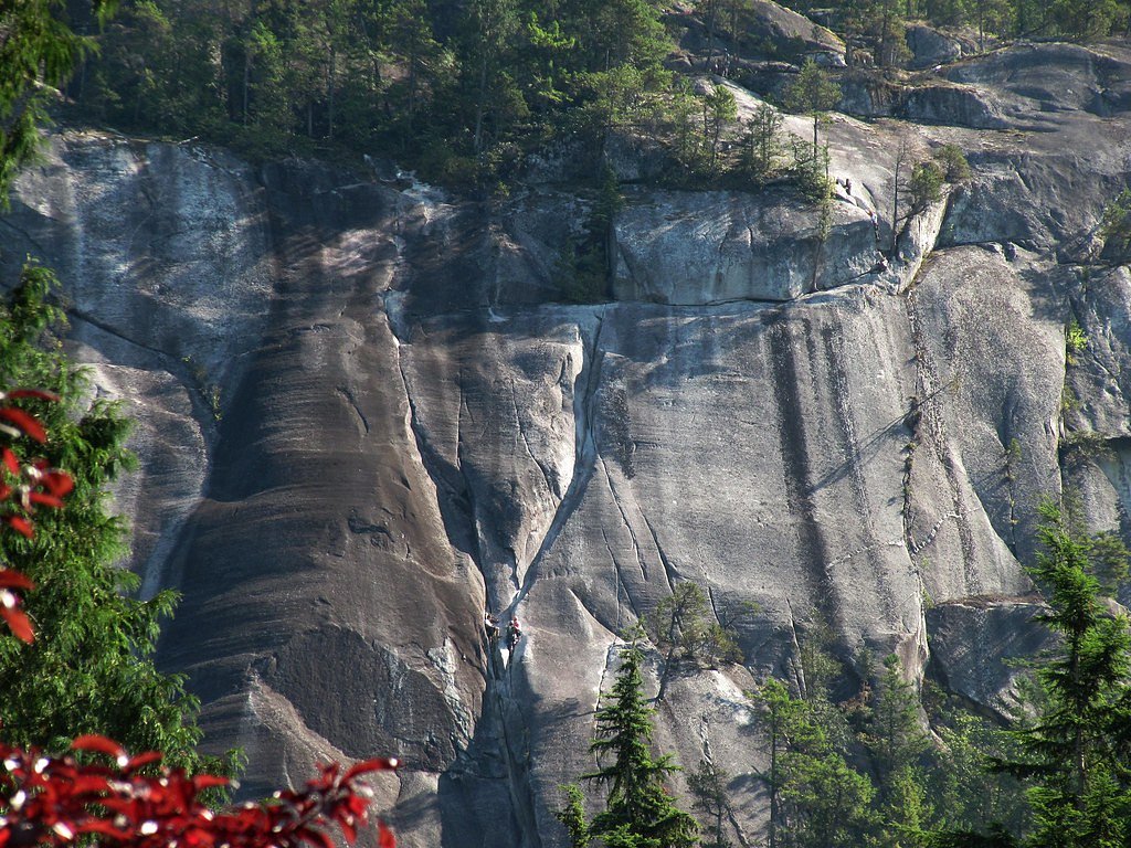
About Sawmill Creek Falls
Sawmill Creek Falls is a forested, multi-step cascade on Sawmill Creek near the Chilliwack area of British Columbia (approx. coordinates 49.6127, -121.4134). The falls occur in a narrow, wooded valley and are most commonly visited by people willing to travel on gravel/forestry roads and follow an unmaintained spur or short scramble to viewpoint(s). Flow and appearance vary seasonally, with highest flows in spring and early summer from snowmelt. Specific route details and official infrastructure appear limited, so visitors should be prepared for informal access and variable trail conditions.
Why This Waterfall Exists
Sawmill Creek Falls flows over cemented gravel rock, primarily conglomerate and sandstone, laid down about 145-299 million years ago. These soft rocks erode readily, allowing the stream to carve a vertical drop into the landscape.
Nearby Falls Worth Visiting
Aqueduct Falls (100 m) lies 2.9 kilometres to the northeast. Also nearby: Yale Creek Falls (15 m, 4.7 km).
Trail & Hike Details
Trail Description
There is no widely maintained, signed trail to Sawmill Creek Falls. Typical visits use a forestry road to a turning area or pullout, then an unmarked spur or cross-country route down through forest and over rough ground to reach viewpoints. Terrain may include loose rock, muddy sections, and steep sides near the creek. Expect routefinding and some scrambling; use caution near the creek edge and steep drops.
What to Expect
Expect a forested setting with a series of cascades or tiers rather than a single, tall free-fall. The creek flows through a narrow channel with rocky banks and dense vegetation. There are likely only informal viewpoints; no developed railings or platforms. Flow varies seasonally, highest in spring/early summer and lower in late summer or during dry periods. Cell service may be intermittent in the area.
Accessibility
Access is likely not wheelchair accessible. The approach uses gravel/forestry roads and an unmaintained, potentially steep spur or scramble; expect uneven terrain and no developed facilities.
Frequently Asked Questions
🐶 Are Dogs Allowed at Sawmill Creek Falls?
❌ Dogs are not allowed
Are There Any Fees or Permits Required?
🆖 No fees required
🏊 Is There Swimming at Sawmill Creek Falls?
❌ Swimming is not allowed
When to Visit
Late spring to early summer for highest flows and dramatic water; early fall for lower crowds and stable weather. Winter visits are possible but can be icy, snowy, and more hazardous, roads may be closed or impassable.
Seasonal Access
The best time to visit is Spring, Summer, Fall, and Winter. Check with the managing park or local authority for current conditions.
Safety Information
• Slippery rocks, steep banks, and unstable edges present real hazards, stay back from the creek edge and supervise children. • Water flow can increase rapidly during rain or snowmelt; avoid wading or swimming near strong currents. • Forestry roads can be rough, narrow, and subject to logging traffic; watch for gates and signage. • Cell service may be unreliable. Carry a map, emergency supplies, and tell someone your plan and expected return time. • Seasonal hazards include snow, ice, and falling branches during storms. Be cautious during winter and shoulder seasons.
Current Water Conditions
1.2 m³/s
Current discharge — how much water is flowing
Much lower than usual for this time of year
Based on 56 years of record
1.92 m
Water depth at gauge
7-Day Discharge Trend
What does this mean for your visit?
Flow is well below normal for this time of year, so the waterfall may be a trickle.
About This Gauge
This gauge is on a nearby waterway and may not reflect exact conditions at the falls.
7-Day Flow Outlook
Based on the WSC gauge COQUIHALLA RIVER BELOW NEEDLE CREEK (23 km away).
Today
Barely Flowing
1.2 m³/s
5/10Tomorrow
Barely Flowing
1.2 m³/s
4/10Tue
Barely Flowing
1.2 m³/s
4/10Wed
Barely Flowing
1.2 m³/s
4/10Thu
Barely Flowing
1.1 m³/s
4/10Fri
Barely Flowing
1.1 m³/s
5/10Sat
Barely Flowing
1.1 m³/s
3/10Best window: Today — barely flowing flow, mainly sunny (trip score 5/10).
Best time of year: this gauge typically runs highest from mid April to mid July, peaking in June.
How we calculate this
This is a transparent outlook, not a precise forecast. We take the waterfall's current flow strength (how it ranks against its historical normal for today, from the nearest WSC stream gauge), carry that ranking forward along the gauge's seasonal curve, and nudge it for forecast rain. Confidence is highest for the next day or two and falls further out. Always check official conditions and your own judgment before visiting — high flows can be dangerous.
Know when to go.
Get a free email alert when waterfalls near Chilliwack hit peak flow. We only send when conditions are worth the trip — no weekly newsletters, no spam.
Weather Forecast
Location & Access
Getting There
The falls are accessed from the general Chilliwack/Sawmill Creek area (coordinates 49.6127, -121.4134). Approaches commonly use secondary/forestry roads off the main regional highways; the final approach often involves gravel logging roads and a short, unmaintained footpath or scramble down to the creek. Expect rough road surfaces and possible gated or seasonally closed roads. Confirm conditions locally (park or regional district) before travelling.
Get Directions on Google MapsParking
Parking is typically informal (pullouts or small clearings beside forestry roads). There is no developed parking lot or visitor services at the falls. Park legally and avoid blocking gates or private driveways. Parking may be limited and could require extra walking if pullouts are full.
Elevation
177 metres above sea level
Coordinates
49.612746° N, -121.413431° W
Visitor Tips & Gear
• Check current road/forest service conditions before heading out; forestry roads may be gated, rough, or seasonally closed. • Wear sturdy footwear and bring trekking poles for stability on rough or muddy sections. • Park responsibly off the roadway and avoid blocking gates or driveways. • Treat the area as backcountry: bring a map/GPS, emergency kit, and let someone know your plans. • Respect private property and posted signs. If access crosses private lands, get permission when required. • Be cautious near slick rocks and fast water; current and hydraulics can be hazardous.
Where to Stay
Browse vacation cabins and private rentals nearby
Unique outdoor stays — tents, yurts, and treehouses
Rent a campervan or RV for your waterfall road trip
Some links are affiliate links. We may earn a commission at no extra cost to you.
Nearby Campground
Emory Bar RV Park
10.3 km away
Additional Information
Nearby Attractions
Nearby recreational areas and attractions in the broader Chilliwack region include Chilliwack Lake Provincial Park, local hiking routes on Mount Cheam and surrounding peaks, and regional waterfalls and lakes. Distances to larger towns in the region: Chilliwack (~44.5 miles from the referenced points), Glacier (~57.3 miles), Maple Falls (~62.8 miles, distances provided by the request).
Wildlife
Typical fauna for the area may include black bears, deer, small mammals, and birds. Take standard precautions for wildlife: store food securely, keep a clean campsite, and make noise when hiking to avoid startling animals. Cougar sightings are possible in regional backcountry areas; follow local safety guidance.
Cities near Sawmill Creek Falls
Nearby Waterfalls
Writing about Sawmill Creek Falls? Embed this waterfall on your site for free.