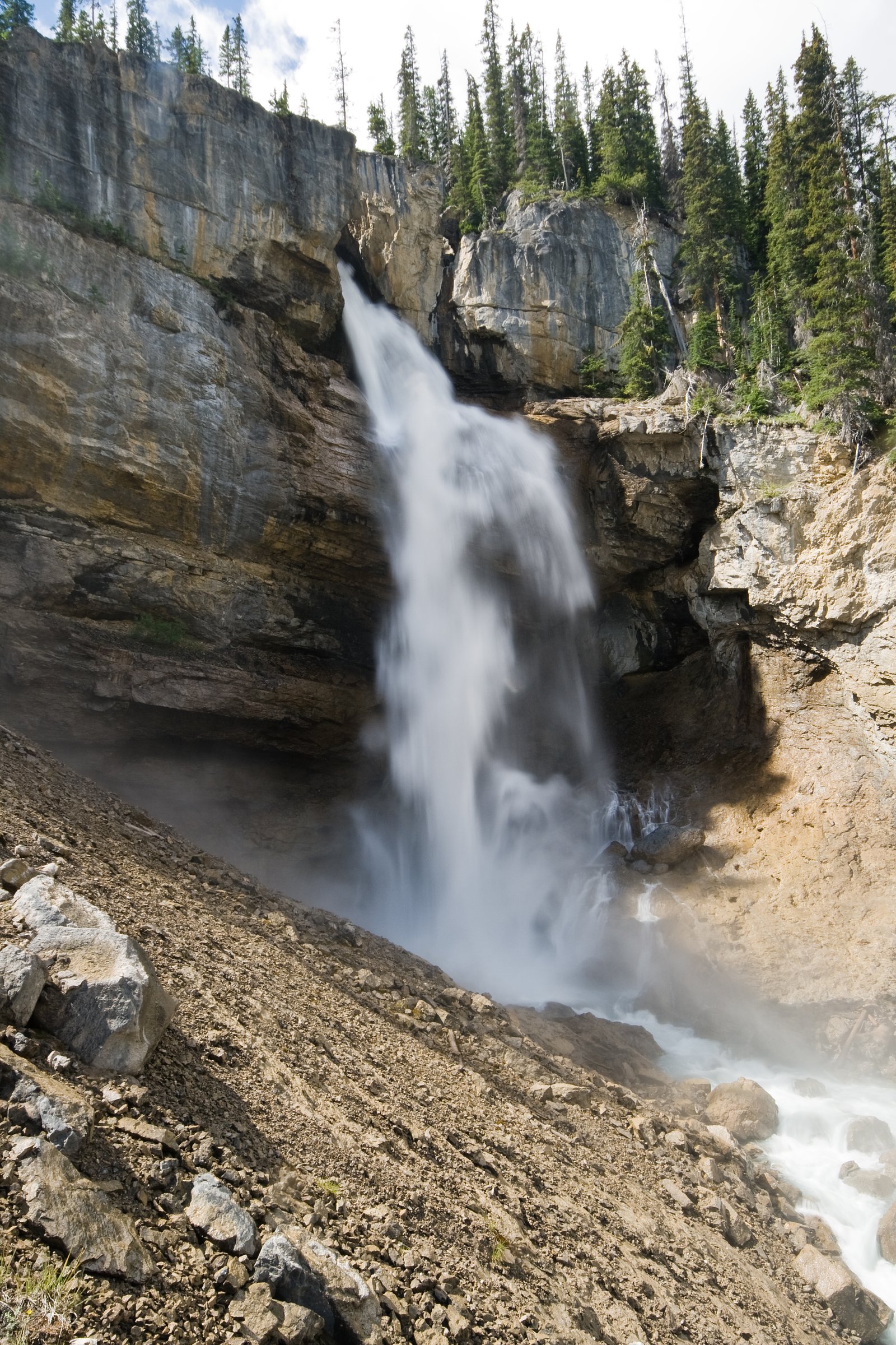
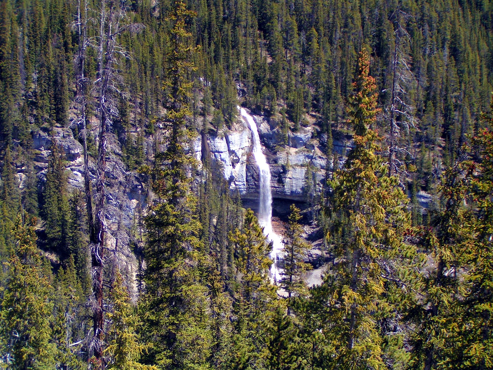
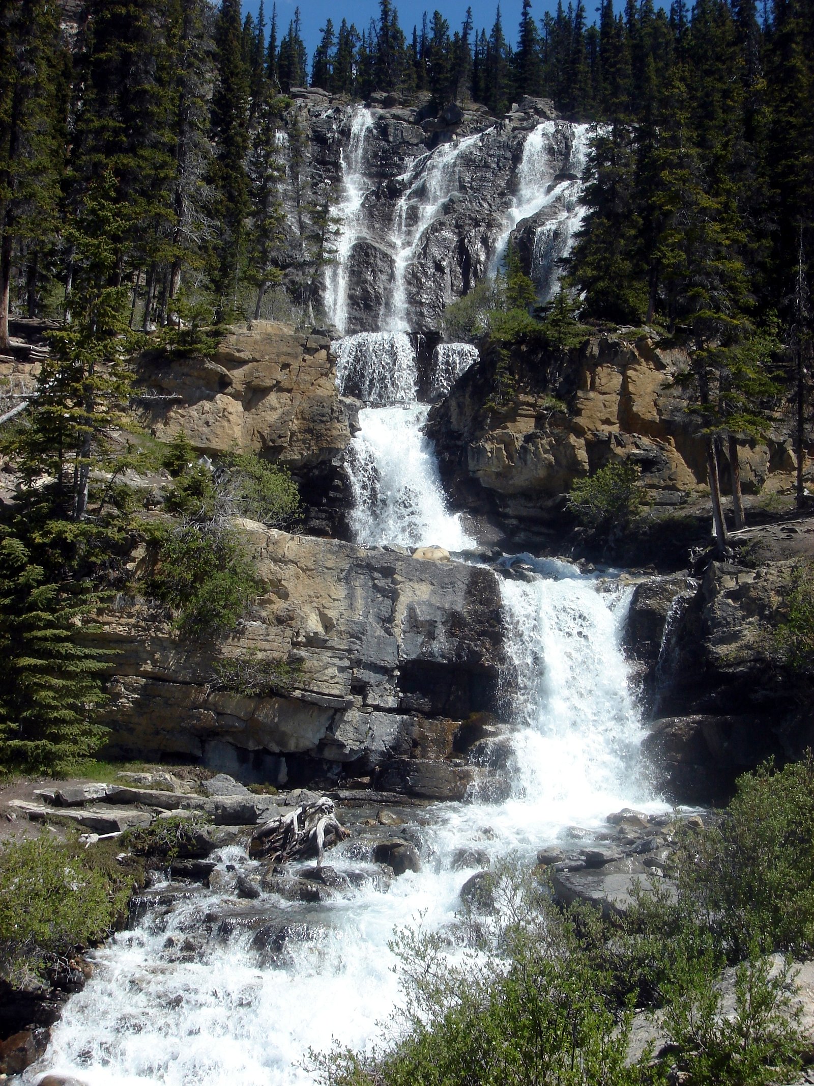
Panther Falls
Alberta • Banff National Park • 66 m
By Armen Suny · Last verified Jun 2026
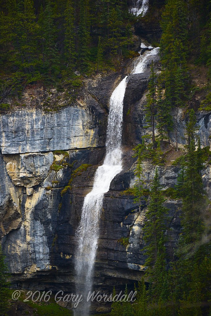

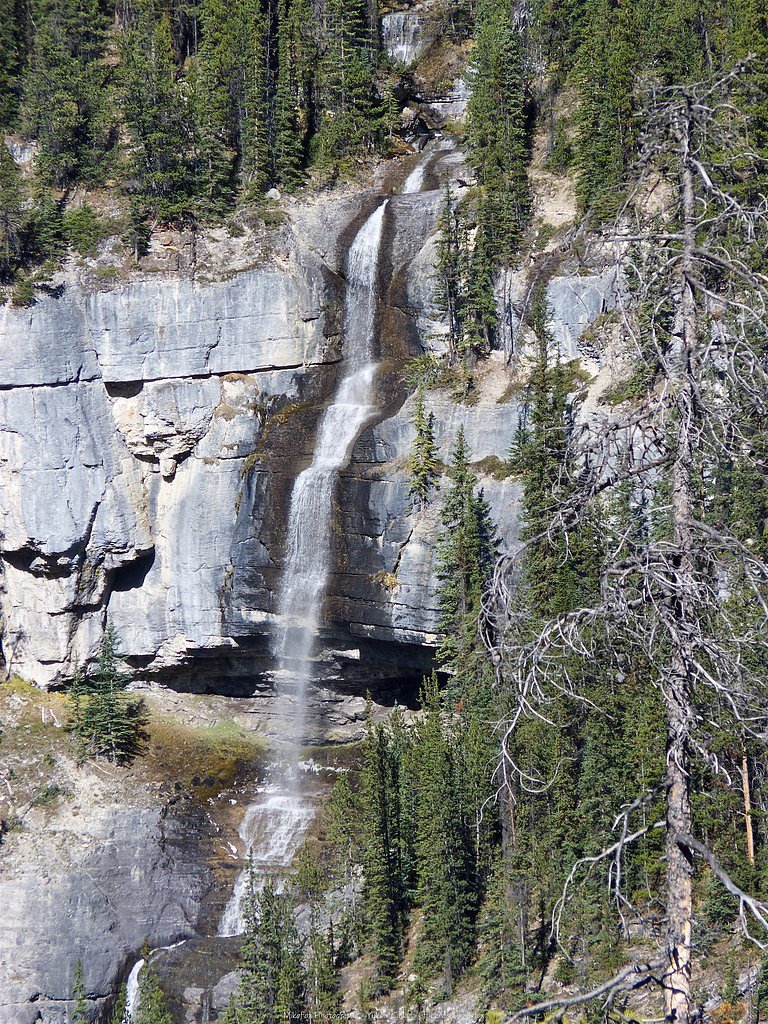

Photo Credits (4)
Difficulty
Easy
Trail Length
1.3 km
Trail Type
Out And Back
Elevation Gain
73 m
About Panther Falls
Panther Falls are a series of waterfalls in Banff National Park, Alberta, Canada. It is developed on Nigel Creek and its waters originate in Nigel Pass, between the slopes of Cirrus Mountain and Nigel Peak in the Parker Ridge of the Canadian Rockies.
The Setting
Panther Falls sits at 1,827 metres within Banff National Park, in the high mountains of Alberta. At 66 metres, it is among the taller waterfalls in Alberta.
Why This Waterfall Exists
Panther Falls flows over layered sedimentary rock laid down about 323-419 million years ago. Over time, the stream has worn through these layers at different rates, creating a 217-foot drop that forms the waterfall.
Nearby Falls Worth Visiting
Bridal Veil Falls, the tallest waterfall in Alberta at 366 metres, lies 0.3 kilometres to the east. Also nearby: Tangle Creek (48 m, 18.2 km).
Trail & Hike Details
The Approach
The easy 1.3-km out-and-back trail gains 73 metres of elevation on the way to the falls.
Trail Description
There is little formal documentation describing a maintained trail to Panther Falls. If a short access path exists, it may be rough, steep in places, and unmarked. Approach routes likely involve short off-trail sections or informal paths from a roadside turnout to a viewpoint. Expect uneven, rocky, and possibly muddy terrain; route-finding skills may be required.
What to Expect
The falls plunge 66 metres over layered sedimentary rock.
Accessibility
The trail is not wheelchair accessible. Uneven terrain and elevation changes require steady footing.
Frequently Asked Questions
🐶 Are Dogs Allowed at Panther Falls?
❌ Dogs are not allowed
Are There Any Fees or Permits Required?
🆖 No fees required
🏊 Is There Swimming at Panther Falls?
❌ Swimming is not allowed
When to Visit
Late spring to early summer for the strongest flows (snowmelt). Summer offers the easiest access and generally milder weather. Fall can provide good colors but lower water flow. Winter may present frozen features but also hazardous icy conditions and increased avalanche/icefall risk; only attempt winter visits if experienced and properly equipped.
Seasonal Access
The best time to visit is Spring, Summer, and Fall. Access roads and trails may close during winter due to snow. Check with Banff National Park for current conditions.
Safety Information
Potential hazards include slippery rocks, steep drop-offs, cold and fast-moving water, rapidly changing mountain weather, loose or unstable terrain, and wildlife encounters. Roads and pullouts can be busy and exposed to traffic. Use caution near edges and do not climb on unstable rock. Check avalanche or ice conditions in winter. Always tell someone your plans and expected return time.
Current Water Conditions
8.4 m³/s
Current discharge — how much water is flowing
Much higher than usual for this time of year
Based on 67 years of record
1.17 m
Water depth at gauge
7-Day Discharge Trend
What does this mean for your visit?
The water is flowing much higher than usual, expect an impressive display.
About This Gauge
This gauge is on a nearby waterway and may not reflect exact conditions at the falls.
7-Day Flow Outlook
Based on the WSC gauge SUNWAPTA RIVER AT ATHABASCA GLACIER (12 km away).
Today
Roaring
9.0 m³/s
6/10Tomorrow
Roaring
8.6 m³/s
6/10Tue
Roaring
8.1 m³/s
8/10Wed
Roaring
8.8 m³/s
6/10Thu
Roaring
8.5 m³/s
8/10Fri
Roaring
8.8 m³/s
6/10Sat
Roaring
8.2 m³/s
9/10Best window: Sat — roaring flow, mainly sunny (trip score 9/10).
Best time of year: this gauge typically runs highest from early July to mid August, peaking in July.
How we calculate this
This is a transparent outlook, not a precise forecast. We take the waterfall's current flow strength (how it ranks against its historical normal for today, from the nearest WSC stream gauge), carry that ranking forward along the gauge's seasonal curve, and nudge it for forecast rain. Confidence is highest for the next day or two and falls further out. Always check official conditions and your own judgment before visiting — high flows can be dangerous.
Know when to go.
Get a free email alert when waterfalls near Jasper hit peak flow. We only send when conditions are worth the trip — no weekly newsletters, no spam.
Weather Forecast
Location & Access
Getting There
The waterfall is located in the Jasper region (coordinates 52.1817, -117.0577). The most likely access is from a pullout or minor side road near the Icefields Parkway / regional highways that service Jasper National Park; exact trailhead signage and parking may be minimal or unmarked. Use a detailed map, GPS coordinates, or contact Parks Canada/Jasper visitor centre for the most current access directions.
Get Directions on Google MapsParking
Parking may be limited to highway pullouts or informal gravel turnouts. Expect no formal lot, restrooms, or services. Park safely off the roadway and avoid blocking traffic.
Elevation
1,827 metres above sea level
Coordinates
52.181662° N, -117.057671° W
Land Management
Managed by Parks Canada Agency
Visitor Tips & Gear
• Check conditions and access with Parks Canada or Jasper visitor centre before visiting. • Wear sturdy, waterproof footwear; watch for slippery rocks and wet trails. • Stay back from cliff edges and fast-moving water. • Carry a map, GPS with the provided coordinates, and extra layers; weather can change quickly. • Carry bear spray in bear country and know how to use it. • Do not rely on roadside pullouts if traffic is heavy, park well off the road and safely. • Pack out all trash. • If unsure about the route or safety, consider visiting more developed nearby waterfalls in Jasper National Park instead.
This trail sits at 5,994 ft above sea level
Elevated TrailUV radiation is roughly 24% stronger at this elevation than at sea level, and the dry air accelerates dehydration. Extra sun protection and fluids go a long way.
As an Amazon Associate, we earn from qualifying purchases.

Coppertone Sport SPF 50 Sunscreen
UV intensity jumps ~4% per 1,000 ft — at this elevation you can burn in half the time.

Sun Bum SPF 30 Lip Balm (3-Pack)
Lips have almost no natural UV protection and burn fast in thin, dry mountain air.

Liquid I.V. Electrolyte Packets
You lose moisture ~2x faster at elevation — electrolytes help you absorb water efficiently.

ROCKNIGHT Polarized UV400 Sunglasses
High-altitude glare off rock and water is intense — UV400 lenses block 99%+ of UVA/UVB.
As an Amazon Associate, we earn from qualifying purchases.
For this easy 1.3 km trail, lightweight trail shoes and a water bottle are usually sufficient. Sun exposure on the trail makes good sun protection a must in summer.

Polarized Sunglasses (Knockaround)
Cuts glare off the water so you actually see the falls — and your photos turn out better too.

Columbia Watertight II Rain Jacket
Packs into its own pocket, seam-sealed, and keeps you dry from spray and surprise rain.

Earth Pak Waterproof Dry Bag
Keeps your phone and gear dry when waterfall mist soaks everything else.

Waterproof Phone Pouch (AiRunTech)
Cheap insurance — take photos right next to the falls without killing your phone.

JOBY GorillaPod Starter Kit
Wraps around railings and rocks for long-exposure waterfall shots — no flat surface needed.

Osprey Daylite Daypack
Light, organized, and just the right size for a day hike — fits water, snacks, and layers.
Where to Stay
Browse vacation cabins and private rentals nearby
Unique outdoor stays — tents, yurts, and treehouses
Rent a campervan or RV for your waterfall road trip
Some links are affiliate links. We may earn a commission at no extra cost to you.
Nearby Campground
Wilcox Creek Campground
9.1 km away
Additional Information
Nearby Attractions
The waterfall is in the broader Jasper region; well-known nearby attractions in Jasper National Park include Athabasca Falls, Sunwapta Falls, Maligne Lake, and the Columbia Icefield (distances vary). Confirm exact proximity and access routes with local maps and visitor centres.
Wildlife
Bears (black and grizzly), moose, elk, deer, mountain goats, and smaller mammals and birds may be present. Practice standard wildlife safety: keep distance, store food properly, and carry bear spray where required.
Cities near Panther Falls
Nearby Waterfalls
Other waterfalls named Panther Falls
2 other waterfalls share this name across Canada.
Writing about Panther Falls? Embed this waterfall on your site for free.