Difficulty
Easy
Trail Length
1.6 km
Trail Type
Out And Back
About Oink Oink Falls
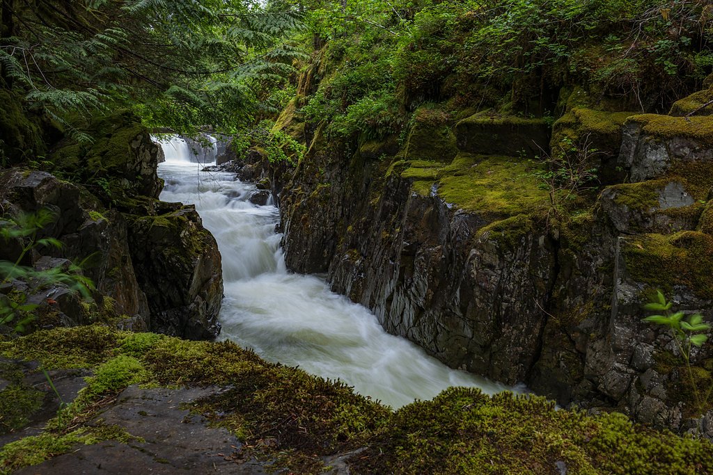
Oink Oink Falls is a little-documented waterfall located on Vancouver Island, British Columbia, at approximately 49.8181, -125.3155. It appears to be a small coastal cascade or series of cascades in a forested stream drainage. Public information about the falls is limited; the waterfall's exact height, official name origin, and formal access route are not well documented in major guide resources. Visitors should treat descriptions here as provisional and expect route-finding and unmaintained terrain.
Why This Waterfall Exists
Oink Oink Falls flows over volcanic rock laid down about 201-252 million years ago. These resistant rocks form a durable ledge that water cannot easily wear away, creating the falls where softer material downstream has already eroded.
Trail & Hike Details
Trail Description
There is limited public trail information for Oink Oink Falls. If reachable by land, expect an unmarked or minimally maintained route through coastal second-growth and older forest typical of Vancouver Island. Route-finding may be required; short bushwhacks, wet ground, and multiple small stream crossings are possible. Depending on final approach, there may be short steep sections or slippery rock slabs near the water. If approaching via water (boat or kayak) from nearby inlets, landing locations may be rocky and exposed to tides and weather.
What to Expect
A small, likely seasonal-to-perennial cascade in a forested stream. Flow will be highest in spring and after heavy rain; summer flows may be reduced. The setting is likely quiet and remote with limited visitor infrastructure (no railings, viewing platforms, or restrooms). Expect natural hazards common to coastal Vancouver Island waterfalls: wet and slippery rocks, unstable banks, and limited cell reception. Wildlife in the area may include black bears, deer, and bald eagles.
Accessibility
The trail is not wheelchair accessible. Uneven terrain and elevation changes require steady footing.
Frequently Asked Questions
🐶 Are Dogs Allowed at Oink Oink Falls?
❌ Dogs are not allowed
Are There Any Fees or Permits Required?
🆖 No fees required
🏊 Is There Swimming at Oink Oink Falls?
❌ Swimming is not allowed
When to Visit
Late spring and early summer for the highest water flow and more reliable stream volume. Summer offers easier access on dry roads but lower flows. Fall can offer good colors and cooler conditions but may coincide with increased rain and slippery conditions. Winter may be cold, wet, and icy and access roads or trails may be closed or hazardous.
Seasonal Access
The best time to visit is Spring, Summer, and Fall. Winter access may be limited. Check with the managing park or local authority for current conditions.
Safety Information
Exercise caution: slippery rocks, undercut banks, fast or cold water, and poor footing are common hazards. Logging roads can be gated or closed and may have heavy vehicle traffic. Cell service may be unreliable. Check weather forecasts, road conditions, and local advisories before travel. If you encounter wildlife, keep a safe distance and follow local wildlife safety guidelines.
Current Water Conditions
5.9 m³/s
Current discharge — how much water is flowing
About average for this time of year
Based on 50 years of record
0.86 m
Water depth at gauge
7-Day Discharge Trend
What does this mean for your visit?
Flow is about average for this time of year.
About This Gauge
This gauge is on a nearby waterway and may not reflect exact conditions at the falls.
7-Day Flow Outlook
Based on the WSC gauge OYSTER RIVER BELOW WOODHUS CREEK (10 km away).
Today
Moderate
5.9 m³/s
8/10Tomorrow
Moderate
5.7 m³/s
9/10Tue
Moderate
5.4 m³/s
8/10Wed
Moderate
5.5 m³/s
6/10Thu
Moderate
5.4 m³/s
6/10Fri
Moderate
4.9 m³/s
8/10Sat
Moderate
4.7 m³/s
6/10Best window: Tomorrow — moderate flow, sunny (trip score 9/10).
Best time of year: this gauge typically runs highest from mid April to late June, peaking in May.
How we calculate this
This is a transparent outlook, not a precise forecast. We take the waterfall's current flow strength (how it ranks against its historical normal for today, from the nearest WSC stream gauge), carry that ranking forward along the gauge's seasonal curve, and nudge it for forecast rain. Confidence is highest for the next day or two and falls further out. Always check official conditions and your own judgment before visiting — high flows can be dangerous.
Know when to go.
Get a free email alert when waterfalls near Campbell River hit peak flow. We only send when conditions are worth the trip — no weekly newsletters, no spam.
Weather Forecast
Location & Access
Getting There
Coordinates: 49.8181, -125.3155. The falls are in a coastal/forested area of Vancouver Island, roughly in the general vicinity of Campbell River (about 12–13 miles), Courtenay (about 20 miles), and farther from Powell River across the Strait. Access may require travel on secondary or logging roads off the main island highways and a short hike; there does not appear to be a widely published, maintained trailhead. Exact public access points are not well documented. Visitors should plan to use topographic maps, GPS, and local forest service/municipal resources for the most current road and access info.
Get Directions on Google MapsParking
There is no documented formal parking area. Expect informal pullouts or small clearings on forestry or logging roads where parking may be possible. Park safely and off the road. Because conditions and closures on logging roads can change, verify current road status before driving in.
Elevation
544 metres above sea level
Coordinates
49.818059° N, -125.315500° W
Visitor Tips & Gear
• Confirm current logging road and trail access with local authorities or forestry offices before visiting. • Use GPS coordinates and a topographic map; trails may be unmarked. • Wear sturdy, waterproof footwear and bring traction for wet rocks. • Be prepared for mosquitos and biting insects in spring/summer. • Carry bear spray and know how to use it; make noise while approaching streams where visibility is limited. • Do not rely on a single vehicle, cell coverage may be poor; tell someone your plan and expected return. • Avoid venturing onto wet rock near edges; currents and undercut banks can be hazardous.
Where to Stay
Browse vacation cabins and private rentals nearby
Unique outdoor stays — tents, yurts, and treehouses
Rent a campervan or RV for your waterfall road trip
Some links are affiliate links. We may earn a commission at no extra cost to you.
Nearby Campground
Croteau Lake Group Campsite
12.8 km away
Additional Information
Nearby Attractions
Nearby population centers include Campbell River and Courtenay; known nearby natural attractions that visitors often visit in the broader region include Elk Falls (near Campbell River) and Strathcona Provincial Park inland. Exact proximity and driving routes will vary; consult local maps and visitor information for current recommendations.
Wildlife
Typical coastal Vancouver Island wildlife may be present: black bears, cougars (rare), deer, eagles, and salmon runs in some stream systems. Be especially cautious during salmon spawning season and in bear country.
Cities near Oink Oink Falls
Nearby Waterfalls
Writing about Oink Oink Falls? Embed this waterfall on your site for free.