McKay Creek Falls
British Columbia • 30 m
By Armen Suny · Last verified Jun 2026
Photo Credits (1)
About McKay Creek Falls
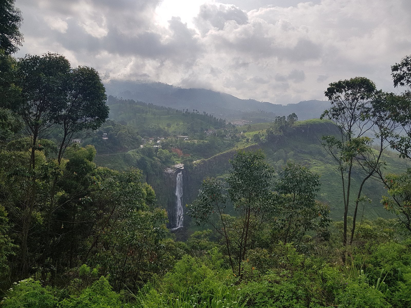
McKay Creek Falls (approx. coords 49.0739, -122.177) is a small, forested cascade on McKay Creek just west of Abbotsford in the Sumas/Peaceful Valley area of British Columbia. The waterfall is typically reached by a short hike through mixed second-growth forest and riparian brush. Flow is highest in spring and after heavy rain; in summer the falls may be reduced to a smaller cascade. Specific published details on exact height and formal developed viewpoints are limited, so descriptions below include conservative guidance and may be approximate.
The Setting
McKay Creek Falls sits at 125 metres in the coastal lowlands of British Columbia. The falls drop 30 metres.
Why This Waterfall Exists
McKay Creek Falls flows over Harrison Lake Formation, a hard volcanic rock layer deposited about 175-201 million years ago. These resistant rocks form a durable ledge that water cannot easily wear away, creating a 98-foot drop where softer material downstream has already eroded.
Trail & Hike Details
Trail Description
Trail access to McKay Creek Falls is typically via informal or lightly developed forest trails. Expect narrow, sometimes overgrown paths with roots, downed wood and occasional muddy or rocky sections. The approach usually follows or crosses small tributary streams; near the creek banks terrain can be steep and slippery. There may be limited or no constructed viewpoints or railings, exercise caution near the water's edge.
What to Expect
The falls cascade 30 metres over hard volcanic rock.
Accessibility
Likely not wheelchair- or stroller-accessible. Trails are natural surface with roots, rocks and uneven terrain; steep or narrow sections may be present.
Frequently Asked Questions
🐶 Are Dogs Allowed at McKay Creek Falls?
❌ Dogs are not allowed
Are There Any Fees or Permits Required?
🆖 No fees required
🏊 Is There Swimming at McKay Creek Falls?
❌ Swimming is not allowed
When to Visit
Late spring (snowmelt and higher runoff) for stronger flows and lush vegetation. Early fall can offer cooler weather and lower crowds. Summer offers easier, drier trails but lower water flow. Winter visits are possible but trails and creek banks can be icy and hazardous.
Seasonal Access
The best time to visit is Spring, Summer, Fall, and Winter. Check with the managing park or local authority for current conditions.
Safety Information
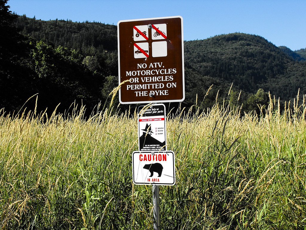
• Slippery rocks and steep, unstable banks near the creek, keep a safe distance from edges. • High water and strong currents after storms and in spring, avoid entering the water. • Minimal or no cell coverage in some spots, tell someone your plans and expected return time. • Limited or no facilities (no toilets, no potable water), plan accordingly. • Wildlife awareness: store food securely and keep dogs under control. • Trails may cross private property in places; respect posted signs and closures.
Current Water Conditions
0.6 m³/s
Current discharge — how much water is flowing
Lower than usual for this time of year
Based on 69 years of record
0.66 m
Water depth at gauge
7-Day Discharge Trend
What does this mean for your visit?
Flow is lower than usual for this time of year.
About This Gauge
This gauge is on a nearby waterway and may not reflect exact conditions at the falls.
7-Day Flow Outlook
Based on the WSC gauge SUMAS RIVER NEAR HUNTINGDON (9 km away).
Today
Low
0.5 m³/s
5/10Tomorrow
Low
0.5 m³/s
5/10Tue
Low
0.5 m³/s
5/10Wed
Low
0.5 m³/s
5/10Thu
Low
0.5 m³/s
4/10Fri
Low
0.5 m³/s
5/10Sat
Low
0.5 m³/s
5/10Best window: Today — low flow, cloudy (trip score 5/10).
Best time of year: this gauge typically runs highest from early December to early February, peaking in January.
How we calculate this
This is a transparent outlook, not a precise forecast. We take the waterfall's current flow strength (how it ranks against its historical normal for today, from the nearest WSC stream gauge), carry that ranking forward along the gauge's seasonal curve, and nudge it for forecast rain. Confidence is highest for the next day or two and falls further out. Always check official conditions and your own judgment before visiting — high flows can be dangerous.
Know when to go.
Get a free email alert when waterfalls near Abbotsford hit peak flow. We only send when conditions are worth the trip — no weekly newsletters, no spam.
Weather Forecast
Location & Access
Getting There
General location: near Abbotsford (approx 6.4 miles), Peaceful Valley (approx 7.2 miles) and Sumas (approx 7.7 miles). Coordinates: 49.0739, -122.177. Access is generally from local roads and trailheads in the Sumas/McKay Creek watershed area; there may not be a formal or signed trailhead from a provincial park. Use the coordinates with a GPS or mapping app to identify the closest access road. Expect forest tracks, unpaved access roads or short singletrack leading toward the creek.
Get Directions on Google MapsParking
Parking may be informal and limited (roadside pullouts or small unmarked parking near trail access). There may not be an official parking lot or signage. Park legally and avoid blocking gates or private driveways; check local signage for restrictions.
Elevation
125 metres above sea level
Coordinates
49.073944° N, -122.177012° W
Visitor Tips & Gear
• Use the provided coordinates in a reliable mapping/GPS app to locate the falls. • Wear sturdy, waterproof footwear with good traction; trails and rocks are often slippery. • Bring tick protection (repellent, check for ticks after the hike). • Stay back from slippery banks and unstable edges; do not attempt to climb wet rock faces. • Pack out all trash; there may be no facilities (toilet, trash). • If you plan to visit after heavy rain or during spring melt, expect higher flows and stronger currents, avoid getting into the water.
Where to Stay
Browse vacation cabins and private rentals nearby
Unique outdoor stays — tents, yurts, and treehouses
Rent a campervan or RV for your waterfall road trip
Some links are affiliate links. We may earn a commission at no extra cost to you.
Nearby Campground
Camp Sumas
4 km away
Nearby Hot Springs
Hot springs near Abbotsford, British Columbia
Dorr Fumarole Field
Dorr Fumarole Field reaches 194 degrees at 8,168 feet elevation on Mount Baker's active volcanic slopes, producing superheated ...

Sherman Crater Fumaroles
Sherman Crater Fumaroles register 266 degrees Fahrenheit at 9,463 feet elevation within the active volcanic crater atop Mount B...
Baker Hot Spring
Baker Hot Spring emerges at 108 degrees Fahrenheit on US Forest Service land in Mt. Baker National Forest, flowing 59.5 degrees...
Looking for a soak after your hike? Explore more hot springs near Abbotsford, British Columbia on SoakingSprings.
Explore British Columbia springsAdditional Information
Nearby Attractions
Abbotsford city amenities (shops, services); Sumas Prairie and Sumas Mountain recreational areas; local trails and viewpoints in the Abbotsford/Sumas region. Peaceful Valley area is nearby.
Wildlife
Typical Lower Mainland wildlife, songbirds, small mammals, deer; black bears and cougars exist regionally but are uncommon near populated outskirts. Insects (mosquitoes, black flies) in warmer months and ticks in grassy/brushy areas.
Cities near McKay Creek Falls
Nearby Waterfalls
Writing about McKay Creek Falls? Embed this waterfall on your site for free.