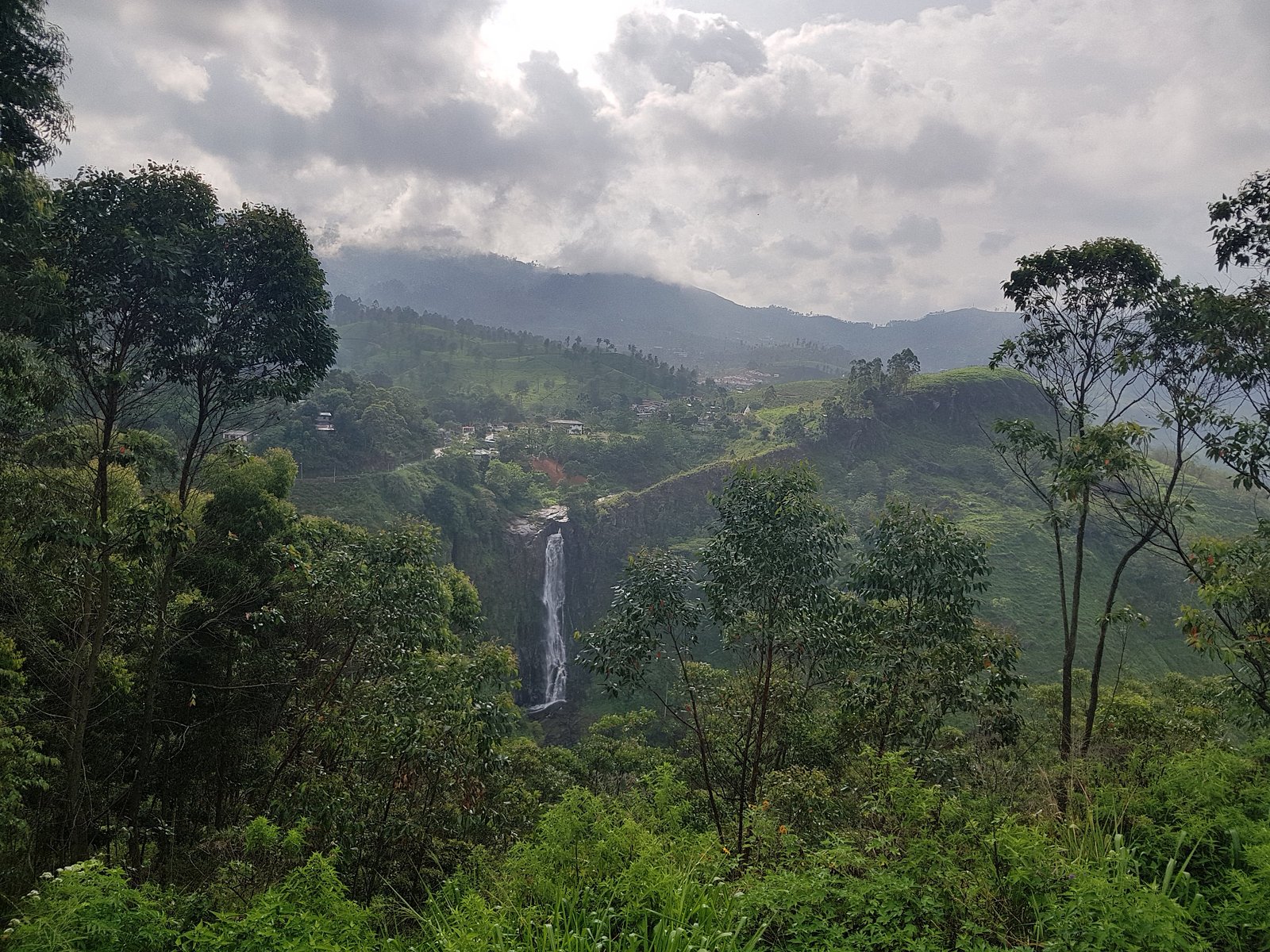
Frosst Creek Waterfall
By Armen Suny · Last verified Jun 2026
Difficulty
Easy
Trail Length
1.0 km
Trail Type
Out And Back
About Frosst Creek Waterfall
Frosst Creek Waterfall is a forested-creek cascade located near the Canada–US border in southern British Columbia (coordinates 49.0077, -122.0317). The waterfall appears to be on a small tributary (Frosst Creek) and is set in a heavily treed valley with mixed conifer and deciduous riparian vegetation. Published, maintained trail information for this specific waterfall is limited; visitation reports suggest a short, informal route and possibly social trails or rough access rather than a developed viewpoint. Water flow is typically highest in spring snowmelt and after heavy rains, and lower in late summer and early fall.
Why This Waterfall Exists
Frosst Creek Waterfall flows over Cultus Formation, a layered sedimentary rock layer deposited about 175-237 million years ago. These soft rocks erode readily, allowing the stream to carve a vertical drop into the landscape.
Nearby Falls Worth Visiting
McKay Creek Falls (30 m) lies 12.9 kilometres to the northwest. Also nearby: Liumchen Falls (16 m, 11.1 km).
Trail & Hike Details
Trail Description
Reports and regional context indicate the route to Frosst Creek Waterfall is likely an informal path or short bushwhack through mixed forest and riparian scrub. Trails may be rocky, rooty, and steep in places with limited or no trail markers. Expect a short approach from the nearest parking area (often under 2 miles one-way for similar small creeks), but because official trail data is lacking, the exact route, distances, and difficulty vary. Use GPS coordinates, a topographic map, or local trip reports to navigate.
What to Expect
Expect a small to medium cascade set in a narrow, forested ravine. There may be steep banks, slippery rock surfaces, and limited viewing platforms. Vegetation can obstruct views in late summer. Flow is seasonal, highest in spring and after storms, lower in late summer. There is likely little infrastructure (no guardrails, stairs, or interpretive signage). Cell service may be unreliable in valley bottoms or forested canyons.
Accessibility
The trail is short and relatively flat, but the surface may be uneven. Contact the managing agency for accessibility details.
Frequently Asked Questions
🐶 Are Dogs Allowed at Frosst Creek Waterfall?
❌ Dogs are not allowed
Are There Any Fees or Permits Required?
🆖 No fees required
🏊 Is There Swimming at Frosst Creek Waterfall?
❌ Swimming is not allowed
When to Visit
Late spring (snowmelt) and early summer for the most impressive flows. Fall can provide clearer views and cooler temperatures but flows may be reduced. Winter access may be hazardous due to snow, ice, or high runoff; only attempt with appropriate equipment and skills.
Seasonal Access
The best time to visit is Spring, Summer, Fall, and Winter. Check with the managing park or local authority for current conditions.
Safety Information
Hazards include: slippery rocks and riverbanks, steep or unstable edges, fast or cold water during high flows, limited or no trail signage, potential for private land or forestry activity, and seasonal insects. Always check weather and local conditions before visiting. If you are unfamiliar with the area, consider going with someone who knows the route or consulting recent trip reports. In winter, avalanche, ice, and deep snow can create significant hazards. If in doubt about route legality or safety, err on the side of caution and avoid crossing private land without permission.
Current Water Conditions
11.1 m³/s
Current discharge — how much water is flowing
Much lower than usual for this time of year
Based on 91 years of record
1.76 m
Water depth at gauge
7-Day Discharge Trend
What does this mean for your visit?
Flow is well below normal for this time of year, so the waterfall may be a trickle.
About This Gauge
This gauge is on a nearby waterway and may not reflect exact conditions at the falls.
7-Day Flow Outlook
Based on the WSC gauge CHILLIWACK RIVER AT VEDDER CROSSING (11 km away).
Today
Barely Flowing
11 m³/s
5/10Tomorrow
Barely Flowing
11 m³/s
4/10Tue
Barely Flowing
11 m³/s
4/10Wed
Barely Flowing
11 m³/s
4/10Thu
Barely Flowing
10 m³/s
4/10Fri
Barely Flowing
9.9 m³/s
4/10Sat
Barely Flowing
9.3 m³/s
4/10Best window: Today — barely flowing flow, sunny (trip score 5/10).
Best time of year: this gauge typically runs highest from late April to late July, peaking in June.
How we calculate this
This is a transparent outlook, not a precise forecast. We take the waterfall's current flow strength (how it ranks against its historical normal for today, from the nearest WSC stream gauge), carry that ranking forward along the gauge's seasonal curve, and nudge it for forecast rain. Confidence is highest for the next day or two and falls further out. Always check official conditions and your own judgment before visiting — high flows can be dangerous.
Know when to go.
Get a free email alert when waterfalls near Chilliwack hit peak flow. We only send when conditions are worth the trip — no weekly newsletters, no spam.
Weather Forecast
Location & Access
Getting There
The waterfall sits near the communities/places listed by the user (Maple Falls ~7.0 miles, Peaceful Valley ~7.7 miles, Kendall ~8.8 miles). Use the coordinates 49.0077, -122.0317 to locate the put-in. Access likely requires driving to a nearby pullout or small parking area on a secondary road and then hiking a short distance on unmarked or lightly used trails. Portions of the approach may be on rough forest roads, private property, or old logging spurs, confirm land status before crossing private land.
Get Directions on Google MapsParking
Expect limited parking: a roadside pullout or small informal lot may be present. Do not block gates, driveways, or forest-service access roads. If parking on a shoulder, leave plenty of room for other vehicles and emergency access. There may be no official signage or developed parking area.
Elevation
303 metres above sea level
Coordinates
49.007739° N, -122.031695° W
Visitor Tips & Gear
• Use the provided coordinates and offline maps/GPS; do not rely solely on cell service. • Wear sturdy, waterproof footwear and expect slippery rocks and muddy sections. • If the route crosses private land, obtain permission; many forested access roads in the region cross private or crown land. • Avoid getting too close to the edge of drops and avoid climbing on wet rocks. • Bring insect repellent (mosquitoes/blackflies can be abundant in spring/summer). • Leave no trace: pack out all trash and avoid disturbing vegetation. • Check recent trip reports or local land manager/forestry office for current access conditions and closures.
Where to Stay
Browse vacation cabins and private rentals nearby
Unique outdoor stays — tents, yurts, and treehouses
Rent a campervan or RV for your waterfall road trip
Some links are affiliate links. We may earn a commission at no extra cost to you.
Nearby Campground
Camp Linley
2.8 km away
Nearby Hot Springs
Hot springs near Chilliwack, British Columbia
Dorr Fumarole Field
Dorr Fumarole Field reaches 194 degrees at 8,168 feet elevation on Mount Baker's active volcanic slopes, producing superheated ...

Sherman Crater Fumaroles
Sherman Crater Fumaroles register 266 degrees Fahrenheit at 9,463 feet elevation within the active volcanic crater atop Mount B...
Baker Hot Spring
Baker Hot Spring emerges at 108 degrees Fahrenheit on US Forest Service land in Mt. Baker National Forest, flowing 59.5 degrees...
Looking for a soak after your hike? Explore more hot springs near Chilliwack, British Columbia on SoakingSprings.
Explore British Columbia springsAdditional Information
Nearby Attractions
Nearby places referenced by the user include Maple Falls, Peaceful Valley, and Kendall (distances provided). There may be other regional hiking trails, viewpoints, and forest roads in the surrounding area, consult local maps and recreation guides for additional attractions.
Wildlife
Typical southern coastal interior wildlife may be present: black bears, deer, small mammals, raptors, and a variety of songbirds. Take standard wildlife precautions: store food securely, give animals space, and follow local guidance for bear country if applicable.
Cities near Frosst Creek Waterfall
Nearby Waterfalls
Writing about Frosst Creek Waterfall? Embed this waterfall on your site for free.