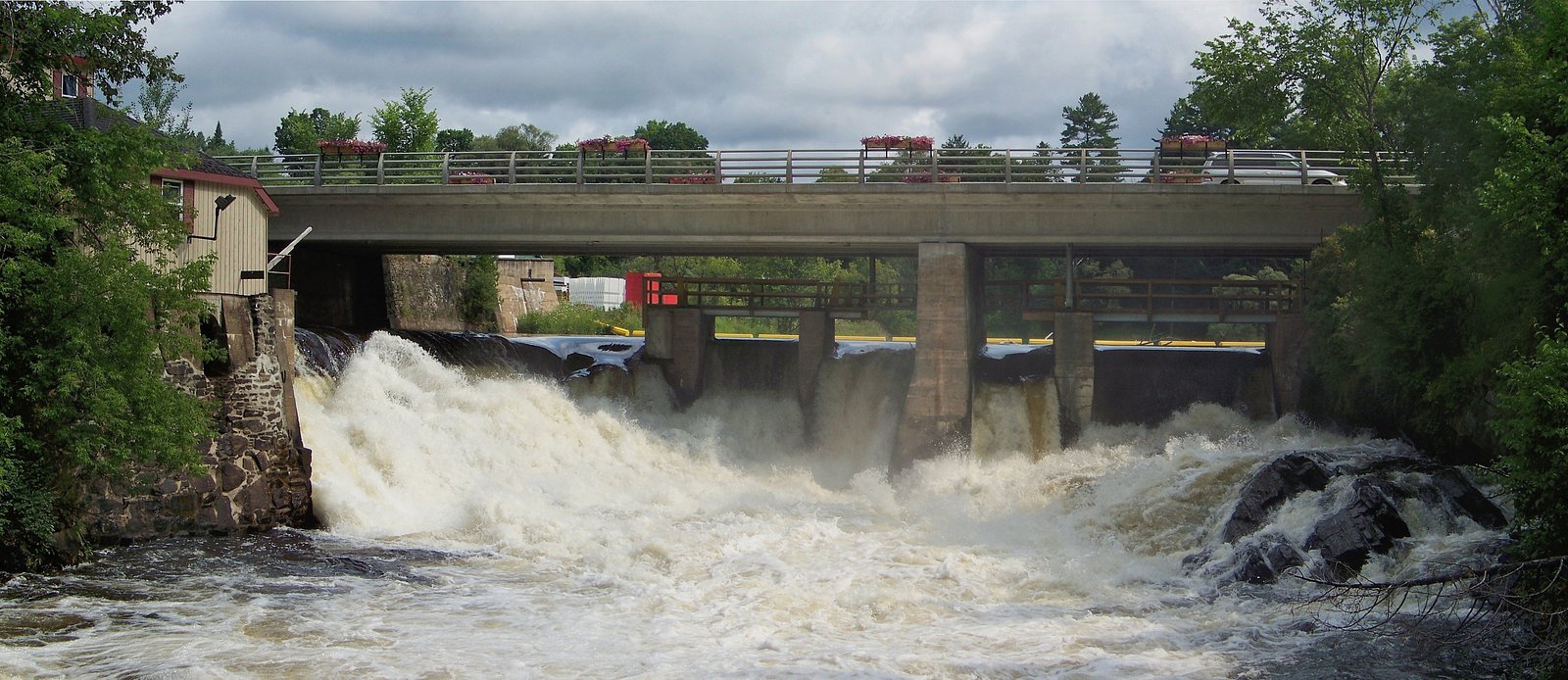
Matthiasville Falls
Ontario • 13 m
By Armen Suny · Last verified Jun 2026
Difficulty
Drive Up
Trail Length
0.2 km
Trail Type
Out And Back
About Matthiasville Falls
Matthiasville Falls is a small, likely locally known cascade near the coordinates 44.9934, -79.2017 in central Ontario. Reports are limited and the feature appears to be on a small tributary or creek in a mixed forest/rock setting. Water flow is likely highest in spring melt and after heavy rain, with lower flow in late summer. Precise published height and official park status are not confidently documented; visitors should verify land access before visiting.
The Setting
Matthiasville Falls sits at 290 metres in the foothills of Ontario. The falls drop 13 metres.
Why This Waterfall Exists
Matthiasville Falls flows over hard crystalline rock laid down over 1.4-1.6 billion years ago. These resistant rocks form a durable ledge that water cannot easily wear away, creating a 43-foot drop where softer material downstream has already eroded.
Nearby Falls Worth Visiting
Trethewey Falls (11 m) lies 5.5 kilometres to the west. Also nearby: Bracebridge Falls (10 m, 9.8 km) and Wilsons Falls (10 m, 11.3 km).
Trail & Hike Details
The Approach
No hiking required. Matthiasville Falls is accessible by vehicle with a roadside viewing area.
Trail Description
There is no widely published maintained trail description for Matthiasville Falls. Expect an informal or faint path from a roadside or small parking spot, potentially involving short bushwhack or rock scrambling to reach viewpoints. Trails (if present) may be narrow, uneven, and muddy after rain. Because authoritative trail routing is not documented, plan for off-trail navigation and verify property access.
What to Expect
The falls drop 13 metres over hard crystalline rock.
Accessibility
This waterfall is viewable from a vehicle-accessible area. No hiking is required.
Frequently Asked Questions
🐶 Are Dogs Allowed at Matthiasville Falls?
❌ Dogs are not allowed
Are There Any Fees or Permits Required?
🆖 No fees required
🏊 Is There Swimming at Matthiasville Falls?
❌ Swimming is not allowed
When to Visit
Spring (peak melt) for highest flows and early summer for fuller water levels. Fall offers good foliage color and lower visitor numbers. Late summer may have reduced flow. Winter visits are possible but can be hazardous due to ice and limited access; only attempt with appropriate winter gear and experience.
Seasonal Access
The best time to visit is Spring, Summer, and Fall. Winter access may be limited. Check with the managing park or local authority for current conditions.
Safety Information
Hazards: slippery rocks and wet banks, sudden changes in water flow after rain, steep or unstable banks, cold fast-moving water, ticks and biting insects, limited cell service, and potential private property boundaries. Do not climb on undermined banks or on wet rock slabs. Always tell someone your plans and expected return time. If unsure about land ownership or safe access routes, seek local guidance before visiting.
Current Water Conditions
1.7 m³/s
Current discharge — how much water is flowing
About average for this time of year
Based on 19 years of record
8.82 m
Water depth at gauge
7-Day Discharge Trend
What does this mean for your visit?
Flow is about average for this time of year.
About This Gauge
This gauge is on a nearby waterway and may not reflect exact conditions at the falls.
7-Day Flow Outlook
Based on the WSC gauge BLACK RIVER NEAR VANKOUGHNET (12 km away).
Today
Moderate
1.7 m³/s
6/10Tomorrow
Moderate
1.7 m³/s
6/10Tue
Moderate
1.8 m³/s
6/10Wed
Moderate
1.8 m³/s
6/10Thu
Moderate
1.8 m³/s
8/10Fri
Moderate
1.8 m³/s
6/10Sat
Moderate
1.6 m³/s
8/10Best window: Thu — moderate flow, cloudy (trip score 8/10).
Best time of year: this gauge typically runs highest from mid March to mid May, peaking in April.
How we calculate this
This is a transparent outlook, not a precise forecast. We take the waterfall's current flow strength (how it ranks against its historical normal for today, from the nearest WSC stream gauge), carry that ranking forward along the gauge's seasonal curve, and nudge it for forecast rain. Confidence is highest for the next day or two and falls further out. Always check official conditions and your own judgment before visiting — high flows can be dangerous.
Know when to go.
Get a free email alert when waterfalls near Orillia hit peak flow. We only send when conditions are worth the trip — no weekly newsletters, no spam.
Weather Forecast
Location & Access
Getting There
Approximate location: 44.9934, -79.2017. The falls lie in central Ontario, roughly 28.3 miles from Orillia, ~50.9 miles from Barrie, and ~51.8 miles from Parry Sound (distances provided for regional context). Access may require driving on local paved or gravel roads and then a short walk; specific trailheads or publicparking areas are not clearly documented. Visitors should use the coordinates with a reliable map app, and confirm whether the access route crosses private property.
Get Directions on Google MapsParking
Not well documented. Likely limited roadside or informal parking near a local access point. Parking may be informal and could be on or adjacent to private property, verify permitted parking and avoid blocking driveways.
Elevation
290 metres above sea level
Coordinates
44.993386° N, -79.201707° W
Visitor Tips & Gear
1) Confirm public access before visiting, some small waterfalls in the region are on or adjacent to private land. 2) Wear sturdy, waterproof footwear with good traction; rocks will be slippery. 3) Bring a map and download offline directions using the provided coordinates. 4) Avoid approaching the edge of banks or climbing on wet rocks. 5) Expect no facilities, pack out all trash. 6) Check local recent trip reports or community hiking resources for any updates on access or conditions.
Where to Stay
Browse vacation cabins and private rentals nearby
Unique outdoor stays — tents, yurts, and treehouses
Rent a campervan or RV for your waterfall road trip
Some links are affiliate links. We may earn a commission at no extra cost to you.
Nearby Campground
KOA Kampground
16.4 km away
Additional Information
Nearby Attractions
Regional points of interest include the Orillia area, Georgian Bay/Muskoka region attractions, provincial parks and inland lakes in the broader area. Exact nearby named attractions depend on the final chosen route and access point.
Wildlife
Typical central Ontario wildlife may be present: white-tailed deer, raccoons, foxes, small mammals, a variety of songbirds, and black bears in some areas of the region. Take standard precautions for wildlife, store food securely, and be aware of ticks in warmer months.
Cities near Matthiasville Falls
Nearby Waterfalls
Writing about Matthiasville Falls? Embed this waterfall on your site for free.