Difficulty
Easy
Trail Length
0.5 km
Trail Type
Out And Back
About Marsh's Falls
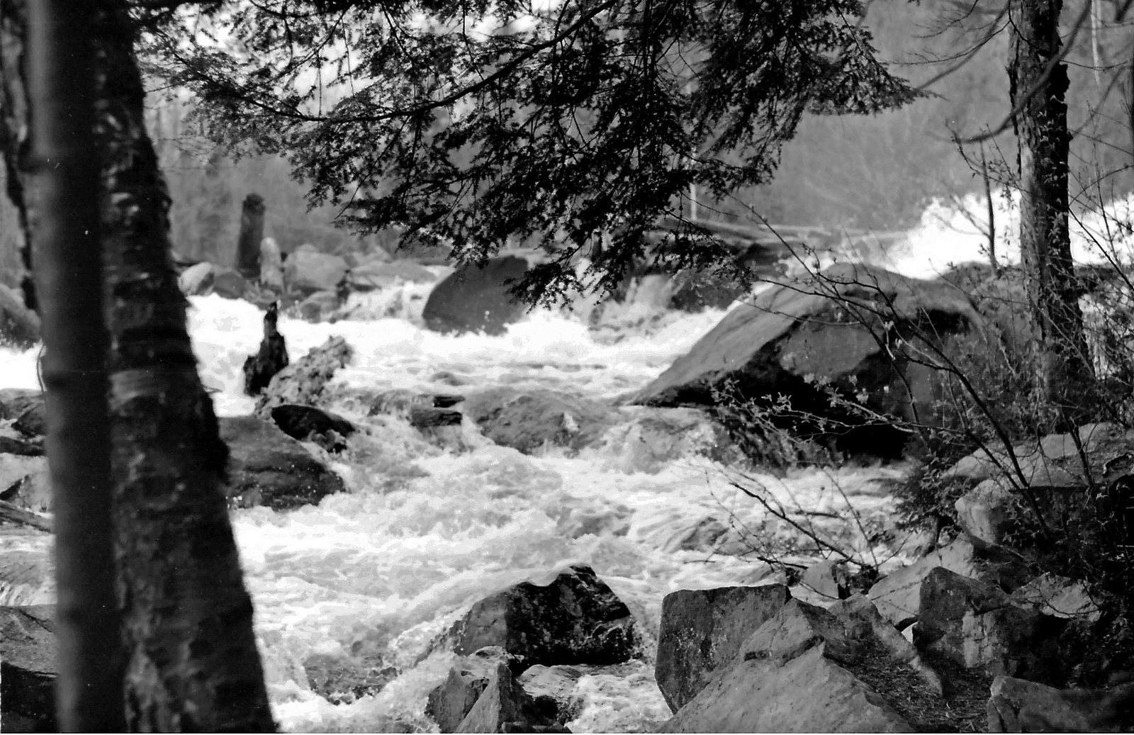
Marsh's Falls is a small, low-volume cascade located in central Ontario (coords: 45.3119, -78.9902). It appears to be a modest waterfall on a small creek or river and is best experienced as a short visit rather than a major destination. Flow and appearance are highly seasonal, typically strongest in spring and after heavy rain and much reduced in late summer. Public access details appear limited and some viewpoints may be from a roadside pullout or a short, unmarked path. Verify access before visiting, as sections of the stream and shoreline may be on private land.
Why This Waterfall Exists
Marsh's Falls flows over hard crystalline rock, primarily gneiss, laid down over 1.0-2.5 billion years ago. These resistant rocks form a durable ledge that water cannot easily wear away, creating the falls where softer material downstream has already eroded.
Trail & Hike Details
Trail Description
Where access exists, approaches to the falls are likely short, unmarked, and over uneven ground. Expect a simple footpath or desire-line through forest or along a streambank rather than a maintained trail. Surfaces may be muddy, rooty, and slippery near the water. There may be minimal or no trail infrastructure (no boardwalks, railings, or defined viewpoints).
What to Expect
A small, natural cascade rather than a high-volume or tall waterfall. Seasonal variability: higher flows in spring and after rainfall, low flows in late summer. Limited amenities, no visitor facilities, bathrooms, or signage typically present. Vegetation may be thick in summer and black flies/mosquitoes and ticks can be abundant. Views may be restricted to a single vantage point; avoid approaching the waterline if banks are unstable.
Accessibility
The trail is short and relatively flat, but the surface may be uneven. Contact the managing agency for accessibility details.
Frequently Asked Questions
🐶 Are Dogs Allowed at Marsh's Falls?
❌ Dogs are not allowed
Are There Any Fees or Permits Required?
🆖 No fees required
🏊 Is There Swimming at Marsh's Falls?
❌ Swimming is not allowed
When to Visit
Spring (high flow) and fall (lower crowds and good foliage). Winter can offer interesting ice formations but may be hazardous and access may be limited by snow/ice. Summer provides easy access but lower flows and more insects.
Seasonal Access
The best time to visit is Spring, Summer, Fall, and Winter. Check with the managing park or local authority for current conditions.
Safety Information
Exercise caution around wet rocks and banks, they are slippery and may be unstable. Flow can increase suddenly after storms. Cell coverage may be limited; tell someone your plans and estimated return time. Respect private property boundaries; trespassing can be dangerous and illegal. Be aware of insects and ticks; take appropriate precautions. In winter, ice and snow increase hazards, do not assume frozen water is safe to walk on.
7-Day Flow Outlook
Based on the WSC gauge OXTONGUE RIVER NEAR DWIGHT (0 km away).
Best time of year: this gauge typically runs highest from late March to late May, peaking in April.
How we calculate this
This is a transparent outlook, not a precise forecast. We take the waterfall's current flow strength (how it ranks against its historical normal for today, from the nearest WSC stream gauge), carry that ranking forward along the gauge's seasonal curve, and nudge it for forecast rain. Confidence is highest for the next day or two and falls further out. Always check official conditions and your own judgment before visiting — high flows can be dangerous.
Know when to go.
Get a free email alert when waterfalls near Orillia hit peak flow. We only send when conditions are worth the trip — no weekly newsletters, no spam.
Weather Forecast
Location & Access
Getting There
Coordinates: 45.3119, -78.9902. Use a reliable mapping app to navigate to these coordinates. The site is in rural Ontario; nearest notable community referenced: Orillia (user-provided approx. 52.8 miles). Expect local secondary roads and limited signage. Confirm ownership/status of the land at the coordinates before parking or crossing private property.
Get Directions on Google MapsParking
Parking is likely limited to a roadside pullout or informal shoulder parking. There may be no formal parking lot. Park well off the travel lane, follow local signage and avoid blocking private driveways. If you find a small parking area, it may be unpaved.
Elevation
318 metres above sea level
Coordinates
45.311876° N, -78.990190° W
Visitor Tips & Gear
1) Confirm land ownership and access before visiting; some areas in rural Ontario are private. 2) Wear sturdy, waterproof footwear with good traction, rocks and banks are slippery. 3) Bring insect repellent and check for ticks after visiting. 4) Park safely off the roadway and avoid blocking driveways. 5) Leave no trace: pack out trash and avoid disturbing vegetation. 6) Be cautious of unstable banks and currents; do not climb on wet rock faces.
Where to Stay
Browse vacation cabins and private rentals nearby
Unique outdoor stays — tents, yurts, and treehouses
Rent a campervan or RV for your waterfall road trip
Some links are affiliate links. We may earn a commission at no extra cost to you.
Nearby Campground
Lions Camp Dorset
15.3 km away
Additional Information
Nearby Attractions
Nearest referenced town: Orillia (user-provided approx. 52.8 miles). The broader area of central Ontario offers lakes, provincial parks, and other small waterfalls, check local tourism resources for confirmed nearby attractions.
Wildlife
Typical rural Ontario wildlife may be present: white-tailed deer, beaver, waterfowl, various songbirds, and small mammals. Insect hazards: black flies, mosquitoes, and ticks (Lyme disease-carrying ticks can be present).
Cities near Marsh's Falls
Nearby Waterfalls
Writing about Marsh's Falls? Embed this waterfall on your site for free.