About Les grosses chutes à Tommy
Les grosses chutes à Tommy is a forested, remote waterfall on the Gaspé Peninsula in Quebec (coordinates 48.4049, -64.9593), located roughly 41 miles (about 66 km) from the town of Gaspé. The falls sit in a rugged, wooded landscape typical of the region and are most often visited by people seeking off-the-beaten-path natural features. Precise published information on the falls (official signage, maintained trail, or measured height) appears to be limited; access may involve unmarked or lightly used forest trails and short scrambles over rock and roots. Flow varies seasonally (higher in spring melt and after heavy rain).
Why This Waterfall Exists
Les grosses chutes à Tommy flows over layered sedimentary rock laid down about 419-485 million years ago. Over time, the stream has worn through these layers at different rates, creating the step that forms the waterfall.
Trail & Hike Details
Trail Description
Reported approaches appear to be informal: a short unmarked walking route or scramble from an access point or roadside pullout through mixed forest to the stream and falls. Trails may be faint, muddy, and include roots and rocks. Routefinding skills may be required. There is likely limited or no maintained infrastructure (stairs, handrails, viewing platforms).
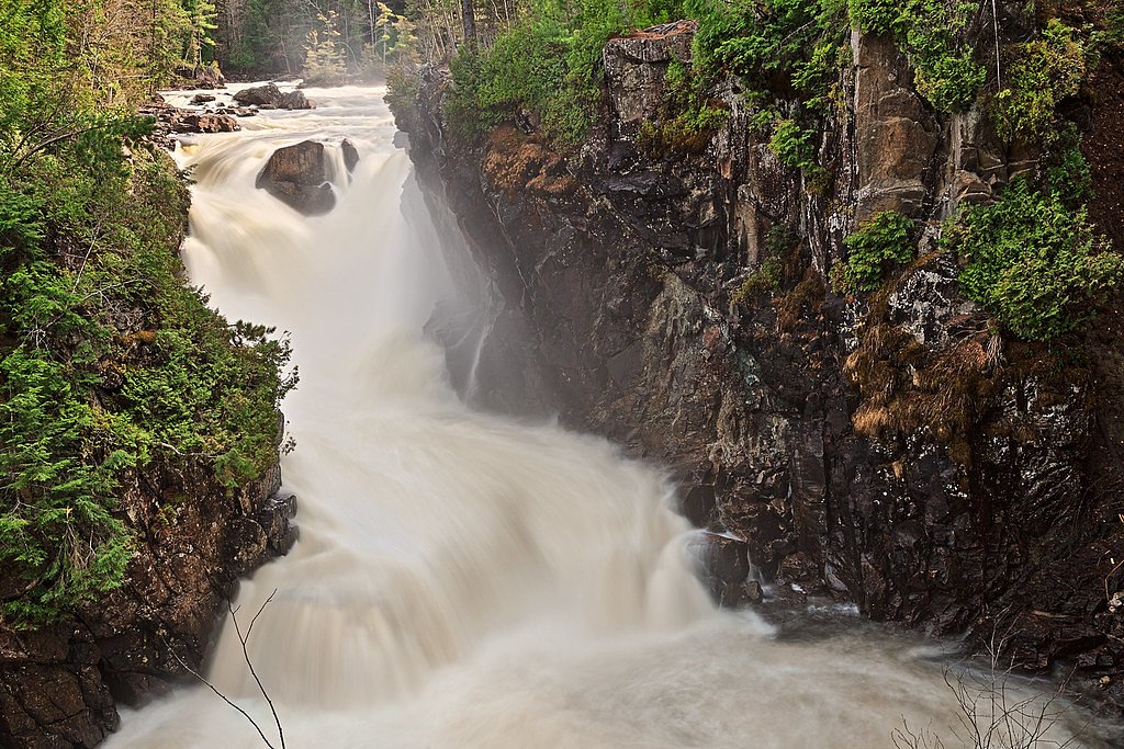
What to Expect
A relatively remote, natural waterfall setting with little infrastructure. Expect uneven, potentially wet and slippery rock, fallen trees, and dense forest vegetation. Water flow is seasonal, typically strongest in spring and after heavy rain. Little or no cell reception in parts of the Gaspé interior is possible. No formal safety barriers or facilities are expected.
Accessibility
Not accessible for visitors with limited mobility. Expect uneven, rocky, and potentially steep terrain with no formal accessibility features.
Frequently Asked Questions
🐶 Are Dogs Allowed at Les grosses chutes à Tommy?
❌ Dogs are not allowed
Are There Any Fees or Permits Required?
🆖 No fees required
🏊 Is There Swimming at Les grosses chutes à Tommy?
❌ Swimming is not allowed
When to Visit
Spring (snowmelt) for highest flows; late spring through early fall for easier access and warmer weather; fall for foliage. Winter may offer frozen/icy scenery but can present difficult road and trail conditions, only attempt with winter hiking/ice-scrambling experience and appropriate gear.
Seasonal Access
The best time to visit is Spring, Summer, Fall, and Winter. Check with the managing park or local authority for current conditions.
Safety Information
Exercise caution: rocks and ledges near falls are slippery; currents can be deceptively strong. There are likely no guardrails or signage. Limited cell coverage and remote location can delay emergency response, tell someone your plan and expected return time. Watch for unstable banks, loose rock, and rapid water level changes after rain. In winter, ice can be unstable and hypothermia risk increases, specialized winter equipment and experience required.
7-Day Flow Outlook
Based on the WSC gauge YORK (RIVIERE) A 1,4 KM EN AVAL DU RUISSEAU DINNER ISLAND (45 km away).
Best time of year: this gauge typically runs highest from mid April to late June, peaking in May.
How we calculate this
This is a transparent outlook, not a precise forecast. We take the waterfall's current flow strength (how it ranks against its historical normal for today, from the nearest WSC stream gauge), carry that ranking forward along the gauge's seasonal curve, and nudge it for forecast rain. Confidence is highest for the next day or two and falls further out. Always check official conditions and your own judgment before visiting — high flows can be dangerous.
Know when to go.
Get a free email alert when waterfalls near Gaspé hit peak flow. We only send when conditions are worth the trip — no weekly newsletters, no spam.
Weather Forecast
Location & Access
Getting There
The falls are located in the general Gaspé region (coordinates provided). Reaching the site typically requires driving rural or forest roads from Gaspé and then following an unpaved access road or informal path. There may be no formal trailhead signage; visitors should plan for limited or no services and possible unmarked routing. Use a detailed map, GPS coordinates, or local guide information before traveling.
Get Directions on Google MapsParking
No confirmed formal parking lot is known. Parking may be roadside or a small informal pullout on an unpaved access road. Park well off the travel lane, avoid blocking gates or private access, and expect no facilities (no restrooms or trash service).
Elevation
112 metres above sea level
Coordinates
48.404875° N, -64.959273° W
Visitor Tips & Gear
• Wear sturdy, grippy footwear; expect wet and slippery rocks. • Use map/GPS and bring a downloaded offline map, routes may be unmarked. • Bring insect repellent (blackflies/mosquitoes can be heavy in spring/summer). • Pack out all trash and follow Leave No Trace principles. • Supervise children closely around water and cliffs. • Check local road and weather conditions before travel; some forest roads may require high-clearance or 4x4 vehicles. • If unsure about access or safety, consult local visitor centers or experienced local hikers.
Where to Stay
Browse vacation cabins and private rentals nearby
Unique outdoor stays — tents, yurts, and treehouses
Rent a campervan or RV for your waterfall road trip
Some links are affiliate links. We may earn a commission at no extra cost to you.
Nearby Campground
Camping de Port-Daniel
17.3 km away
Additional Information
Nearby Attractions
The broader Gaspé Peninsula offers many attractions: Forillon National Park, Percé Rock and Île Bonaventure, coastal viewpoints, and local hiking routes. Consult regional tourism resources for up-to-date information on attractions and services near Gaspé.
Wildlife
Typical Gaspésie fauna may include moose, white-tailed deer, foxes, various bird species (including raptors and seabirds closer to the coast), and potentially black bears. Take standard wildlife precautions: store food securely, keep distance, and do not approach animals.
Cities near Les grosses chutes à Tommy
Nearby Waterfalls
Writing about Les grosses chutes à Tommy? Embed this waterfall on your site for free.