About Chute du Taureau
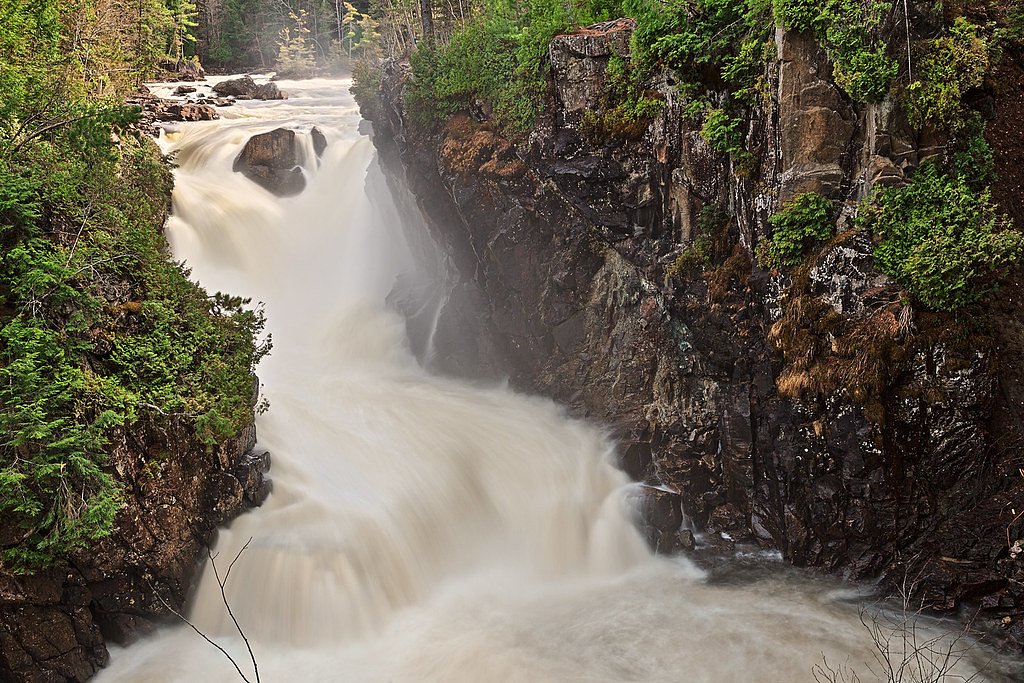
Chute du Taureau ("Bull Falls") is a natural waterfall on the Gaspé Peninsula in Quebec near the town of Gaspé (the site is roughly 40.5 miles from Gaspé). Located at approximately 48.3906, -64.9283, the falls sit in a rocky, forested setting and are most notable for seasonally variable flow, high in spring and after heavy rain, lower in late summer. Exact published information about the drop and formal facilities is limited; access appears to be via local roads and an informal trail. Visitors should treat specific trail features (length, steepness, boardwalks) as unconfirmed and check local sources before visiting.
Why This Waterfall Exists
Chute du Taureau flows over layered sedimentary rock laid down about 419-485 million years ago. Over time, the stream has worn through these layers at different rates, creating the step that forms the waterfall.
Trail & Hike Details
Trail Description
Published, detailed trail descriptions are limited. Reports indicate the approach may be an informal footpath from a roadside parking area and could include uneven, rocky, or muddy surfaces and short steep sections near the gorge. Expect minimal developed infrastructure (few or no handrails, viewing platforms or signage). Because official trail data is scarce, assume variable footing and limited trail maintenance.
What to Expect
A forested setting with a rocky gorge and a waterfall whose flow varies with season and recent precipitation. Expect natural footing (roots, rocks), potential exposed cliff edges, and limited or no restroom or potable water facilities. Wildlife typical of the Gaspé region (songbirds, small mammals, and possibly moose or black bear) may be present. Views can be excellent in spring (high flow) and fall (foliage). Winter conditions can form ice and snow features but are also more hazardous.
Accessibility
No confirmed accessible infrastructure. Expect uneven, rocky, and potentially steep terrain near the falls; not suitable for wheelchairs or strollers without assistance.
Frequently Asked Questions
🐶 Are Dogs Allowed at Chute du Taureau?
❌ Dogs are not allowed
Are There Any Fees or Permits Required?
🆖 No fees required
🏊 Is There Swimming at Chute du Taureau?
❌ Swimming is not allowed
When to Visit
Late spring for the highest water flow and dramatic appearance; early fall for foliage and comfortable hiking temperatures. Summer offers the easiest access and warmer conditions but may have lower flows. Winter can present striking frozen scenery but requires winter gear and experience with icy, remote terrain.
Seasonal Access
The best time to visit is Spring, Summer, Fall, and Winter. Check with the managing park or local authority for current conditions.
Safety Information
• Slippery, wet, and unstable rocks near the falls present fall hazards. • Strong currents and hydraulic features near waterfall bases can be deadly; avoid entering fast water. • Remote or informal access means help may be far away, carry a basic first-aid kit and tell someone your plans. • Winter travel requires winter hiking experience and appropriate traction/gear; ice can make cliffs and paths hazardous. • Check local road and weather conditions before traveling and follow posted signs or landowner instructions.
7-Day Flow Outlook
Based on the WSC gauge YORK (RIVIERE) A 1,4 KM EN AVAL DU RUISSEAU DINNER ISLAND (46 km away).
Best time of year: this gauge typically runs highest from mid April to late June, peaking in May.
How we calculate this
This is a transparent outlook, not a precise forecast. We take the waterfall's current flow strength (how it ranks against its historical normal for today, from the nearest WSC stream gauge), carry that ranking forward along the gauge's seasonal curve, and nudge it for forecast rain. Confidence is highest for the next day or two and falls further out. Always check official conditions and your own judgment before visiting — high flows can be dangerous.
Know when to go.
Get a free email alert when waterfalls near Gaspé hit peak flow. We only send when conditions are worth the trip — no weekly newsletters, no spam.
Weather Forecast
Location & Access
Getting There
The coordinates for Chute du Taureau are approximately 48.3906, -64.9283. From Gaspé expect a drive of roughly 40–45 miles (about 65–73 km) depending on route. Access is typically via secondary and forestry roads; final approach may be on a short unpaved spur or logging road. Cell service may be intermittent in areas. Confirm current road conditions and access with local tourist offices or municipal sites before traveling.
Get Directions on Google MapsParking
There may be a small informal parking or pullout near the trailhead; no large paved lot or staffed parking is documented. Parking may be limited and could be on gravel/shoulder. Visitors should avoid blocking gates or private driveways.
Elevation
71 metres above sea level
Coordinates
48.390599° N, -64.928314° W
Visitor Tips & Gear
• Wear sturdy, closed-toe hiking shoes with good tread; rocks near the water can be slippery. • Check weather and recent visitor reports before going, water levels and road conditions can change quickly. • Bring layers; coastal Gaspé weather can be cool and changeable. • Leave no trace: pack out garbage and avoid trampling vegetation near the falls. • If parking is informal, avoid blocking gates or private property and follow local signs. • Cell service may be spotty, download maps or save coordinates beforehand.
Where to Stay
Browse vacation cabins and private rentals nearby
Unique outdoor stays — tents, yurts, and treehouses
Rent a campervan or RV for your waterfall road trip
Some links are affiliate links. We may earn a commission at no extra cost to you.
Nearby Campground
Camping de Port-Daniel
15.9 km away
Additional Information
Nearby Attractions
The Gaspé Peninsula offers many attractions: coastal vistas, regional parks, and well-known sites such as Forillon National Park and Percé Rock (these are regional examples; distances and driving times vary). Check local tourism resources for up-to-date lists and directions.
Wildlife
Typical regional wildlife may include black bear, moose, white-tailed deer, small mammals, and a variety of birds. Be bear-aware in season and store food securely.
Cities near Chute du Taureau
Nearby Waterfalls
Writing about Chute du Taureau? Embed this waterfall on your site for free.