Difficulty
Moderate
Trail Length
1.0 km
Trail Type
Loop
Elevation Gain
90 m
About Big Falls Brook
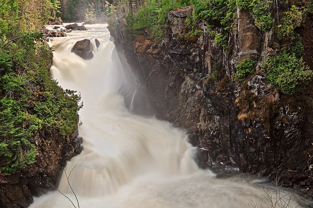
Big Falls Brook is a small brook-side waterfall feature on the Gaspé Peninsula in eastern Quebec, located near the coordinates 48.3915, -64.8356 and roughly 36.5 miles from the town of Gaspé. Sources for exact official information are limited; the feature appears to be a modest cascade in a mixed boreal/Acadian forest setting. Water flow is seasonal and is typically highest in spring runoff and after heavy rain. Exact measured height and official facility details are not readily documented.
Why This Waterfall Exists
Big Falls Brook flows over layered sedimentary rock laid down about 419-485 million years ago. Over time, the stream has worn through these layers at different rates, creating the step that forms the waterfall.
Trail & Hike Details
The Approach
The moderate 1.0-km loop trail gains 90 metres of elevation on the way to the falls.
Trail Description
There is no widely published, maintained trail description for Big Falls Brook waterfall. Approaches are likely on informal footpaths or through forested terrain beside the brook. Trails (if present) may be unmarked, uneven, muddy, and involve short steep sections to reach viewpoints. Route-finding skills may be required.
What to Expect
A modest brook cascade set in mixed forest typical of the Gaspé Peninsula. Expect variable flow, highest in spring and after rains, lower in late summer. Trail conditions may include roots, loose rocks, mud, and wet surfaces near the falls. Little to no infrastructure (railings, viewing platforms, restrooms). Limited or intermittent cell service in remote sections. Wildlife in the area may include moose, black bear, small mammals, and a variety of bird species.
Accessibility
The trail is not wheelchair accessible. Uneven terrain and elevation changes require steady footing.
Frequently Asked Questions
🐶 Are Dogs Allowed at Big Falls Brook?
❌ Dogs are not allowed
Are There Any Fees or Permits Required?
🆖 No fees required
🏊 Is There Swimming at Big Falls Brook?
❌ Swimming is not allowed
When to Visit
Late spring (snowmelt/peak runoff) for the strongest flow and after rainy periods in other seasons. Early fall offers cooler temperatures and fall foliage. Avoid winter unless you are prepared for icy, cold conditions and potential avalanche/ice hazards on steep slopes; winter conditions can also make access roads impassable.
Seasonal Access
The best time to visit is Spring, Summer, and Fall. Winter access may be limited. Check with the managing park or local authority for current conditions.
Safety Information
Hazards may include slippery wet rock near the falls, unstable banks, sudden changes in water flow after rain, limited cell service, and encounters with wildlife (including black bears). Use caution near edges, avoid climbing on wet rocks, wear appropriate footwear, and do not approach the water during high flows. Check local weather and road conditions before traveling. If you are unfamiliar with the area, consider going with someone who knows local trails or hiring a local guide.
7-Day Flow Outlook
Based on the WSC gauge YORK (RIVIERE) A 1,4 KM EN AVAL DU RUISSEAU DINNER ISLAND (47 km away).
Best time of year: this gauge typically runs highest from mid April to late June, peaking in May.
How we calculate this
This is a transparent outlook, not a precise forecast. We take the waterfall's current flow strength (how it ranks against its historical normal for today, from the nearest WSC stream gauge), carry that ranking forward along the gauge's seasonal curve, and nudge it for forecast rain. Confidence is highest for the next day or two and falls further out. Always check official conditions and your own judgment before visiting — high flows can be dangerous.
Know when to go.
Get a free email alert when waterfalls near Gaspé hit peak flow. We only send when conditions are worth the trip — no weekly newsletters, no spam.
Weather Forecast
Location & Access
Getting There
The waterfall is located on Big Falls Brook in the Gaspé region. The coordinates (48.3915, -64.8356) are the best guide; expect access via secondary or forest roads branching from regional highways. Exact public trailheads and official parking areas are not well-documented, visitors should plan to use detailed maps or GPS and verify local road conditions. A high-clearance or all-wheel-drive vehicle may be useful for unpaved approaches. Check with local municipal or park authorities for last-mile access information before traveling.
Get Directions on Google MapsParking
Parking is likely informal (pull-off or small gravel clearing) rather than a developed lot. Expect limited or no facilities. Park legally and avoid blocking forestry/landowner access.
Elevation
58 metres above sea level
Coordinates
48.391514° N, -64.835553° W
Visitor Tips & Gear
• Use sturdy, waterproof footwear with good traction. • Bring a map or GPS and download maps for offline use; coordinates are 48.3915, -64.8356. • Expect no facilities; carry out all trash. • Watch for slippery rocks and unstable edges; do not stand above the falls on wet rock. • Check local road conditions and weather before heading out; unpaved access roads can be muddy or washed out. • If visiting during black bear or hunting seasons, take appropriate precautions (store food securely, wear bright clothing). • Verify access rules with local authorities or land managers, some nearby areas may be on private or managed forest lands.
As an Amazon Associate, we earn from qualifying purchases.
With 1.0 km and 90 m of elevation gain, sturdy boots and trekking poles will help on this moderate trail. Sun exposure on the trail makes good sun protection a must in summer.

Columbia Watertight II Rain Jacket
Packs into its own pocket, seam-sealed, and keeps you dry from spray and surprise rain.

Earth Pak Waterproof Dry Bag
Keeps your phone and gear dry when waterfall mist soaks everything else.

Waterproof Phone Pouch (AiRunTech)
Cheap insurance — take photos right next to the falls without killing your phone.

Timberland Euro Sprint Mid Waterproof
Trusted waterproof boot with premium leather and grippy rubber sole — reliable on rocky, wet trails.

TrailBuddy Trekking Poles
Lightweight aluminum, cork grips, and flip-locks that actually hold — a best-seller for good reason.

Polarized Sunglasses (Knockaround)
Cuts glare off the water so you actually see the falls — and your photos turn out better too.
Where to Stay
Browse vacation cabins and private rentals nearby
Unique outdoor stays — tents, yurts, and treehouses
Rent a campervan or RV for your waterfall road trip
Some links are affiliate links. We may earn a commission at no extra cost to you.
Nearby Campground
Camping du Parc du Bourg de Pabos
12.5 km away
Additional Information
Nearby Attractions
General attractions on the Gaspé Peninsula include Parc national de la Gaspésie, Forillon National Park, Percé and Percé Rock, and coastal viewpoints. Distances and exact proximity vary, consult regional maps for planning multi-stop trips.
Wildlife
Potential wildlife includes moose, black bear, white-tailed deer, beaver, foxes, and numerous bird species. Take standard wildlife precautions (keep distance, store food securely).
Cities near Big Falls Brook
Nearby Waterfalls
Writing about Big Falls Brook? Embed this waterfall on your site for free.