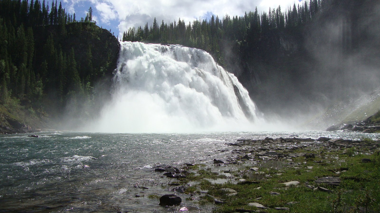
Kinuseo Falls
British Columbia • Monkman Park • 60 m
By Armen Suny · Last verified Jun 2026
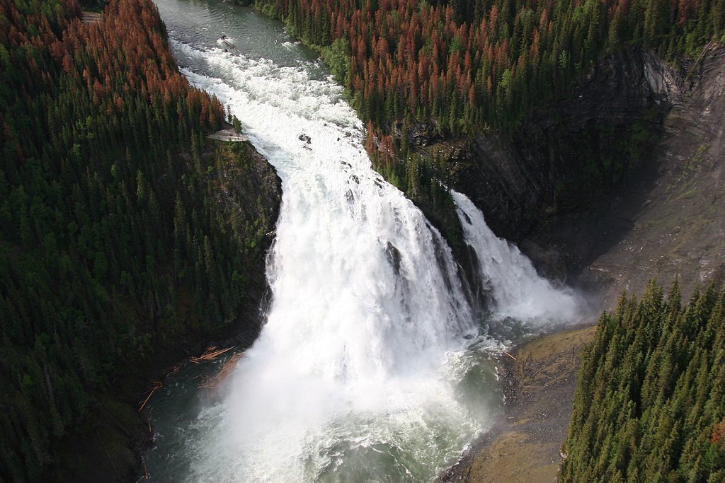

Photo Credits (3)
Difficulty
Moderate
Trail Length
2.9 km
Trail Type
Out And Back
Elevation Gain
135 m
About Kinuseo Falls
Kinuseo Falls is a waterfall on the Murray River, which flows through the northern tip of Monkman Provincial Park in the Northern Rockies of British Columbia, Canada. The falls are located south of the community of Tumbler Ridge and northeast of the city of Prince George, though there is no road access from the Prince George side of the Rocky Mountains.
The Setting
Kinuseo Falls sits at 830 metres within Monkman Park, in the hills of British Columbia. At 60 metres, it is among the taller waterfalls in British Columbia.
Why This Waterfall Exists
Kinuseo Falls flows over Sulphur Mountain Formation, a layered sedimentary rock layer deposited about 201-237 million years ago. These soft rocks erode readily, allowing the stream to carve a 197-foot drop into the landscape.
Nearby Falls Worth Visiting
Babcock Falls (8 m) lies 20.1 kilometres to the northeast.
Trail & Hike Details
The Approach
The moderate 2.9-km out-and-back trail gains 135 metres of elevation on the way to the falls.
Trail Description
A short, well-marked trail from the parking/day-use area leads to a viewpoint and boardwalk overlooking Kinuseo Falls. The route is short and family-friendly with some stairs and uneven ground near the overlook. The viewpoint provides a broad view of the falls and the canyon; there are interpretive signs at the site. Longer backcountry routes exist in Monkman Provincial Park but the primary falls viewpoint is a short walk.
What to Expect
The falls plunge 60 metres over soft fine-grained rock.
Accessibility
The trail is not wheelchair accessible. Uneven terrain and elevation changes require steady footing.
Frequently Asked Questions
🐶 Are Dogs Allowed at Kinuseo Falls?
❌ Dogs are not allowed
Are There Any Fees or Permits Required?
🆖 No fees required
🏊 Is There Swimming at Kinuseo Falls?
❌ Swimming is not allowed
When to Visit
Late spring to early summer for the fullest flow (snowmelt). Summer for easiest access and milder weather. Fall for foliage and fewer visitors. Winter access may be limited by snow and ice and the trail/viewpoint can be hazardous.
Seasonal Access
The best time to visit is Spring, Summer, Fall, and Winter. Check with Monkman Park for current conditions.
Safety Information
Stay on designated trails and viewing platforms. Edges near the canyon can be steep and slippery; avoid getting too close to unprotected edges. Water is cold and currents strong, do not attempt to swim near the falls. Expect limited cell service and bring supplies for remote-area travel. Be prepared for rapidly changing weather and insects in summer. Carry and know how to use bear spray if traveling beyond developed day-use areas.
Current Water Conditions
Based on a Water Survey of Canada gauge 32.9 km away
111.0 m³/s
Current discharge — how much water is flowing
About average for this time of year
Based on 48 years of record
1.79 m
Water depth at gauge
7-Day Discharge Trend
What does this mean for your visit?
Flow is about average for this time of year.
About This Gauge
This gauge is on a regional waterway. Conditions at the falls may differ, especially after local rain.
7-Day Flow Outlook
Based on the WSC gauge MURRAY RIVER ABOVE WOLVERINE RIVER (33 km away).
Today
Strong
127 m³/s
7/10Tomorrow
Strong
133 m³/s
8/10Tue
Moderate
117 m³/s
8/10Wed
Moderate
106 m³/s
8/10Thu
Moderate
108 m³/s
9/10Fri
Moderate
104 m³/s
8/10Sat
Strong
116 m³/s
8/10Best window: Thu — moderate flow, mainly sunny (trip score 9/10).
Best time of year: this gauge typically runs highest from early May to late July, peaking in June.
How we calculate this
This is a transparent outlook, not a precise forecast. We take the waterfall's current flow strength (how it ranks against its historical normal for today, from the nearest WSC stream gauge), carry that ranking forward along the gauge's seasonal curve, and nudge it for forecast rain. Confidence is highest for the next day or two and falls further out. Always check official conditions and your own judgment before visiting — high flows can be dangerous.
Weather Forecast
Location & Access
Getting There
Kinuseo Falls is in Monkman Provincial Park near Tumbler Ridge, BC. From Tumbler Ridge follow the signed access roads toward Monkman Provincial Park/Kinuseo Falls (the route includes secondary or gravel roads). The falls are reached from the Kinuseo Falls day-use/parking area; follow onsite signs and established trail to the viewpoint. Road and surface conditions may vary and the final approach may be on gravel or unsurfaced roads, check local park or municipal sources for up-to-date access information before travel.
Get Directions on Google MapsParking
Marked day-use parking near the Kinuseo Falls trailhead. The lot is relatively small and may fill on busy summer days; park responsibly and use designated spaces. In winter or poor weather the lot or approach road may be snow-covered or rough.
Elevation
830 metres above sea level
Coordinates
54.783979° N, -121.191076° W
Land Management
Managed by Government of British Columbia
Visitor Tips & Gear
Arrive early in summer to secure parking. Wear sturdy, non-slip footwear, boardwalks and viewpoint edges can be wet. Bring insect repellent in late spring/summer. Stay on designated trails and viewing platforms; edges can be unstable and slippery. Check road and weather conditions before travel; some approaches may be gravel and rough. Carry water and basic first-aid supplies. Practice bear-aware behavior in backcountry areas and carry bear spray where appropriate.
As an Amazon Associate, we earn from qualifying purchases.
With 2.9 km and 135 m of elevation gain, sturdy boots and trekking poles will help on this moderate trail. Icy conditions are common in winter — traction cleats are a smart addition.

Columbia Watertight II Rain Jacket
Packs into its own pocket, seam-sealed, and keeps you dry from spray and surprise rain.

Polarized Sunglasses (Knockaround)
Cuts glare off the water so you actually see the falls — and your photos turn out better too.

Earth Pak Waterproof Dry Bag
Keeps your phone and gear dry when waterfall mist soaks everything else.

Waterproof Phone Pouch (AiRunTech)
Cheap insurance — take photos right next to the falls without killing your phone.

Timberland Euro Sprint Mid Waterproof
Trusted waterproof boot with premium leather and grippy rubber sole — reliable on rocky, wet trails.

TrailBuddy Trekking Poles
Lightweight aluminum, cork grips, and flip-locks that actually hold — a best-seller for good reason.
Where to Stay
Browse vacation cabins and private rentals nearby
Unique outdoor stays — tents, yurts, and treehouses
Rent a campervan or RV for your waterfall road trip
Some links are affiliate links. We may earn a commission at no extra cost to you.
Nearby Campground
Kinuseo Falls Campground
2.4 km away
Additional Information
Nearby Attractions
Monkman Provincial Park trails and backcountry, Kinuseo Falls campground/day-use area, the town of Tumbler Ridge and its outdoor attractions (geopark sites and interpretive trails).
Wildlife
Typical northern interior wildlife may include black bears (and occasional grizzly in broader region), moose, deer, small mammals, and a variety of birds and insects. Practice wildlife safety and store food properly.
Nearby Waterfalls
Writing about Kinuseo Falls? Embed this waterfall on your site for free.